24/7 Space News
EARTH OBSERVATION
Major rains drive widespread flooding in southern Mozambique
illustration only

Major rains drive widespread flooding in southern Mozambique

by Adam Voiland
London, UK (SPX) Jan 30, 2026

Weeks of intense rain in December and January swelled rivers and overwhelmed key reservoirs in southern Mozambique, sending floodwaters across broad floodplains and into heavily populated areas along the Limpopo and Incomati rivers. Residents who are accustomed to moving to higher ground during the wet season are facing conditions that local officials describe as exceptional in both scale and severity, with water spreading far beyond typical seasonal levels.

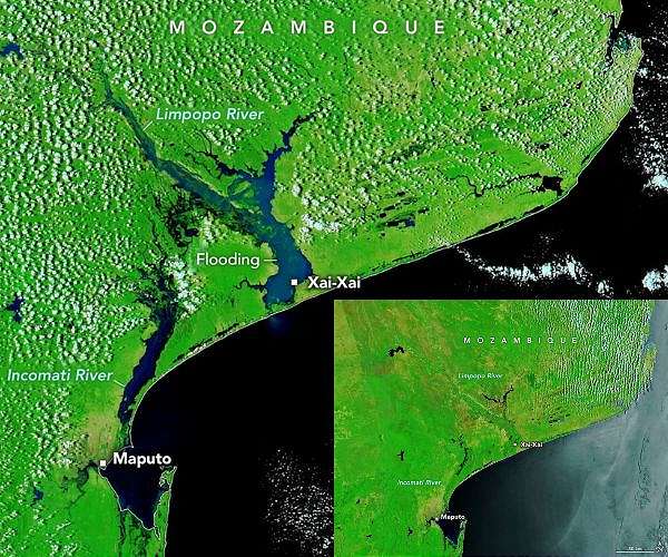
A pair of satellite images from NASA's Moderate Resolution Imaging Spectroradiometer (MODIS) instruments show the transformation of the landscape over the course of a little more than a month. In a Terra MODIS image acquired on December 17, 2025, only a thin line of river water threads through largely dry floodplains in southern Mozambique. By January 25, 2026, an Aqua MODIS false color image using bands 7-2-1 reveals extensive dark blue areas of standing water filling the floodplains along the Incomati and Limpopo rivers, contrasting with the green tones of the surrounding land.

The false color view highlights how water has poured out of the river channels and reservoirs and spread across agricultural land and settlements. A natural color version of the scene shows thick, sediment-laden plumes flowing through the river systems and discharging into the Mozambique Channel, signaling strong erosion and runoff from upstream catchments. Labels in the satellite imagery mark the locations of key urban centers such as Xai-Xai and Maputo, underscoring how close the floodwaters have come to major population centers.

Mozambique's National Disasters Management Institute reports that at least 600,000 people have been affected by the flooding so far, with hundreds of thousands displaced from their homes as waters rose and inundated low-lying areas. Authorities estimate that flooding has destroyed or damaged at least 30,000 homes, and they warn that totals are likely to increase as search and rescue operations proceed and more remote communities are reached.

Some of the hardest hit cities include the capital Maputo, the coastal city of Xai-Xai, and the inland city of Chokwe, where reports describe the Limpopo River flooding as overwhelming. Roads, bridges, and other critical infrastructure have been damaged or cut off, complicating efforts by emergency services and humanitarian organizations to reach stranded residents. Boats and helicopters have been used in some districts to rescue families trapped by rapidly rising water.

Agricultural areas have suffered extensive losses as floodwaters poured across cropland and grazing land. Mozambique's agriculture officials report that at least 180,000 hectares, or about 440,000 acres, of crops have been flooded, including fields that were approaching harvest. More than 150,000 head of livestock have also been lost, dealing a major blow to rural livelihoods in affected provinces and raising concerns about food security in the months ahead.

Health experts are warning of an elevated risk of cholera, diarrhea, and other waterborne diseases as contaminated water spreads and sanitation systems are disrupted in flooded communities. Stagnant pools and damaged water supplies create conditions that favor disease outbreaks, prompting calls for rapid deployment of safe water, sanitation, and hygiene support. Local authorities in at least one city have also reported crocodile attacks, as swollen rivers and floodwaters have carried the animals into urban neighborhoods and temporary camps where displaced people have gathered.

International and regional agencies are supporting Mozambique's response by providing forecasts, monitoring data, and emergency assistance. Hydrological and meteorological services, working with partners, are using satellite observations and modeling tools to track rainfall, river levels, and the evolution of the floods, helping officials prioritize evacuations and resource deployment. The event has also drawn attention to ongoing efforts to improve flood risk management in southern Africa through better early warning systems and coordinated response planning.

NASA's Earth Observing System Data and Information System (EOSDIS) and the Global Imagery Browse Services/Worldview platform are making near real time satellite imagery available to scientists, disaster managers, and the public. MODIS data from the Aqua and Terra satellites, along with other Earth observation missions, provide frequent, broad coverage that helps reveal where water has spread, how sediment plumes evolve, and which areas remain inundated over time. These observations contribute to both immediate emergency response and longer term assessments of how extreme rainfall and flooding events are affecting vulnerable regions such as southern Mozambique.

Related Links
NASA Earth Observatory
Earth Observation News - Suppiliers, Technology and Application

Subscribe Free To Our Daily Newsletters
Tweet

RELATED CONTENT
The following news reports may link to other Space Media Network websites.
EARTH OBSERVATION
NASA advances space based tracking of marine debris
Los Angeles CA (SPX) Jan 28, 2026
Detergent bottles and other litter can travel thousands of miles across the ocean before washing up on remote islands like Kaho'olawe in Hawaii, highlighting how persistent plastic pollution has become in the marine environment. A remote sensing technology developed at NASA's Jet Propulsion Laboratory that recently detected plastic pollution on land is now inspiring efforts to one day track ocean debris from space. In late 2025, scientists reported that NASA's Earth Surface Mineral Dust Source Inv ... read more

EARTH OBSERVATION
What happens when fire ignites in space? 'A ball of flame'

ISS astronauts splash down on Earth after first-ever medical evacuation

NASA Back for Seconds with New Food System Design Challenge

New orbital mapping system targets Earth Moon libration traffic

EARTH OBSERVATION
Elon Musk hints at buying Ryanair amid Starlink spat

Major equity deal backs Gilmour Space expansion of sovereign launch capability

Stratolaunch secures major funding to scale hypersonic flight services

Interstellar raises major Series F funding to expand launch and satellite business

EARTH OBSERVATION
Ancient deltas reveal vast Martian ocean across northern hemisphere

Tiny Mars' big impact on Earth's climate

The electrifying science behind Martian dust

Sandblasting winds sculpt Mars landscape

EARTH OBSERVATION
Tiangong science program delivers data surge

China tallies record launch year as lunar and asteroid plans advance

China harnesses nationwide system to drive spaceflight and satellite navigation advances

Shenzhou 21 crew complete eight hour spacewalk outside Tiangong station

EARTH OBSERVATION
Aerospacelab expands Pulsar navigation constellation work with new Xona satellite order

ThinkOrbital raises seed funding to advance orbital defense and construction systems

China outlines mega constellations in ITU satellite filings

Multiple satellite filings demonstrate transparency, responsibility and ambition: China Daily editorial

EARTH OBSERVATION
China starts large scale production of T1000 carbon fiber

Plastics everywhere, and the myth that made it possible

EU to show Google how to open up to rival AI services; Microsoft shares slide as AI spending surges

Smartphone kit offers low cost on site radiation dose checks

EARTH OBSERVATION
Icy cycles may have driven early protocell evolution

Cosmic dust chemistry forges peptide building blocks in deep space

Hidden magma oceans could shield rocky exoplanets from harmful radiation

Hidden magma oceans could shield rocky exoplanets from harmful radiation

EARTH OBSERVATION
Europa ice delamination may deliver nutrients to hidden ocean

Computer models let scientists peer into the mystery beneath Jupiter's clouds

Jupiter's moon Europa has a seafloor that may be quiet and lifeless

Uranus and Neptune may be rock rich worlds

Subscribe Free To Our Daily Newsletters


The content herein, unless otherwise known to be public domain, are Copyright 1995-2024 - Space Media Network. All websites are published in Australia and are solely subject to Australian law and governed by Fair Use principals for news reporting and research purposes. AFP, UPI and IANS news wire stories are copyright Agence France-Presse, United Press International and Indo-Asia News Service. ESA news reports are copyright European Space Agency. All NASA sourced material is public domain. Additional copyrights may apply in whole or part to other bona fide parties. All articles labeled "by Staff Writers" include reports supplied to Space Media Network by industry news wires, PR agencies, corporate press officers and the like. Such articles are individually curated and edited by Space Media Network staff on the basis of the report's information value to our industry and professional readership. Advertising does not imply endorsement, agreement or approval of any opinions, statements or information provided by Space Media Network on any Web page published or hosted by Space Media Network. General Data Protection Regulation (GDPR) Statement Our advertisers use various cookies and the like to deliver the best ad banner available at one time. All network advertising suppliers have GDPR policies (Legitimate Interest) that conform with EU regulations for data collection. By using our websites you consent to cookie based advertising. If you do not agree with this then you must stop using the websites from May 25, 2018. Privacy Statement. Additional information can be found here at About Us.