
The study, published in the journal Science, combines one of the most extensive geodetic datasets assembled for a continental collision zone with detailed modelling to track how the Tibetan Plateau is being stretched, squeezed and sheared. The authors describe it as one of the most comprehensive views yet of how a large continent deforms when subjected to immense tectonic forces. Their results challenge the long standing picture of strong, blocklike plates separated by sharp fault boundaries.
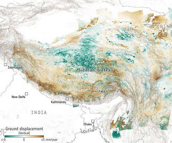
High resolution displacement maps derived from Copernicus Sentinel 1 radar data reveal that the eastern part of the Tibetan Plateau is moving eastwards by as much as 25 millimetres per year, while other zones move more slowly at up to 10 millimetres per year. The maps show broad swaths of the plateau migrating in different directions, with areas in green moving in the opposite sense to those in brown, highlighting both shortening and extension across the region. Vectors plotted alongside these coloured zones clarify the direction and rate of surface motion across the plateau.
The Tibetan Plateau, often called the roof of the world, formed through the long running collision between the Indian and Eurasian tectonic plates. Rising north of the Himalayas and south of the Kunlun mountains, it spans roughly 2.5 million square kilometres with an average elevation above 4500 metres. Its expanse covers the Tibet Autonomous Region and several Chinese provinces, and extends into parts of India, Pakistan, Nepal, Bhutan, Tajikistan and Kyrgyzstan.
Because it is the largest and highest continental collision zone on the planet, the plateau serves as a natural laboratory for geophysicists seeking to understand how continents change shape, position and internal structure under compression and extension. The new work refines that understanding by demonstrating how deformation is distributed over wide areas rather than being confined to a few stiff crustal blocks separated by major faults. The findings help to reconcile long standing discrepancies between observed surface motions and predictions from classical plate tectonics.
Horizontal deformation patterns show that strain is concentrated along several major fault systems, including the Altyn Tagh, Kunlun and Xianshuihe faults. On new strain rate maps, these zones appear as dark red bands marking where the crust is being stretched, shortened or sheared most rapidly over the measurement period. The detailed strain imagery makes it possible to identify where tectonic stress accumulates and how it is partitioned between different structures across the plateau.
According to the authors, earlier models treated the Tibetan Plateau as a patchwork of strong, rigid crustal blocks bounded by large strike slip faults that accommodate relative motion. The new results instead indicate that the crustal blocks themselves deform and that the major faults are significantly weaker than previously believed. This weaker, more ductile behaviour allows the plateau interior to respond more flexibly to the collision between India and Eurasia.
The research team is led by Tim Wright and brings together scientists from the UK Centre for Observation and Modelling of Earthquakes, Volcanoes and Tectonics, the universities of Leeds, Edinburgh, Exeter and Oxford, the China University of Geosciences in Beijing, Monash University in Australia, GNS Science in New Zealand, Columbia University in New York and South China Agricultural University in Guangzhou. This broad collaboration combines expertise in satellite geodesy, tectonics and numerical modelling to interpret the vast data archive.
This is the clearest picture yet of how a continent deforms under extraordinary forces, said lead author Tim Wright of the University of Leeds and COMET. By mapping land surface motion across the whole region in incredible detail, we can finally see how the Tibetan Plateau is actually moving, and the story it tells is very different from what the old models predicted. It is the highest resolution view to date of how the collision between India and Eurasia one of the most powerful tectonic events on the planet is reshaping Asia.
Co author Greg Houseman of China University of Geosciences Beijing and the University of Leeds said the results show that continents do not behave like a mosaic of stiff plates. The data show that continents do not behave like a mosaic of stiff plates. They flow, but their flow is enabled by major faults which act as weak zones. This helps explain why the extension in the southern and central Tibetan plateau is so widespread.
One of the most striking outcomes is a clear explanation for the widespread east west extension seen across the interior of the plateau. Modelling in the study indicates that the Kunlun Fault must be extremely weak, enabling the northern edge of central Tibet to slide relatively freely past the region to its north. This weak boundary allows the thickened plateau interior to collapse and stretch east west, releasing gravitational potential energy stored in the over thickened crust.
The weakness of the Kunlun Fault is the key that unlocks what is happening in central Tibet, said co author Jin Fang of the University of Leeds and COMET. It allows the interior of the plateau to essentially flow eastwards, helping to explain the regions widespread extension, something that has puzzled geologists for decades. The combination of satellite and ground measurements gives the clearest evidence yet for this behaviour.
Vertical motion across the plateau also emerges from the analysis. Maps of vertical ground displacement show green areas that have subsided by up to 5 millimetres per year and brown areas that have risen by a similar amount. These subtle motions reflect ongoing adjustments in crustal thickness and density as the plateau continues to evolve under tectonic and gravitational forces.
The investigation draws on more than 44000 Copernicus Sentinel 1 radar images acquired over a decade. Using synthetic aperture radar interferometry, the team generated over 340000 interferograms to detect minute changes in land surface position and infer ground displacement at millimetre scale. This dense coverage enables a continuous velocity field to be mapped over the entire plateau.
To complement the radar measurements, the researchers also analysed more than 14000 Global Navigation Satellite System observations from ground based receivers that track signals from GPS, Galileo and other satellite constellations. These data provide independent constraints on horizontal and vertical motions and help to validate the interferometric results. Together, the satellite radar and GNSS records yield an unprecedentedly detailed view of deformation across the plateau.
This wealth of satellite information allowed the team to build a high resolution velocity map of the Tibetan Plateau that resolves both broad scale trends and localised zones of intense deformation. The resulting products are already being fed into improved seismic hazard assessments, giving agencies and governments more accurate tools for evaluating earthquake risk. The authors note that the same approach can be extended to other tectonically active regions worldwide.
ESAs Sentinel 1 mission manager, Nuno Miranda, described the work as a remarkable achievement in geoscience, noting that the team has used a decade of Sentinel 1 observations to generate the highest resolution deformation maps of the Tibetan Plateau to date. The study highlights the central role of major fault systems in governing continental deformation and sets a new benchmark for models of seismic hazard. It also underscores the long term value of sustained radar observations for monitoring Earths dynamic surface.
Sentinel 1 is the first of the Copernicus Sentinel series developed by ESA to support the European Unions space programme. Equipped with a synthetic aperture radar instrument, it delivers all weather, day and night observations for a wide range of applications. Its data underpin Copernicus information services that help to manage the environment, monitor and respond to climate change and improve civil security.
Related Links
Sentinel-1 at ESA
Tectonic Science and News
| Subscribe Free To Our Daily Newsletters |
| Subscribe Free To Our Daily Newsletters |