
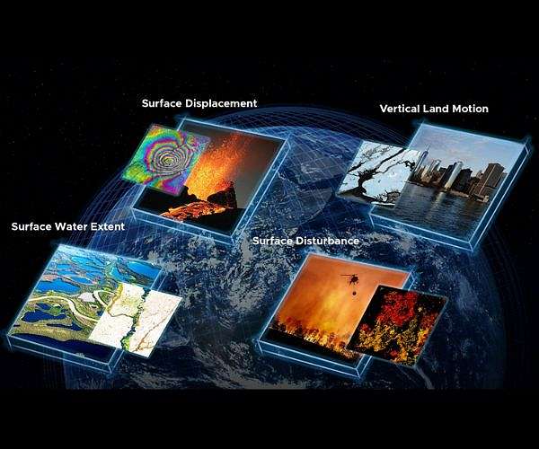
Instead of distributing raw satellite measurements that require specialized processing OPERA generates standardized analysis-ready products that agencies can plug directly into workflows for national security environmental monitoring disaster response and infrastructure risk assessment.
To meet these operational demands OPERA runs a cloud-based production system that scales to national coverage and regularly delivers several product suites through NASA Distributed Active Archive Centers including dynamic surface water extent surface disturbance and surface displacement data with a vertical land motion product planned to begin in 2028.
OPERA delivers high-quality ready-to-use satellite-derived information to enable federal agencies to better monitor environmental changes respond to natural disasters assess infrastructure risks and make data-driven decisions.
A recent OPERA stakeholder engagement workshop on Sept 11 2025 highlighted real-world use cases from partner agencies illustrating how these products inform decisions across sectors.
One application focuses on crop health in the South Fork watershed of central Iowa where persistent ponding on farmland contributes to yield losses altered soil conditions and changes in carbon storage that affect farmers insurers and researchers.
Scientists at the US Department of Agriculture Agricultural Research Services National Laboratory for Agriculture and the Environment are collaborating with OPERA to map these conditions using the Dynamic Surface Water Extent and Surface Disturbance product suites.
By stacking cloud-free high-resolution mosaics from DSWx with DIST and combining them with field measurements from USDA and university partners the OPERA NLAE team identifies depressions where water repeatedly pools across growing seasons.
These mapped depressions often align with zones of reduced crop yields elevated risk of crop mortality and accumulation of soil carbon and nutrients providing a basis for management decisions.
The resulting actionable maps show how often each location within fields experiences inundation and highlight waterlogged patches that farmers can target with drainage improvements soil-health interventions or land-use changes.
In one example a map of a field south of Iowa Falls in Hardin County Iowa uses color-coded pixels to portray the number of inundation events from May through October 2024 with higher counts marking deeper depressions and permanent water bodies including the Iowa River.
Beyond individual fields OPERA products support watershed-scale assessments of river migration oxbow lake formation and structural damage linked to intense derecho windstorms across the Midwest.
Together DSWx and DIST help pinpoint locations where improved tile drainage could enhance crop performance while reducing topsoil erosion and limiting downstream transport of nutrients that drive harmful algal blooms and low-oxygen zones as far away as the Mississippi Delta.
The collaboration between USDA ARS and OPERA shows how satellite observations can be transformed into practical tools that support farmers and conservation efforts while strengthening the resilience of US agriculture.
This work also demonstrates OPERAs role within the Satellite Needs Working Group framework as a provider of targeted observation-based solutions for federal users.
All OPERA data products are available at no cost to the public through NASA DAACs and can be discovered using the NASA Earthdata Search interface.
Related Links
NASA Jet Propulsion Laboratory OPERA Project
Earth Observation News - Suppiliers, Technology and Application
| Subscribe Free To Our Daily Newsletters |
| Subscribe Free To Our Daily Newsletters |