
DLR Chair of the Executive Board Anke Kaysser-Pyzalla highlighted the strategic importance of this capability for public authorities and industry. "TanDEM-X demonstrates the critical importance of continuous and comprehensive Earth observation for both the public sector and the economy. The mission also showcases Germany's expertise in the use of satellite-based radar technology as well as data processing and analysis. Space-based data is indispensable for informed decision-making - from disaster management and infrastructure planning to questions of sustainable development. With its first-class and consistent datasets, TanDEM-X helps to effectively support industry, public administrations and other public stakeholders such as local authorities. In light of the current geopolitical situation, it is vital to further expand these capabilities."
TanDEM-X is built around two satellites: TerraSAR-X, launched on 15 June 2007, and TanDEM-X, launched on 21 June 2010. After launch, TanDEM-X initially flew at a separation of about 20 kilometers behind TerraSAR-X while engineers calibrated the system. In October 2010, controllers maneuvered the pair into a close formation just a few hundred meters apart, which was the most demanding phase of the mission. The team then tested and adjusted the interferometric operation, in which one satellite transmits radar pulses to Earth while both satellites receive the reflected signals.
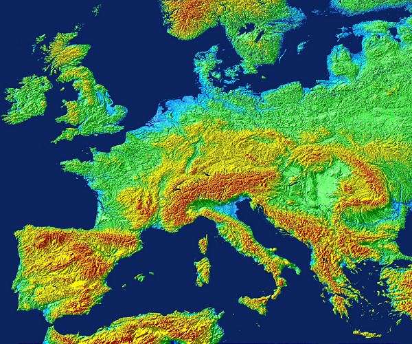
At the DLR site in Oberpfaffenhofen, specialists convert the interferometric measurements into three-dimensional elevation data and assemble them into a global product. The TanDEM-X digital elevation model has an absolute vertical accuracy on the order of one meter on a grid of 12 by 12 meters. The first global dataset was released in 2016 and is available as the Copernicus DEM through the European Space Agency. At an anniversary event on 11 December 2025 hosted by the DLR Microwaves and Radar Institute, DLR Divisional Board Member for Space Anke Pagels-Kerp emphasized the broad use of the data. "With TanDEM-X, we have achieved - together with partners from the private sector - a technological milestone in radar remote sensing. The mission's 3D radar data is being used across research, commercial applications and the security sector. This versatility underlines the major societal benefits of this mission."
Although TanDEM-X was originally designed for a mission life of about five years, fuel reserves and the condition of the hardware have allowed extended operations. Continued acquisitions have provided additional global coverages that track changes in topography over time. These multi-temporal datasets are used to derive "DEM Change Maps," which DLR makes available via its Geoservice. From early 2026, a separate digital elevation model based on data collected between 2017 and 2020 will be accessible through the TanDEM-X Science System. Airbus Defence and Space distributes commercial products from the mission, and ministries including the German Federal Ministry of Defence use the data. More than 6500 researchers worldwide have employed TanDEM-X products in scientific studies.
Scientific applications of TanDEM-X data span a wide range of geoscience and environmental topics. Researchers have quantified global glacier mass loss and tracked shifts in the grounding lines of outlet glaciers in Antarctica. Radar measurements have also been used to monitor growth and structure in major crops such as wheat, rice, and maize. The dataset has supported the production of a global forest versus non-forest classification, monitoring of managed forests, and a global map of surface water runoff. Analysts have also derived a global urban footprint that characterizes settlement patterns at high spatial resolution.
To maintain German radar Earth observation capabilities beyond TanDEM-X, DLR is developing concepts for a successor system. A key objective is to increase the accuracy of future global elevation models. Alberto Moreira, Director of the DLR Microwaves and Radar Institute, noted that the bar for any follow-on mission is high. "TanDEM-X has far exceeded all expectations, setting the bar correspondingly high for a successor mission. With the multistatic radar system MirrorSAR, which has proven to be particularly well suited, we aim to create a terrain model with an accuracy an order of magnitude higher than that of TanDEM-X. There is an equally great need for a new, more precise 3D image of Earth to keep pace with the rapidly improving quality of navigation and remote sensing data. While the resolution of remote sensing imagery is now at the metre scale, the most accurate global 3D dataset - the TanDEM-X digital elevation model - still has a grid resolution of twelve metres."
The MirrorSAR concept uses one main satellite that illuminates the target region and several companion satellites that function only as receivers. These receiver satellites forward the recorded signals to the main spacecraft. Because the receivers do not need a full radar transmitter system, their design can be simplified. This approach is compatible with small New Space platforms that are cheaper to build and launch, which could lower the cost of a future multistatic radar constellation.
Related Links
German Aerospace Center DLR
Earth Observation News - Suppiliers, Technology and Application
| Subscribe Free To Our Daily Newsletters |
| Subscribe Free To Our Daily Newsletters |