24/7 Space News
GPS NEWS
When 5G networks bolster satellite navigation
illustration only

When 5G networks bolster satellite navigation

by Riko Seibo
Tokyo, Japan (SPX) Dec 26, 2025

Finding accurate positions in dense urban areas remains difficult for satellite-based navigation systems, where high-rise buildings and signal blockages can cause large errors or complete loss of service. A recent study outlines a deeply integrated positioning method that combines commercial 5G New Radio (NR) signals with Global Navigation Satellite Systems (GNSS) to address these issues. By reinforcing 5G signal tracking and tightly merging it with satellite measurements, the approach improves both ranging stability and overall positioning accuracy in demanding city environments.

GNSS underpins many navigation applications, including smartphones and autonomous platforms, but its performance degrades sharply in so-called urban canyons, shaded streets, and other complex outdoor settings. Conventional attempts to compensate often introduce inertial sensors or vision-based systems, which can increase hardware cost, computational load, or sensitivity to lighting and environmental changes. In parallel, commercial 5G networks are expanding worldwide and provide dense base station deployment and wide bandwidth that are attractive for positioning, yet multipath interference, clock bias, and multi-beam transmissions have limited the practical use of 5G signals for robust navigation.

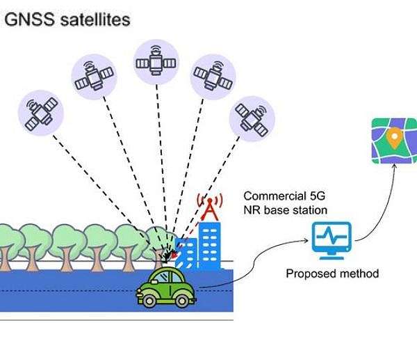
In a study published in Satellite Navigation in 2025, researchers from Wuhan University, The Chinese University of Hong Kong (Shenzhen), and Shandong University of Science and Technology propose a positioning framework that tightly integrates commercial 5G NR signals with GNSS. The framework is designed to enhance navigation reliability in urban settings where satellite signals are often degraded or sparse. By combining advanced 5G tracking techniques with real-time fusion of satellite and cellular measurements, the system delivers more accurate and stable position estimates under practical field conditions.

The team introduces a deep fusion strategy that links improvements in both signal tracking and position estimation. At the signal level, they develop a tracking method that jointly leverages 5G synchronization signals and reference signals to maintain stable lock in multipath-rich environments. This design reduces ranging errors compared with approaches that rely only on basic 5G tracking schemes.

To preserve performance when signals weaken, the researchers incorporate a phase-stabilized Kalman filter into the tracking loop, which helps sustain accurate carrier phase estimates even as signal quality fluctuates. Beyond the front-end tracking enhancements, the study applies an extended Kalman filter to deeply fuse the 5G and GNSS measurements. In contrast to loosely or tightly coupled schemes that leave tracking largely independent, the fused position and clock estimates feed back into the 5G tracking process in real time, correcting it as conditions change.

Field tests in complex outdoor environments demonstrate that this deep integration significantly improves positioning accuracy in both horizontal and vertical dimensions. The integrated system continues to provide reliable positions when satellite visibility is severely limited, conditions under which many GNSS-only solutions fail to maintain acceptable performance. These results indicate that combining 5G and satellite navigation can deliver robust localization under real urban conditions.

"This work shows that commercial 5G signals can do much more than support communication," an author of the study said. "By deeply integrating 5G with GNSS and addressing real-world challenges such as multipath and clock errors, we demonstrate a practical pathway toward reliable urban positioning. The key advantage is robustness - our system continues to work when satellite-only solutions struggle. This opens new possibilities for navigation in cities, where reliable positioning is often the hardest to achieve."

The findings suggest a broad range of potential uses in urban navigation and location-based services. Autonomous vehicles, delivery robots, smart transportation networks, and connected infrastructure could all draw on more dependable positioning in obstructed environments. Because the technique makes use of existing commercial 5G networks, it can be implemented without extensive changes to current infrastructure, supporting future connected systems that require continuous, accurate positioning.

Research Report:5G NR robust tracking and positioning with GNSS assistance

Related Links
Aerospace Information Research Institute Chinese Academy of Sciences
GPS Applications, Technology and Suppliers

Subscribe Free To Our Daily Newsletters
Tweet

RELATED CONTENT
The following news reports may link to other Space Media Network websites.
GPS NEWS
LEO internet satellites bolster navigation where GPS is weak
Columbus, OH (SPX) Dec 05, 2025
As intentional and unintentional interference with GPS grows worldwide, researchers have shown that radio signals from commercial low Earth orbit (LEO) internet constellations such as Starlink and OneWeb can provide an alternative source of navigation and positioning, especially in regions where GNSS performance is degraded. The new work indicates that passively received LEO signals can be turned into useful navigation beacons without modifying the satellites or accessing user data. Many sectors, ... read more

GPS NEWS
ESA reaches new benchmark in autonomous formation flying

Hydrogen peroxide thruster qualifies for ESA launcher attitude control

Billionaire Trump nominee confirmed to lead NASA amid Moon race

ISS to change commanders before Soyuz crew leaves orbit

GPS NEWS
Europe's Ariane 6 rocket puts EU navigation satellites in orbit

China launches carrier rocket to deploy experimental cargo ship and satellite

Hydrogen from ethanol reforming mapped as aviation fuel-cell pathway

Southern Launch to host INNOSPACE missions from South Australian spaceports

GPS NEWS
Perseverance rover cleared for long distance Mars exploration

HiRISE camera aboard Mars Reconnaissance Orbiter passes 100000 image milestone

Search for life should be top science priority for first human landing on Mars report says

GoMars model simulates Martian dust storms to improve mission safety

GPS NEWS
Shenzhou 21 crew complete eight hour spacewalk outside Tiangong station

Foreign satellites ride Kinetica 1 on new CAS Space mission

Experts at Hainan symposium call for stronger global space partnership

Triple Long March launches mark record day for Chinese space program

GPS NEWS
Financing the Next Space Boom: Options for Retail Investors to Stay Ahead

Southern Launch to Host Lux Aeterna Re-Entries South Australia

Smart modeling framework targets 6G spectrum chaos in space air and ground networks

K2 Space raises 250m to scale Mega class high power satellites

GPS NEWS
Top 5 High Volatility Games For 2026 Chase The Biggest Jackpots Today

How to pick the right web testing framework for your project

The Tech Behind 2025's Online Casino Boom - What's Powering the Surge?

What General Contractors Must Know About AI-Powered Estimating Software

GPS NEWS
Hubble pinpoints asteroid smash ups in nearby Fomalhaut system

Evolution study finds history and environment shifts can steer species in very different directions

Clues to the migration path of hot Jupiters in their orbits

Webb maps carbon rich atmosphere on distorted pulsar planet

GPS NEWS
Uranus and Neptune may be rock rich worlds

SwRI links Uranus radiation belt mystery to solar storm driven waves

Looking inside icy moons

Saturn moon mission planning shifts to flower constellation theory

Subscribe Free To Our Daily Newsletters


The content herein, unless otherwise known to be public domain, are Copyright 1995-2024 - Space Media Network. All websites are published in Australia and are solely subject to Australian law and governed by Fair Use principals for news reporting and research purposes. AFP, UPI and IANS news wire stories are copyright Agence France-Presse, United Press International and Indo-Asia News Service. ESA news reports are copyright European Space Agency. All NASA sourced material is public domain. Additional copyrights may apply in whole or part to other bona fide parties. All articles labeled "by Staff Writers" include reports supplied to Space Media Network by industry news wires, PR agencies, corporate press officers and the like. Such articles are individually curated and edited by Space Media Network staff on the basis of the report's information value to our industry and professional readership. Advertising does not imply endorsement, agreement or approval of any opinions, statements or information provided by Space Media Network on any Web page published or hosted by Space Media Network. General Data Protection Regulation (GDPR) Statement Our advertisers use various cookies and the like to deliver the best ad banner available at one time. All network advertising suppliers have GDPR policies (Legitimate Interest) that conform with EU regulations for data collection. By using our websites you consent to cookie based advertising. If you do not agree with this then you must stop using the websites from May 25, 2018. Privacy Statement. Additional information can be found here at About Us.