24/7 Space News
WATER WORLD
Neural network sharpens satellite ocean color in complex coastal waters
illustration only

Neural network sharpens satellite ocean color in complex coastal waters

by Riko Seibo
Tokyo, Japan (SPX) Jan 01, 2026
A recent study presents ACA-SIM, an atmospheric correction algorithm that uses satellite-in situ matchup data and neural networks to improve ocean color retrievals over coastal waters. The approach relies on real satellite radiance and in situ reflectance from Aerosol Robotic Network-Ocean Color (AERONET-OC) sites to reduce errors and striping artifacts in derived ocean color products, particularly in turbid and complex aerosol conditions such as the Bohai Sea, North Africa dust regions, and Australian bushfire areas.

Coastal waters contain suspended sediments, dissolved organic matter, and highly variable aerosols that make satellite observations difficult and can degrade estimates of water quality parameters. Conventional atmospheric correction schemes often assume simplified water and aerosol properties, which break down in turbid or dusty environments and are further compromised by sensor noise and striping. The study argues that a correction method trained directly on real-world conditions is needed to improve the reliability of global coastal ocean color monitoring.

Researchers from Xiamen University report ACA-SIM (atmospheric correction based on satellite-in situ matchup data) as an algorithm built on satellite-AERONET-OC matchups and implemented with a neural network trained on real satellite and field measurements. Their work, published on October 16, 2025 in the Journal of Remote Sensing, targets the long-standing problem of retrieving accurate remote-sensing reflectance (Rrs) from coastal waters affected by aerosols, dust, and smoke, and positions ACA-SIM as an alternative to current NASA methods.

ACA-SIM uses a multilayer neural network trained on more than 8,800 satellite-AERONET-OC matchups that span a wide range of water and aerosol types around the world. Unlike earlier schemes that relied heavily on simulated scenes, the model incorporates real sensor effects such as striping and stray light during training. In validation against independent field datasets, ACA-SIM achieved an average mean absolute percentage difference of about 15 percent in blue spectral bands, compared with about 32 percent for OC-SMART and more than 50 percent for NASA's standard algorithm.

The algorithm maintained stable performance under high solar angles, strong sun glint, and absorbing aerosol conditions, which commonly challenge traditional correction methods. When applied to MODIS-Aqua imagery over the Bohai and Yellow Seas, West Africa dust zones, and Australian bushfire regions, ACA-SIM removed negative Rrs values, reduced striping artifacts, and preserved realistic patterns of water masses in the resulting ocean color maps.

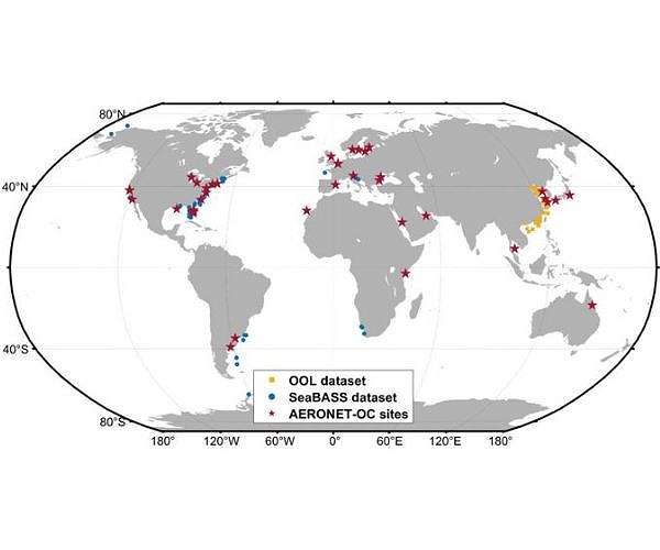
To build the training dataset, the team combined top-of-atmosphere reflectance (?t) from MODIS-Aqua with in situ Rrs measurements from more than 40 AERONET-OC stations worldwide. These matchups covered a broad range of viewing geometries, turbidity levels, and aerosol conditions, including marine and continental aerosols as well as strongly absorbing dust and smoke. A four-layer multilayer perceptron with 512, 256, 128, and 64 neurons was optimized to predict Rrs at 12 MODIS wavelengths between 412 and 869 nanometers.

Validation used both AERONET-OC and ship-based datasets and showed that ACA-SIM consistently outperformed NASA's standard and OC-SMART algorithms in accuracy and robustness. Statistical metrics including the coefficient of determination, mean absolute percentage difference, and bias were used to quantify performance gains over existing correction methods.

"Our goal was to let the algorithm learn from reality rather than simulation," said Prof. Zhongping Lee, corresponding author of the study. "By training ACA-SIM on genuine satellite-field matchups, we allowed it to capture subtle sensor behaviors and atmospheric effects that synthetic datasets cannot reproduce. The outcome is a smarter, more reliable correction system that ensures accurate monitoring of coastal ecosystems under even highly complex atmospheric scenarios."

The team assembled global AERONET-OC records from 2002 to 2024 and matched them with MODIS-Aqua radiance within a plus-or-minus one-hour window to maintain temporal consistency. A quality-control procedure removed contaminated pixels while retaining moderately glinted or hazy scenes so that the model would generalize better to operational conditions. Training used 80 percent of the matchup dataset, with the remaining 20 percent reserved for validation, and early-stopping criteria were applied to limit overfitting.

The success of ACA-SIM underscores the potential of data-driven correction strategies in Earth observation. The authors intend to expand the framework to other satellite sensors, including VIIRS and Sentinel-3, to build a unified cross-platform atmospheric correction system. By generating consistent and accurate ocean color products across instruments, such methods could improve tracking of algal blooms, sediment transport, and carbon fluxes and support management of coastal and marine environments under climate change.

Research Report:Atmospheric Correction of Coastal Waters Based on Satellite-AERONET-OC Matchups

Related Links
Xiamen University
Water News - Science, Technology and Politics

Subscribe Free To Our Daily Newsletters
Tweet

RELATED CONTENT
WATER WORLD
Viral resistant bacteria still help drive deep ocean carbon transport
Los Angeles CA (SPX) Dec 19, 2025
Marine bacteria help determine whether carbon remains near the ocean surface or sinks to deeper waters, but they live under constant threat from infection by viruses known as phages and frequently mutate to avoid those attacks. The new study examined what these resistance mutations cost individual cells and how those changes influence broader ecosystem function. Researchers investigated mechanisms of phage resistance in the marine bacterium Cellulophaga baltica and assessed how they affect the bac ... read more

WATER WORLD
Second ESCAPADE spacecraft completes key trajectory fix on path to Mars

China launches twin Shijian-29 satellites to test space-target detection tech

ESA reaches new benchmark in autonomous formation flying

Overseas scholars drawn to China's scientific clout, funding

WATER WORLD
North Korea tests hypersonic missiles, says nuclear forces ready for war

Starfighters completes supersonic tests for GE Aerospace ramjet program

Galileo satellites ride Ariane 6 to boost Europe navigation resilience

AI systems proposed to boost launch cadence reliability and traffic management

WATER WORLD
Sandblasting winds sculpt Mars landscape

Thin ice may have protected lake water on frozen Mars

Curiosity's Nevado Sajama postcard captures Mars on the eve of conjunction

Wind-Sculpted Landscapes: Investigating the Martian Megaripple 'Hazyview'

WATER WORLD
China harnesses nationwide system to drive spaceflight and satellite navigation advances

Shenzhou 21 crew complete eight hour spacewalk outside Tiangong station

Foreign satellites ride Kinetica 1 on new CAS Space mission

Experts at Hainan symposium call for stronger global space partnership

WATER WORLD
Time-expanded network model cuts complexity in mega constellation launch planning

Southern Launch to Host Lux Aeterna Re-Entries South Australia

Smart modeling framework targets 6G spectrum chaos in space air and ground networks

K2 Space raises 250m to scale Mega class high power satellites

WATER WORLD
Essential Strategies for Enhancing Data Integrity and Compliance in Today's Business Environment

Momentus to flight test 3D printed fuel tank on Vigoride 7

Satellites lined up for shared space computing power networks

Planet delivers first light image from Pelican 6 satellite capturing Lhasa Gonggar Airport

WATER WORLD
Deep Arctic gas hydrate mounds host ultra deep cold seep ecosystem

Joint ground- and space-based observations reveal Saturn-mass rogue planet

ALMA views giant dusty disk in Gomezs Hamburger with signs of early giant planet formation

We finally know how the most common types of planets are created

WATER WORLD
Jupiter's moon Europa has a seafloor that may be quiet and lifeless

Uranus and Neptune may be rock rich worlds

SwRI links Uranus radiation belt mystery to solar storm driven waves

Looking inside icy moons


The content herein, unless otherwise known to be public domain, are Copyright 1995-2026 - SpaceDaily.com. All websites are published in Australia and are solely subject to Australian law and governed by Fair Use principals for news reporting and research purposes. AFP, UPI and IANS news wire stories are copyright Agence France-Presse, United Press International and Indo-Asia News Service. ESA news reports are copyright European Space Agency. All NASA sourced material is public domain. Additional copyrights may apply in whole or part to other bona fide parties. All articles labeled "by Staff Writers" include reports supplied to Space Media Network by industry news wires, PR agencies, corporate press officers and the like. Such articles are individually curated and edited by Space Media Network staff on the basis of the report's information value to our industry and professional readership. Advertising does not imply endorsement, agreement or approval of any opinions, statements or information provided by Space Media Network on any Web page published or hosted by Space Media Network. General Data Protection Regulation (GDPR) Statement Our advertisers use various cookies and the like to deliver the best ad banner available at one time. All network advertising suppliers have GDPR policies (Legitimate Interest) that conform with EU regulations for data collection. By using our websites you consent to cookie based advertising. If you do not agree with this then you must stop using the websites from May 25, 2018. Privacy Statement. Additional information can be found here at About Us.
Subscribe Free To Our Daily Newsletters