
Roughly the size of a pickup truck, Sentinel-6B continues a more than 30-year series of U.S.-European satellite missions that monitor global sea level to within fractions of an inch. Once instrument and algorithm calibration is complete next year, the satellite will supply operational data products for ship routing, weather and ocean forecasting, national security users, and people living and working near the coast.
"NASA does incredible science using the unique vantage point of space every day to deliver life-saving data directly into the hands of decision-makers for storms, navigation, flooding, and more," said Nicky Fox, associate administrator, Science Mission Directorate, NASA Headquarters in Washington. "The ocean measurements that Sentinel-6B collected during its first months in orbit benefit all, providing key insights to ensure the prosperity and security of coastal communities around the globe."
In addition to mapping sea surface height, Sentinel-6B carries instruments to measure wind speed, wave height, atmospheric temperature, and humidity. U.S. agencies can use these observations to improve marine and weather services, and the data will also feed into Goddard Earth Observing System atmospheric forecast models that the NASA Engineering and Safety Center uses for planning safer re-entry trajectories for astronauts returning from Artemis missions.
Mission controllers report that the spacecraft and its payloads are operating as expected following commissioning. Key instruments in service include the Poseidon-4 Synthetic Aperture Radar altimeter, the Advanced Microwave Radiometer for Climate, the Global Navigation Satellite System - Radio Occultation sensor, and the Precise Orbit Determination Package, all of which are required to derive accurate global sea level measurements.
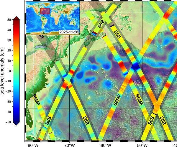
A visualization released with the first data set shows crisscrossing measurement tracks collected by Sentinel-6B on Nov. 26 as it orbited Earth, overlaid on combined sea-level data from other satellites. The image also incorporates data from its twin, Sentinel-6 Michael Freilich, which launched in 2020; in the composite, red areas indicate waters standing higher than the long-term average, while blue areas indicate lower-than-average sea level, and the still-uncalibrated readings are considered preliminary but scientifically useful.
Sentinel-6B and Sentinel-6 Michael Freilich together form the Copernicus Sentinel-6/Jason-CS (Continuity of Service) mission operated by an international partnership. The program was developed jointly by NASA, ESA (European Space Agency), EUMETSAT (European Organisation for the Exploitation of Meteorological Satellites), and the National Oceanic and Atmospheric Administration (NOAA) to maintain and extend the long-running satellite sea level record.
"These first light images from Sentinel-6B underscore the value of Earth science observations in providing life-saving and economic-empowering data to communities along our world's coastlines, where a third of the globe's population lives," said Karen St. Germain, director, NASA Earth Science Division at the agency's headquarters. "This achievement also highlights the power of partnerships with ESA, EUMETSAT, and our sister science agency NOAA in advancing our collective understanding of Earth systems and putting that Earth science understanding to work for the benefit of humanity."
Copernicus sea-level missions have produced a continuous global record since the early 1990s, documenting a doubling of the average rate of global sea level rise over that period. Current estimates show mean sea level increasing by about 0.17 inches, or 4.3 millimeters, per year, with regional variations that carry consequences for coastal infrastructure, shipping routes, and storm development.
Dave Gallagher, director of NASA's Jet Propulsion Laboratory in Southern California, noted the long-term investment that underpins the new mission. "The accuracy and precision of this mission's gold-standard dataset speaks to the foresight, more than 30 years ago, of investing in the technology and expertise that make it possible," he said. "We're proud to continue partnering to collect these critical measurements into another decade, and even prouder of the teams behind this most recent milestone."
Sentinel-6B currently flies at an altitude of about 830 miles, or 1,336 kilometers, trailing Sentinel-6 Michael Freilich by roughly 30 seconds along the same ground track. After the new satellite takes over as the primary reference mission for sea level, its twin will be moved to a different orbit while data continuity is maintained for users who rely on consistent measurements.
The Copernicus Sentinel-6/Jason-CS mission was jointly developed by ESA, EUMETSAT, NASA, and NOAA, with funding support from the European Commission and additional technical support from CNES. Managed for NASA by Caltech in Pasadena, JPL supplied three science instruments for each Sentinel-6 spacecraft: the Advanced Microwave Radiometer, the Global Navigation Satellite System - Radio Occultation instrument, and the laser retroreflector array, and NASA also provided launch services, ground systems for instrument operations, data processors for two of the instruments, and support to the international ocean surface topography science community.
Related Links
Sentinel-6B
Earth Observation News - Suppiliers, Technology and Application
| Subscribe Free To Our Daily Newsletters |

| Subscribe Free To Our Daily Newsletters |