24/7 Space News
EARTH OBSERVATION
China lofts Tianhui 7 geological survey satellite on Long March 4B
illustration only

China lofts Tianhui 7 geological survey satellite on Long March 4B

by Riko Seibo
Tokyo, Japan (SPX) Dec 31, 2025

China has orbited a new Tianhui-series satellite designed to strengthen the country's capabilities in geological mapping, land resource assessment and space-based scientific research. The multirole spacecraft, designated Tianhui 7, adds fresh capacity to a long-running line of Chinese survey satellites that supply high-value data for planners, scientists and national agencies.

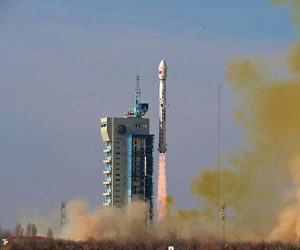
According to China Aerospace Science and Technology Corp, a Long March 4B rocket carrying Tianhui 7 lifted off at 12:12 pm local time on Tuesday from the Jiuquan Satellite Launch Center in the Inner Mongolia autonomous region. The three-stage launcher delivered the satellite into its planned sun-synchronous orbit, providing the stable, repeatable lighting conditions required for precision imaging and long-term environmental monitoring.

Tianhui 7 was built by the China Academy of Space Technology and is described as a multirole platform tasked with conducting geological surveys, land resources investigations and scientific experiments. In practice, this mission profile is expected to translate into detailed terrain mapping, tracking of land-use changes, and the observation of geological structures that can point to mineral resources or help assess natural hazards.

China's Tianhui, or "Sky Drawing," series has previously been used to provide high-resolution cartographic data and geospatial products that support infrastructure development, agriculture, disaster response and environmental management. While specific payload details for Tianhui 7 have not been disclosed, earlier satellites in the family have carried precision imaging instruments optimized for topographic mapping and multi-spectral observation, suggesting a similar or more advanced payload suite on board the new spacecraft.

The Long March 4B rocket used for the mission was developed by the Shanghai Academy of Spaceflight Technology and is a workhorse vehicle for launching Earth observation and survey payloads. In its standard configuration, the launcher can transport multiple satellites with a combined mass of up to 2.5 metric tons into a typical sun-synchronous orbit at an altitude of around 700 kilometers, making it well suited to missions like Tianhui 7 that require polar coverage and consistent revisit patterns.

Tuesday's flight marked the 92nd space mission carried out by China this year and the 622nd launch of the Long March rocket family, underscoring the high operational tempo of the country's space program. The successful insertion of Tianhui 7 continues a steady cadence of civil and dual-use Earth observation launches that are gradually densifying China's orbital survey infrastructure and expanding its independent access to critical geospatial data.

Operating from its near-polar orbit, Tianhui 7 is expected to regularly revisit target regions across China and beyond, building up time-series datasets that can be used to monitor geological evolution, track land degradation and desertification, and support more sustainable land and resource management. Combined with other elements of China's remote-sensing fleet, the new satellite's observations will feed into national databases that underpin planning for transportation corridors, urban growth and major development projects.

The satellite's role in scientific experiments also points to potential technology demonstrations or new remote-sensing techniques being tested on orbit. Such experiments may include improved image processing chains, onboard data compression or new ways of fusing satellite observations with ground and aerial measurements, all aimed at extracting more actionable information from the raw data streams reaching analysts on the ground.

With Tianhui 7 now on station and beginning its commissioning phase, Chinese engineers will spend the coming weeks checking spacecraft systems, calibrating instruments and validating data quality before the satellite is declared fully operational. Once routine service begins, its output is expected to be shared across multiple ministries, research institutes and emergency management agencies, further integrating space-derived information into day-to-day decision-making on the ground.

Related Links
China Academy of Space Technology (CAST)
Earth Observation News - Suppiliers, Technology and Application

Subscribe Free To Our Daily Newsletters
Tweet

RELATED CONTENT
The following news reports may link to other Space Media Network websites.
EARTH OBSERVATION
Under CERES watch Earth radiation budget record reaches 25 years
Los Angeles CA (SPX) Dec 30, 2025
NASA's Clouds and the Earth's Radiant Energy System, or CERES, has tracked Earth's energy budget from space for more than two decades using a suite of instruments flown on multiple satellites since 1997. The project, led from NASA's Langley Research Center, now draws on six operating sensors on Terra, Aqua, Suomi NPP, and NOAA-20, while two earlier units have ceased operations. The mission's record of instrument status, science findings, and team activities is documented through recurring Science Team M ... read more

EARTH OBSERVATION
ISS to change commanders before Soyuz crew leaves orbit

Lodestar Space wins SECP support to advance AI satellite awareness system

Micro nano robots aim to cut carbon buildup in closed life support systems

NASA extends ISS National Lab management contract through 2030

EARTH OBSERVATION
Hydrogen from ethanol reforming mapped as aviation fuel-cell pathway

Europe's Ariane 6 rocket puts EU navigation satellites in orbit

Southern Launch to host INNOSPACE missions from South Australian spaceports

Rocket Lab completes first dedicated JAXA mission with Electron launch

EARTH OBSERVATION
HiRISE camera aboard Mars Reconnaissance Orbiter passes 100000 image milestone

GoMars model simulates Martian dust storms to improve mission safety

Maven stays silent after routine pass behind Mars

Ancient Martian brines left bromine rich fingerprints in jarosite minerals

EARTH OBSERVATION
Foreign satellites ride Kinetica 1 on new CAS Space mission

Experts at Hainan symposium call for stronger global space partnership

Triple Long March launches mark record day for Chinese space program

China prepares Qingzhou cargo ship for low cost resupply flights

EARTH OBSERVATION
K2 Space raises 250m to scale Mega class high power satellites

Beyond Gravity positions new modular satellite platform for European LEO missions

Private capital targets mission-critical software power and platforms in new space economy

Applied Aerospace and PCX create US flight and space hardware group

EARTH OBSERVATION
Bible 1.0: How Ancient Canon Became Our First Large Language Models

One pull of a string is all it takes to deploy these complex structures

US denies visas to EU ex-commissioner, four others over tech rules

Modena team outlines staged roadmap to cut emissions from metal laser 3D printing

EARTH OBSERVATION
Deep Arctic gas hydrate mounds host ultra deep cold seep ecosystem

Can scientists detect life without knowing what it looks like

Clues to the migration path of hot Jupiters in their orbits

Ultra hot super Earth shows dense atmosphere over magma ocean

EARTH OBSERVATION
Uranus and Neptune may be rock rich worlds

SwRI links Uranus radiation belt mystery to solar storm driven waves

Looking inside icy moons

Saturn moon mission planning shifts to flower constellation theory

Subscribe Free To Our Daily Newsletters


The content herein, unless otherwise known to be public domain, are Copyright 1995-2024 - Space Media Network. All websites are published in Australia and are solely subject to Australian law and governed by Fair Use principals for news reporting and research purposes. AFP, UPI and IANS news wire stories are copyright Agence France-Presse, United Press International and Indo-Asia News Service. ESA news reports are copyright European Space Agency. All NASA sourced material is public domain. Additional copyrights may apply in whole or part to other bona fide parties. All articles labeled "by Staff Writers" include reports supplied to Space Media Network by industry news wires, PR agencies, corporate press officers and the like. Such articles are individually curated and edited by Space Media Network staff on the basis of the report's information value to our industry and professional readership. Advertising does not imply endorsement, agreement or approval of any opinions, statements or information provided by Space Media Network on any Web page published or hosted by Space Media Network. General Data Protection Regulation (GDPR) Statement Our advertisers use various cookies and the like to deliver the best ad banner available at one time. All network advertising suppliers have GDPR policies (Legitimate Interest) that conform with EU regulations for data collection. By using our websites you consent to cookie based advertising. If you do not agree with this then you must stop using the websites from May 25, 2018. Privacy Statement. Additional information can be found here at About Us.