24/7 Space News
EARTH OBSERVATION
AI challenge advances satellite-based disaster mapping
illustration only
AI challenge advances satellite-based disaster mapping
by ESA Staff Writers
Paris, France (SPX) Oct 31, 2025

Four teams from different countries have been recognised for their breakthrough work in using artificial intelligence to detect earthquake damage from space, marking the conclusion of a global competition organised by the European Space Agency in collaboration with the International Charter 'Space and Major Disasters' - commonly referred to as 'the Charter'.

The winning teams - TelePIX from the Republic of Korea, Datalayer from Belgium, DisasterM3 from Japan and Thales Services Numeriques from France - were honoured recently during a ceremony held at the Charter's 54th Board Meeting in Strasbourg, as France's French Space Agency, CNES, took leadership of the Charter for the next six months.

Combining the Charter's operational experience with ESA F-lab's drive for innovation, the 'AI for Earthquake Response Challenge', which is part of the ESA F-lab Challenges initiative, brought together 143 participants from 40 countries to explore how far artificial intelligence can go in automating post-disaster damage detection from space.

Competitors trained AI models capable of differentiating between damaged and undamaged buildings using one of the largest Earth observation datasets ever assembled for this purpose - more than 200 high-resolution images of five earthquake events.

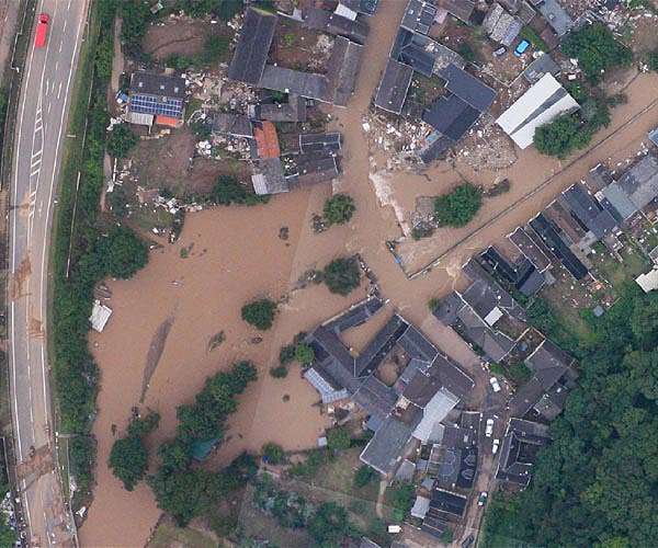
This image above shows the TelePIX team's winning model prediction over Mandalay, Myanmar, following the earthquake in March 2025. Mandalay was chosen as one of the final test sites in the challenge. Red shapes represent predicted damage. The blue dot indicates the location of the photo also featured below.

Philippe Bally, ESA representative of the Charter, said, "When an earthquake strikes, every minute counts. By accelerating the production of reliable building damage maps from satellite data, these models could one day help rescue teams reach affected communities faster".

A global collaboration for faster disaster response

Recognising that a single operator or satellite cannot meet the demands of disaster management, ESA and CNES initiated the International Charter Space and Major Disasters in 1999. They were joined by the Canadian Space Agency in 2000. It is now a collaboration between 17 space agencies that provides free satellite imagery to support disaster response worldwide.

Under a six-month rotation system, CNES has now taken over as lead agency, hosting the latest Charter Board meeting and the AI challenge awards ceremony together with ESA.

The AI for Earthquake Response Challenge was designed and implemented by ESA's F-lab together with an industrial team that created the environment, tools and evaluation framework for participants to develop and test their models.

The dataset used in the competition included over 200 high-resolution images from five major earthquakes and 13 sites - a total of 475 GB of data - sourced from the Charter's operational archives, a global cloud-based platform implemented by ESA and operated by an industrial consortium from Italy and Poland since 2018.

These came from a global virtual constellation of satellites, including Pleiades (CNES/Airbus), WorldView and GeoEye (USGS/Maxar), KOMPSAT-3 (KARI), Global (BlackSky) and Gaofen-2 (CNSA), making it one of the most diverse datasets ever built for AI-driven damage mapping.

Behind the scenes, the effort reflected the Charter's spirit of international cooperation. The Luxembourg Institute of Science and Technology and ACRI-ST (France) coordinated the competition, providing scientific oversight and ensuring the dataset's quality and relevance. Terradue (Italy), developer of the ESA Charter Mapper, enabled global access to the data through ESA F-lab's Earth Observation Training Data Lab, giving all teams an equal starting point.

Participants faced challenges similar to real-world emergency operations: multisensor imagery, variable resolutions, complex co-registration, and extreme class imbalance - such as in Mandalay, Myanmar, where only 0.2% of nearly half a million buildings were damaged.

Among the top performers, the European finalists stood out for their cutting-edge approaches. Datalayer leveraged scalable, cloud-based machine learning pipelines to process the massive dataset efficiently, while Thales Services Numeriques applied deep-learning and trustworthy-AI techniques from aerospace to pinpoint structural damage with precision.

Next steps

As operator of the Pleiades constellation and current lead agency of the Charter, CNES is now spearheading the post-challenge evaluation to assess how the best-performing AI models can be integrated into operational damage-mapping workflows.

By combining ESA F-lab's spirit of experimentation with the Charter's humanitarian mission, this initiative has shown how space data and AI can work hand in hand to improve rapid disaster response - a clear example of innovation and international collaboration.

Related Links
Observing the Earth at ESA
Earth Observation News - Suppiliers, Technology and Application

Subscribe Free To Our Daily Newsletters
Tweet

RELATED CONTENT
The following news reports may link to other Space Media Network websites.
EARTH OBSERVATION
Europe's new Sentinel-4 mission delivers first look at hourly air pollution maps
Paris, France (SPX) Oct 27, 2025
Europe has taken a major step toward real-time air quality monitoring with the release of the first images from the Copernicus Sentinel-4 mission. Operating aboard EUMETSAT's Meteosat Third Generation Sounder 1 (MTG-S1) satellite, Sentinel-4 has begun transmitting hourly observations of air pollutants across Europe - marking a milestone in the continent's environmental monitoring capabilities. Air pollution remains the leading environmental health threat in Europe, linked to hundreds of thousands ... read more

EARTH OBSERVATION
China vows massive high-tech sector development in next decade

Space exploration in the backyard, on a budget - how NASA simulates conditions in space without blasting off

China urges 'equal dialogue' with US as Apple's Cook visits

Space Ocean and Enduralock to unify orbital docking standards for in-space fluid and power transfer

EARTH OBSERVATION
Russia's new nuclear-powered missiles not a threat for now

Long March 5 rocket achieves breakthrough as tallest launch vehicle in Chinese space history

Final assembly of Vinci engines for Ariane 6 transitions to Germany

Rocket Lab sets November launch for next iQPS Earth-imaging satellite

EARTH OBSERVATION
Yeast demonstrates survival skills under Mars conditions

Are there living microbes on Mars? Check the ice

Blocks of dry ice carve gullies on Martian dunes through explosive sublimation

Yeast withstands Mars-like shocks and toxic salts in survival test

EARTH OBSERVATION
China aims to lead international space science with new discoveries

China expands space capabilities with new lunar and deep space milestones

China marks milestone 600th Long March rocket launch

Chinese astronauts complete fourth spacewalk of Shenzhou XX mission

EARTH OBSERVATION
Nordic countries launch joint forum to boost space sector collaboration

AST SpaceMobile reveals terms for one billion dollar convertible notes offering

Europe plans satellite powerhouse to rival Musk's Starlink

China deploys sixth batch of Spacesail communications satellites

EARTH OBSERVATION
Virtual reality helps people understand and care about distant communities

Copper price hits record high on US-China hopes

Stiff skeletons on demand in Pacific soft coral open path for bio-inspired materials

Earth-Based 3D Printing Technology Offers New Path to Affordable Housing in Australia

EARTH OBSERVATION
Newly found rocky super-Earth could become key focus in search for life

Hydrothermal vents may have triggered early molecular chemistry on ancient Earth

Ancient White Dwarf Reveals Ongoing Planetary Consumption

Newly found super-Earth orbits nearby star in promising habitable zone

EARTH OBSERVATION
Could these wacky warm Jupiters help astronomers solve the planet formation puzzle?

Out-of-this-world ice geysers on Saturn's Enceladus

3 Questions: How a new mission to Uranus could be just around the corner

A New Model of Water in Jupiter's Atmosphere

Subscribe Free To Our Daily Newsletters


The content herein, unless otherwise known to be public domain, are Copyright 1995-2024 - Space Media Network. All websites are published in Australia and are solely subject to Australian law and governed by Fair Use principals for news reporting and research purposes. AFP, UPI and IANS news wire stories are copyright Agence France-Presse, United Press International and Indo-Asia News Service. ESA news reports are copyright European Space Agency. All NASA sourced material is public domain. Additional copyrights may apply in whole or part to other bona fide parties. All articles labeled "by Staff Writers" include reports supplied to Space Media Network by industry news wires, PR agencies, corporate press officers and the like. Such articles are individually curated and edited by Space Media Network staff on the basis of the report's information value to our industry and professional readership. Advertising does not imply endorsement, agreement or approval of any opinions, statements or information provided by Space Media Network on any Web page published or hosted by Space Media Network. General Data Protection Regulation (GDPR) Statement Our advertisers use various cookies and the like to deliver the best ad banner available at one time. All network advertising suppliers have GDPR policies (Legitimate Interest) that conform with EU regulations for data collection. By using our websites you consent to cookie based advertising. If you do not agree with this then you must stop using the websites from May 25, 2018. Privacy Statement. Additional information can be found here at About Us.