| . |  |
. |
| . | |
. |
|
by Staff Writers Chennai, India (IANS) Sep 12, 2017
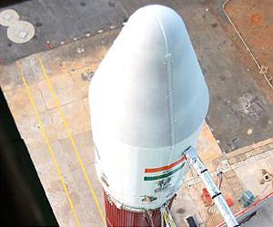
A total of 192 Indian objects are orbiting in space as of April 1, 2017, catalogued by US Space Surveillance Network, said a retired Indian scientist. He was citing the August 2017 issue of "Orbital Debris", a quarterly published by NASA. "Space objects include functional satellites as well as debris. The term catalogued means the space objects are tracked, updated, and their orbits are determined. The US and Russia maintain the catalogues as they have the technical capabilities," M.Y.S. Prasad, a former Director of the Satish Dhawan Space Centre (SDSC), told IANS. The Indian navigation satellite IRNSS-1H stuck inside the heat shield of PSLV-XL rocket that was launched on August 31 is the latest in orbit. Officials of the Indian Space Research Organisation (ISRO) said the navigation satellite-heat shield assembly - together weighing around 2.4-tonnes - now tumbling in outer space, is expected to re-enter the earth's atmosphere in a couple of months. According to Prasad, the present global capability of tracking the space debris is objects of bigger than 1-metre in GEO (geostationary equatorial orbit), and bigger than 10 cm in LEO (low earth orbit). Prasad said the limitation is due to the sizing and capability of ground tracking systems. The objects in GEO are tracked by optical telescopes while those in LEO are tracked by radars. In India, the multi-object tracking radar (MOTR) set up at the SDSC in Sriharikota is one of the biggest radars in the world for tracking space debris, Prasad added. He said MOTR is designed to track 50cm X50cm debris at a slant range of 1,000 km, and 30cm x 30cm debris at a slant range of 800 km and most of the debris, which cause damage to operational satellites can easily be tracked. Speaking about the re-entry of Indian navigation satellite IRNSS-1H that is stuck inside PSLV-XL rocket's heat shield Prasad said, the US space agency NASA should be requested to track and update the orbital elements of the Indian satellite. "Using that data as the base the future orbits of the navigation satellite should be predicted. When the satellites perigee (nearest point to earth) comes below 100 km then its reentry (into earth atomosphere) trajectory should be calculated and the impact region should be calculated two/three days before the actual impact," Prasad said. According to him there will be an element of uncertainty in predicting the impact region.
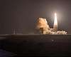 45th Space Wing supports successful Minotaur IV ORS-5 launch
Cape Canaveral AFS FL (SPX) Aug 26, 2017 The 45th Space Wing supported Orbital ATK's successful Minotaur IV rocket launch carrying the United States Air Force's Operationally Responsive Space 5 satellite Aug. 26, 2017, at 2:04 a.m. from Space Launch Complex 46 here. ORS-5 is a single satellite constellation with a primary mission to provide space situational awareness of the geosynchronous orbit belt for Combatant Commanders' urg ... read more Related Links ISRO Space Technology News - Applications and Research
|
|||||||||||||
| The content herein, unless otherwise known to be public domain, are Copyright 1995-2026 - SpaceDaily. All websites are published in Australia and are solely subject to Australian law and governed by Fair Use principals for news reporting and research purposes. By using our websites you consent to cookie based advertising. If you do not agree with this then you must stop using the websites from May 25, 2018. Privacy Statement. Additional information can be found here at About Us. |
 del.icio.us
 Digg
Digg Reddit
 Google