24/7 Space News
GPS NEWS
USGS introduces first fully integrated national geologic map
illustration only
USGS introduces first fully integrated national geologic map
by Clarence Oxford
Washington DC (SPX) Sep 01, 2025

In a major milestone for earth sciences, the U.S. Geological Survey (USGS) has released its most comprehensive national-scale geologic map to date, offering an unprecedented view of the geology both at and beneath the surface across the continental United States.

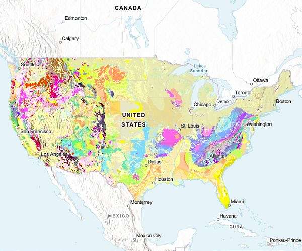
The new Cooperative National Geologic Map compiles data from more than 100 existing maps and provides the first nationwide platform where multiple layers of geologic information can be accessed in one place. Users can explore the age, composition, and distribution of rock and sediment units, from unconsolidated sand and gravel to ancient bedrock.

"Geologic maps have many uses, such as helping experts look for energy, mineral and water resources," explained Christopher Swezey, coordinator of the USGS National Cooperative Geologic Mapping Program. "They can also be used to assess earthquake risks and inform decisions about land use, infrastructure and community planning, and real estate and insurance."

The digital interface is designed for both specialists and the public. Users can search by geologic unit properties or click directly on the map for links to detailed local maps and expanded datasets. The tool supports hazard assessment, resource exploration, and education by providing analysis-ready geologic data.

"This map provides complete, analysis-ready geologic data for the nation, in a format that is easy to expand going forward," noted Joseph Colgan, USGS research geologist and team lead. "By providing this map online, we aim to enhance educational engagement and foster a greater public appreciation of geology."

The interactive platform will serve government agencies, private industry, and academic institutions. A cost-benefit study found that geologic maps return up to ten times their production cost through their applications in hazard mitigation, planning, and resource management.

A major advance in this project was the creation of a largely automated method to merge geologic maps from state surveys and USGS datasets. This reduced production time from decades to only three years. "Ongoing mapping efforts continually make new discoveries, but past national maps took decades to create while our new method allows us to update our national map faster than ever possible before," said Sam Johnstone, USGS research geologist and lead developer.

Long-standing collaboration with state geological surveys was central to the project, according to Dave Soller, senior program scientist for the USGS National Geologic Map Database. He emphasized that these partnerships strengthen national geoscience capabilities and improve the speed and efficiency of future map updates.

The Cooperative National Geologic Map is currently available for the lower 48 states, with Alaska, Hawaii, and U.S. territories planned for future inclusion. Users can access the map and related services through the National Geologic Map Database.

Research Report:The Cooperative National Geologic Map

Related Links
U.S. Geological Survey
GPS Applications, Technology and Suppliers

Subscribe Free To Our Daily Newsletters
Tweet

RELATED CONTENT
The following news reports may link to other Space Media Network websites.
GPS NEWS
Real time navigation breakthrough with new algorithm OiSAM FGO
Tokyo, Japan (SPX) Aug 22, 2025
In the race to improve autonomous systems, researchers in China have unveiled a new algorithm that accelerates navigation while maintaining precision. Called Optimized iSAM-Factor Graph Optimization (OiSAM-FGO), the method halves processing times compared with leading benchmarks yet delivers accuracy equal to state-of-the-art solutions. Traditional navigation tools face persistent trade-offs. Global Navigation Satellite Systems (GNSS) struggle in cities, while Inertial Navigation Systems (INS) dri ... read more

GPS NEWS
Dragon supply mission docks with International Space Station

Irish CubeSat proves wave based control for precise in orbit pointing

SpaceX scrubs Starship launch in latest setback

Intuitive Machines to Acquire KinetX Expanding Role in Deep Space Navigation and Mars Relay Services

GPS NEWS
Rocket Lab marks milestone with 70th Electron launch

SpaceX answers critics with successful Starship test flight

Space Machines finalizes Scintilla propulsion engine for Optimus Viper

SpaceX launches 28 Starlink satellites from Florida

GPS NEWS
Curiosity Captures Mars Landscape While Talking to an Orbiter

Preparing rock analysis methods on Earth for future Mars samples

Signs of recent life on Mars could be detected using new simple test

Martian fractures reveal ancient forces and icy flows

GPS NEWS
AI assistant supports Chinese space station astronauts

Spacesuit milestone reached with 20 spacewalks on Chinese station

Shenzhou 20 crew prepares for third spacewalk in coming days

Astronaut crew tests new generation spacewalk suits and conducts health research aboard Tiangong

GPS NEWS
Aerospacelab secures 94M EUR to expand satellite production and development

Dynamic satellite design advanced through Space RCO industry forum

Nullspace secures 2.5M seed funding to advance RF and quantum simulation software

SiriusXM activates SXM 10 to bolster North American audio network

GPS NEWS
Survey outlines advances and hurdles for orbital edge computing systems

CO2 increase to reshape geomagnetic storm impacts on satellites

Worlds tallest bridge clears load capacity trials

Musk's xAI sues Apple, OpenAI alleging antitrust violations

GPS NEWS
Model brings clarity to water rich exoplanets called steam worlds

Mapping star spots with NASA missions offers new insight into exoplanets

JWST observes planetary building blocks in Butterfly Nebula

TRAPPIST-1 d ruled out as Earth twin by Webb study

GPS NEWS
Jupiter birth dated through ancient molten rock droplets in meteorites

New Horizons begins record hibernation in Kuiper Belt

Fresh twist to mystery of Jupiter's core

Jupiter core mystery not explained by giant planetary impact

Subscribe Free To Our Daily Newsletters


The content herein, unless otherwise known to be public domain, are Copyright 1995-2024 - Space Media Network. All websites are published in Australia and are solely subject to Australian law and governed by Fair Use principals for news reporting and research purposes. AFP, UPI and IANS news wire stories are copyright Agence France-Presse, United Press International and Indo-Asia News Service. ESA news reports are copyright European Space Agency. All NASA sourced material is public domain. Additional copyrights may apply in whole or part to other bona fide parties. All articles labeled "by Staff Writers" include reports supplied to Space Media Network by industry news wires, PR agencies, corporate press officers and the like. Such articles are individually curated and edited by Space Media Network staff on the basis of the report's information value to our industry and professional readership. Advertising does not imply endorsement, agreement or approval of any opinions, statements or information provided by Space Media Network on any Web page published or hosted by Space Media Network. General Data Protection Regulation (GDPR) Statement Our advertisers use various cookies and the like to deliver the best ad banner available at one time. All network advertising suppliers have GDPR policies (Legitimate Interest) that conform with EU regulations for data collection. By using our websites you consent to cookie based advertising. If you do not agree with this then you must stop using the websites from May 25, 2018. Privacy Statement. Additional information can be found here at About Us.