| . |  |
. |
| . | |
. |
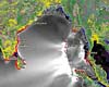
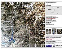
London, England (SPX) Nov 17, 2005 In London on Tuesday, the British National Space Centre (BNSC) formally became a Partner Agency of the International Charter 'Space and Major Disasters' on behalf of the Disaster Monitoring Constellation (DMC) Consortium. This means BNSC will participate in the Consortium's adherence to the Charter by performing certain functions during an initial period of two years. BNSC has already provided Project Manager support to previous Charter activations in liaison with ESA, including during the 2003 Soufriere Hills volcanic eruption in Montserrat in 2003 and following the Bhuj earthquake in India in 2001. The International Charter 'Space and Major Disasters' is a joint initiative to put space technology at the service of rescue authorities in the event of major disasters. Each member agency has demonstrated its commitment for using space technology to serve humankind when it is most in need of assistance when disasters of both natural and human origin strike the world's communities or wreak havoc on the environment. To date, the Charter has been activated more than 90 times. Recently, the Charter was activated after the October 8 earthquake in northern Pakistan and Kashmir which caused the deaths of more than 73 000 people. Charter members contributed with images from satellites, providing key cartographic information on remote, difficult-to-access areas affected. The images were used by national rescue teams, United Nations agencies and non-governmental organisations as base maps for assessing damage to infrastructures; for measuring the extent of landslides; and for selecting localities where emergency aid was most needed. The Disaster Monitoring Constellation (DMC) was designed as a proof of concept constellation, which is capable of multispectral imaging of any part of the world every day. It is unique in that each satellite is independently owned and controlled by a separate nation, but all satellites have been equally spaced around a sun-synchronous orbit to provide a daily imaging capability. The satellites are: Alsat-1 from Algeria, Nigeriasat-1 from Nigeria, Bilsat-1 from Turkey, UK-DMC from the UK and in the future Beijing-1 from China. Through the support of the British National Space Centre, DMC-builder Surrey Satellite Technology owns and operates the UK satellite in the constellation. The DMC was designed from the start to service many of the requirements of disaster monitoring. Its small satellites jointly provide daily revisits with a 600 km imaging swath width at 31-metre Ground Sample Distance (GSD) for broad area coverage. Disaster management authorities will now have access at any time to images from the whole of the DMC, adding to the major Earth Observation satellites that form the core of the Charter's space-based resources. "Having this constellation of satellites to join the Charter in support of so many requests makes us feel very pleased, in particular since the Charter has so recently proved the importance of space in helping to minimize suffering caused by natural and technological disasters all over the world," said Volker Liebig. Following the UNISPACE III conference held in Vienna, Austria, in July 1999, the European and French space agencies (ESA and CNES) initiated the International Charter 'Space and Major Disasters', with the Canadian Space Agency (CSA) signing the Charter on 20 October 2000. Other members include the Indian Space Research Organisation (ISRO), the US National Oceanic and Atmospheric Administration (NOAA) and the Argentine Space Agency (CONAE). Related Links British National Space Centre SpaceDaily Search SpaceDaily Subscribe To SpaceDaily Express
 Jakarta (AFP) Nov 17, 2005
Indonesia has activated the initial phase of a tsunami early warning system off the coast of Sumatra aimed at avoiding a repeat of the disaster caused by last December's quake-triggered tsunami on the island officials said Thursday. |
|
| The content herein, unless otherwise known to be public domain, are Copyright 1995-2006 - SpaceDaily.AFP and UPI Wire Stories are copyright Agence France-Presse and United Press International. ESA PortalReports are copyright European Space Agency. All NASA sourced material is public domain. Additionalcopyrights may apply in whole or part to other bona fide parties. Advertising does not imply endorsement,agreement or approval of any opinions, statements or information provided by SpaceDaily on any Web page published or hosted by SpaceDaily. Privacy Statement |

