| . |  |
. |
| . | |
. |
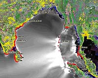
Jakarta (AFP) Nov 17, 2005 Indonesia has activated the initial phase of a tsunami early warning system off the coast of Sumatra aimed at avoiding a repeat of the disaster caused by last December's quake-triggered tsunami on the island officials said Thursday. Two sets of moored surface buoys and ocean-bottom pressure sensors were activated off western Sumatra on Tuesday by Indonesian and German scientists, said Edi Prihantoro of the Research and Technology Ministry. "The buoys will pick up and transmit data about sea tremors and pressure from the ocean sensor devices. This is part of the government's tsunami early warning system master plan," he told AFP. The instruments, the first two sets of a total of 15 to be installed along the coast of the vast archipelago, could also be uplinked to a satellite and information transmitted to a monitoring station near the town of Padang in West Sumatra province, said Prihantoro. The information is to be relayed to the population through mobile text messages, e-mail, fax and telephone. "Our next plan is to install the system in the Sunda Strait and off the southern coast of Java," he said. "The more instruments we have the better it will be but we and the German engineers agreed to have 15 for now," he said, adding that it was hoped they would be sufficient to cover all of Indonesia's coastal areas -- particularly the earthquake-prone zones. Indonesia sits on the so-called Pacific Rim of Fire, where the meeting of continental plates causes high volcanic and seismic activity. It lacked a warning system when a massive quake hit off Sumatra last December 26, unleashing a tsunami that swept up to seven kilometers (4.5 miles) inland and killed 217,000 people in 11 countries around the Indian Ocean rim. Of those, 131,000 were from Indonesia's Aceh province. The head of the tsunami seismotechnic department at the Geophysics Agency, Fauzi, told AFP earlier this week that along with the sensor buoys, 25 seismographs were being installed along Sumatra's west coast. By 2007, he said, the 15 buoys and more than 100 seismographs, which detect the speed of seismic waves to determine whether there is a risk of a tsunami, will have been installed. "Data from the seismograph will be analysed and relayed automatically through SMS or email in less than five minutes," Fauzi said. "Information from the buoys and tide gauges will come between five to 15 minutes after an earthquake," he said. The system is to be expanded and integrated into a warning system for endangered regions so that the population can be made aware of an impending disaster within minutes. Authorities were also developing coordinated escape routes and disaster preparedness in areas deemed to be at high risk from a tsunami, Fauzi said. Related Links SpaceDaily Search SpaceDaily Subscribe To SpaceDaily Express
 London, England (SPX) Nov 17, 2005
In London on Tuesday, the British National Space Centre (BNSC) formally became a Partner Agency of the International Charter 'Space and Major Disasters' on behalf of the Disaster Monitoring Constellation (DMC) Consortium. |
|
| The content herein, unless otherwise known to be public domain, are Copyright 1995-2006 - SpaceDaily.AFP and UPI Wire Stories are copyright Agence France-Presse and United Press International. ESA PortalReports are copyright European Space Agency. All NASA sourced material is public domain. Additionalcopyrights may apply in whole or part to other bona fide parties. Advertising does not imply endorsement,agreement or approval of any opinions, statements or information provided by SpaceDaily on any Web page published or hosted by SpaceDaily. Privacy Statement |