| . |  |
. |
| . | |
. |
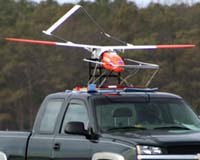
Greenbelt MD (SPX) Apr 29, 2004 NASA is providing new technology and satellite data to help forecasters at the National Oceanic and Atmospheric Administration (NOAA) create the best possible forecasts of severe springtime weather. New NASA data gathered from satellites, a lightning ground-tracking network and unmanned vehicles that fly into storms are some of the many tools used by NOAA, the federal agency charged with issuing weather forecasts. This data will help make the severe weather season safer for everyone. "It's an evolutionary process and partnership between NOAA and NASA," said Bill Patzert, oceanographer at NASA's Jet Propulsion Laboratory, Pasadena, Calif. "NOAA is the ultimate operational meteorological agency in the world, and NASA is developing state-of-the-art operational and fundamental research to make it better than ever. Together we're looking to the future to provide better and better service to the American public," he said. NOAA's National Weather Service (NWS) is responsible for monitoring and forecasting severe weather events. They issue watches and warnings for tornadoes, flash floods, non-precipitation events (such as high wind warnings), severe thunderstorms, and flooding, as well as daily weather forecasts. They reach the public with these warnings mainly through NOAA weather radio and the Internet. NASA uses data from its Earth-observing satellites and models to characterize and understand the way atmosphere, oceans and land interact. "Adding NASA satellite data and model output to NOAA forecasts could lead to more confident seven-day severe local storm forecasts, better prediction of thunderstorm occurrence by three hours, and an increase in tornado warning lead times by 18 minutes," said Dr. Marshall Shepherd, research meteorologist at NASA's Goddard Space Flight Center, Greenbelt, Md. NASA satellite data that enhances NOAA's weather model forecasts include surface wind data from QuikScat and rainfall data from the Tropical Rainfall Measuring Mission satellite. Launching in June 2004, NASA's Aura satellite will provide temperature and moisture information. That data will provide a clearer atmospheric picture, and it will improve forecast model prediction capabilities. Better understanding of jet steam locations, temperature, humidity fields and other atmospheric states are critical in assessing the potential for severe weather. Balloon observations taken twice daily at approximately 180 locations in the United States are the main source of this type of information. New NASA satellite observations can fill in the missing data spaces around the United States and surrounding oceans. The NASA-NOAA Joint Center for Satellite Data Assimilation was formed in 2002 to accelerate the use of satellite data within global-scale weather forecast models operated by NOAA. NASA's Short-term Prediction Research and Transition (SPoRT) Center at NASA's Marshall Space Flight Center, Ala., is working closely with NWS forecasters in the southern United States to improve severe weather forecasting. NASA scientists are using data obtained from the ground-based Lightning Mapping Array in northern Alabama to better understand the relationship between lightning flash rates and tornado-producing thunderstorms. The SpoRT Center provides lightning data to surrounding NWS forecast offices in real time for use in severe weather warning decision-making. "There has been one event where the NASA lightning data prompted NWS forecasters in the Huntsville, Alabama office to issue a tornado warning on a strong convective cell earlier than they would have otherwise," said Dr. William Lapenta, SpoRT Center research meteorologist. A weak tornado occurred after the warning was issued. Research is also underway to improve flooding forecasts by incorporating new satellite data from the NASA Atmospheric InfraRed Sounder instrument into NWS weather forecast models on a regional scale. In February, NASA's Langley Research Center, Hampton, Va., flight-tested the Global Positioning System Reflectometer on an unmanned aerial vehicle to collect data in severe weather situations. In 2002, NASA, universities and industries conducted the Altus Cumulus Electrification Study in Florida, the first time a remotely piloted aircraft was used to conduct lightning research. Related Links High Energy Transient Explorer SpaceDaily Search SpaceDaily Subscribe To SpaceDaily Express
 Huntsville (SPX) Apr 29, 2004
Scientists at the National Space Science and Technology Center in Huntsville, Ala., are using information gleaned from NASA satellites, aircraft and field research to better understand dynamics behind tornadoes, lightning, hurricanes and other destructive forces of nature. The research center is a partnership with the Marshall Center, industry and Alabama universities. |
|
| The content herein, unless otherwise known to be public domain, are Copyright 1995-2006 - SpaceDaily.AFP and UPI Wire Stories are copyright Agence France-Presse and United Press International. ESA PortalReports are copyright European Space Agency. All NASA sourced material is public domain. Additionalcopyrights may apply in whole or part to other bona fide parties. Advertising does not imply endorsement,agreement or approval of any opinions, statements or information provided by SpaceDaily on any Web page published or hosted by SpaceDaily. Privacy Statement |