| . |  |
. |
| . | |
. |
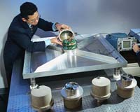
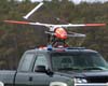
Huntsville (SPX) Apr 29, 2004 Scientists at the National Space Science and Technology Center in Huntsville, Ala., are using information gleaned from NASA satellites, aircraft and field research to better understand dynamics behind tornadoes, lightning, hurricanes and other destructive forces of nature. The research center is a partnership with the Marshall Center, industry and Alabama universities. Scientists at the National Space Science and Technology Center (NSSTC) in Huntsville, Ala., are using information gleaned from NASA satellites, aircraft and field research to better understand dynamics behind tornadoes, lightning, hurricanes and other destructive forces of nature. "A better understanding of severe weather can help people year-round," said Dr. Tim Miller of the Global Hydrology and Climate Center (GHCC) in Huntsville. "The Center is conducting a variety of unique research projects that could someday help forecasters better predict and prepare the public for severe weather." The GHCC is one of seven research centers at the National Space Science and Technology Center. Center scientists have played leadership roles in better understanding tornadoes, lightning, hurricanes and other natural phenomenon. Sometimes, researchers have found, one dangerous element of severe weather is a key to understanding another. Using a combination of ground- and space-based weather monitoring equipment, NSSTC scientists have documented dozens of cases in which lightning rates increased dramatically as severe storms developed. This offers an early clue for weather forecasters to take a more detailed look at other storm characteristics with radar -- and perhaps a chance for them to get warnings out earlier, saving more lives. Other research answers the question of where lightning is more likely to occur. A map created in 2001 by National Space Science and Technology Center scientists offered the first animated glimpse of annual lightning activity worldwide. Compiled using satellite data, each frame of the animation represents the average lightning activity worldwide on a single day of the year. The map shows that lightning avoids the ocean, but frequently strikes in Florida. It's likely to strike in the Himalayas and even more so in central Africa. The animated maps also clearly show how lightning-producing storms are caused by the Sun's daily heating of Earth's surface and atmosphere. This was the first time scientists mapped the global distribution of lightning, noting variations by latitude, longitude, day of year and time of day. In another first, to better understand both the causes of an electrical storm's fury and its effects on our home planet, NSSTC scientists in 2002 used a tool no atmospheric scientist had ever used before to study lightning � a remotely piloted aircraft, commonly called an uninhabited aerial vehicle or "UAV." This marked the first time an uninhabited aerial vehicle was used to conduct lightning research. This project, called the Altus Cumulus Electrification Study, united researchers from NASA, universities and industry. By chasing down thunderstorms in Florida using the remotely piloted aircraft, the scientists achieved dual goals � gathering weather data safely and testing new aircraft technology. Such studies have the potential to help forecasters improve weather prediction, especially for storms that may produce severe weather. And, by learning more about these individual storms, scientists hope to better understand weather on a global scale. Sometimes, the greatest barrier to more detailed forecasts is the amount and quality of data available to forecasters. Researchers at the center are collaborating with other agencies to change that. A new generation of weather satellites, to be launched around 2011 by National Oceanic and Atmospheric Administration, will carry advanced sensors capable of producing higher-resolution images than today's satellites. A sharper, richer picture of the ever-changing atmosphere � available to forecasters in near real-time � will bring a new level of detail and accuracy to short-term forecasts. But in the meantime, sensors of this caliber are already in orbit aboard NASA's newest climate research satellites, Terra and Aqua. Supported by scientists at the National Space Science and Technology Center, collaboration between the National Weather Service and NASA is laying the foundation for using new satellite technology right now. Known as Short-term Prediction Research and Transition, or SpoRT, the program uses data from a sensor called MODIS � or MODerate-resolution Imaging Spectrometer � aboard NASA satellites. MODIS gleans between 16 and 100 times more detail than current weather satellites, giving researchers a head start in incorporating highly detailed data into weather forecasts. The NSSTC is also home to hurricane researchers who helped lead a series of field research investigations called Convection And Moisture Experiments, or CAMEX. Sponsored by the Earth Science Enterprise at NASA Headquarters in Washington, the most-recent CAMEX mission in 2001 united researchers from 10 universities, five NASA centers and the National Oceanic and Atmospheric Administration. Armed with airplanes, satellite observations, ground-based radar and a fleet of other sophisticated instruments, the researchers met the potentially deadly and destructive storms head-on, gathering data vital to improve hurricane modeling and prediction. Monitoring storms simultaneously from near sea level to 65,000 feet, the researchers monitored temperature, pressure, humidity, precipitation, wind speed, lightning and ice crystal sizes. NSSTC researchers are currently using this information to identify hurricane precipitation and cloud electrical field patterns and to study how they relate to hurricane intensity. They are also studying how the characteristics of a landfalling hurricane are changed once the storm begins to interact with the coastline. Together, lessons learned from these studies have the potential to lead to more accurate interpretations of satellite information and methods for using this information for hurricane intensity forecasting. The National Space and Technology Center is a partnership among NASA's Marshall Space Flight Center in Huntsville, Alabama research universities, industry and other federal agencies. Related Links More at Marshall SpaceDaily Search SpaceDaily Subscribe To SpaceDaily Express
 Greenbelt MD (SPX) Apr 29, 2004
NASA is providing new technology and satellite data to help forecasters at the National Oceanic and Atmospheric Administration (NOAA) create the best possible forecasts of severe springtime weather. |
|
| The content herein, unless otherwise known to be public domain, are Copyright 1995-2006 - SpaceDaily.AFP and UPI Wire Stories are copyright Agence France-Presse and United Press International. ESA PortalReports are copyright European Space Agency. All NASA sourced material is public domain. Additionalcopyrights may apply in whole or part to other bona fide parties. Advertising does not imply endorsement,agreement or approval of any opinions, statements or information provided by SpaceDaily on any Web page published or hosted by SpaceDaily. Privacy Statement |