| . |  |
. |
| . | |
. |
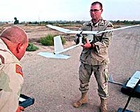
El Segundo CA (SPX) Oct 12, 2005 Northrop Grumman Corporation has successfully led the first demonstration of a system that autonomously controls low-flying unmanned aerial vehicles (UAVs) to deliver real-time surveillance data to U.S. military forces in urban battle zones. The flight exercise showed that individual warfighters could receive video surveillance information about enemy positions on handheld computers, making their efforts safer and more effective. Northrop Grumman's Integrated Systems sector is leading the U.S. Department of Defense's "HURT" program under an $11.6 million contract awarded in January 2005. The effort is funded and managed by the Defense Advanced Research Projects Agency (DARPA) with the Air Force Research Lab serving as technical and contracting agent. HURT stands for heterogeneous urban RSTA (reconnaissance, surveillance and target acquisition) team. The demonstration was conducted Sept. 22, 2005, at the former site of George Air Force Base in Victorville, Calif., where a grid of abandoned streets and buildings is used to train military forces for urban warfare. The exercise began with four small UAVs -- two Ravens and a Pointer (both fixed-wing aircraft) and a RMAX helicopter -- deployed at low altitudes under HURT system control. Participants on the ground with handheld computers played the role of military forces in the field. The warfighters viewed surveillance images of the entire area but could also request specific information about a suspected enemy position by moving a cursor over the subject on the handheld monitor. The HURT system autonomously prioritized each request and directed the most suitable UAV to the location for a closer look while maintaining continuous broad-area surveillance by the other UAVs. Currently, military forces in urban warfare situations have no direct access to surveillance data, nor can they control the high-altitude aircraft and satellites that collect it. In addition, high-altitude platforms are more limited in providing information with the detail and timeliness required in a rapidly changing urban combat zone. Because the HURT system doesn't require modifications to the UAV systems it controls, different types of unmanned aircraft can easily be assembled to meet various mission requirements. The Sept. 22 demonstration utilized small UAV systems, but the technology could eventually be used with larger systems such as Northrop Grumman's RQ-4 Global Hawk, X-47B Joint Unmanned Combat System, Fire Scout vertical takeoff and landing UAV, and RQ-5A Hunter. HURT technology could be easily adapted for other military applications and missions. In addition to Northrop Grumman, key members of the HURT development team include Honeywell Laboratories, SRI International, Teknowledge Corporation, AeroVironment and Planet 9 Studios, as well as researchers from NASA, the Georgia Institute of Technology and the University of Pennsylvania. Related Links SpaceDaily Search SpaceDaily Subscribe To SpaceDaily Express
 St Petersburg FL (SPX) Oct 12, 2005
Cyber Defense Systems, and its wholly owned subsidiary Techsphere Systems International, announced Tuesday the signing of a Space Act Agreement between Techsphere Systems International and NASA's Langley Research Center |
|
| The content herein, unless otherwise known to be public domain, are Copyright 1995-2006 - SpaceDaily.AFP and UPI Wire Stories are copyright Agence France-Presse and United Press International. ESA PortalReports are copyright European Space Agency. All NASA sourced material is public domain. Additionalcopyrights may apply in whole or part to other bona fide parties. Advertising does not imply endorsement,agreement or approval of any opinions, statements or information provided by SpaceDaily on any Web page published or hosted by SpaceDaily. Privacy Statement |