| . |  |
. |
| . | |
. |
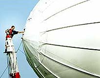
St Petersburg FL (SPX) Oct 12, 2005 Cyber Defense Systems, and its wholly owned subsidiary Techsphere Systems International, announced Tuesday the signing of a Space Act Agreement between Techsphere Systems International and NASA's Langley Research Center This agreement partners NASA, TechSphere Systems, Unitech, Applied EM, and RTI International to conduct a study for the purpose of developing a microwave sensor conceptual modeling tool to enhance the existing Langley Research Center vehicle analysis tools to enable the sensor/vehicle to be jointly developed from the science requirements. This Innovative Partnership Project will provide an assessment of ongoing airship technology development and support the validation of existing Langley Research Center modeling. Lightweight conformal "paint-on" antenna concepts will also be studied to predict its overall performance. "This is a wonderful opportunity for us to contribute to an exciting and innovative partnership supported by NASA," said Mike Lawson, President of Techsphere Systems International. "This Space Act Agreement, sponsored by NASA's Innovative Partnership Program, will help achieve NASA's goals of utilizing High Altitude platforms for gathering of hard science for the betterment of our Earth," stated Wes Lawrence, Deputy Chief of the Electromagnetics and Sensors Branch of NASA Langley Research Center. After the commencement of this agreement, periodic reports will be completed summarizing Techsphere Systems (TSI) airship flight operations and computer modeled test results for Cyber's M.A.R.S. airship design. The flights conducted and planned in the near future will provide aerodynamics information from the results of Aerosphere airship flight tests. This information will be used with Langley Research Center System Analysis models and the assessment of the Airship technology as a stepping process to achieve an overall high altitude capability in the 60,000 to 70,000 foot altitude regime. This will allow predicted station keeping capability for NASA remote sensing applications. "We are very pleased to be partnered with NASA and thrilled to offer our products and expertise to further develop an already outstanding model established by NASA's Langley Research Center," commented Mr. Billy Robinson, CEO of Cyber Defense Systems. Related Links SpaceDaily Search SpaceDaily Subscribe To SpaceDaily Express
 El Segundo CA (SPX) Oct 12, 2005
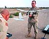
Northrop Grumman Corporation has successfully led the first demonstration of a system that autonomously controls low-flying unmanned aerial vehicles (UAVs) to deliver real-time surveillance data to U.S. military forces in urban battle zones. |
|
| The content herein, unless otherwise known to be public domain, are Copyright 1995-2006 - SpaceDaily.AFP and UPI Wire Stories are copyright Agence France-Presse and United Press International. ESA PortalReports are copyright European Space Agency. All NASA sourced material is public domain. Additionalcopyrights may apply in whole or part to other bona fide parties. Advertising does not imply endorsement,agreement or approval of any opinions, statements or information provided by SpaceDaily on any Web page published or hosted by SpaceDaily. Privacy Statement |