| . |  |
. |
| . | |
. |
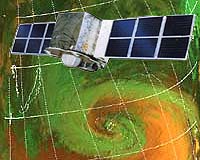
Beijing (XNA) Jul 18, 2005 Commission of Science Technology and Industry for National Defense held a handover ceremony on July 14 for China's first geostationary operational meteorological satellite successfully developed and launched by China Aerospace Science and Technology Corporation. After trial operation for six months, the satellite is officially delivered to China Meteorological Administration (CMA) for full operation. Speaking at the ceremony, Sun Laiyan, deputy director of Commission of Science Technology and Industry for National Defense and director general of the China National Space Administration (CNSA), said that the successful delivery marks a great leap forward of Chinese aerospace industry on its way to service-oriented practice from application and experiment based practice. Zhang Qingwei, managing director of China Aerospace Science and Technology Corporation, noted that FY - 2C is the third geostationary meteorological satellite China has ever launched. It employs the self-spin stabilization method and has a designed service life of three years. The remote sensing instruments onboard the satellite could perform the 36,000-km high-altitude observation over the earth, which is of high time resolution and has an advantage in dynamically monitoring the disastrous weather caused by meso- and micro-scale weather system. Meanwhile, FY - 2C is also good at obtaining and transmitting data, enabling continuous meteorological monitoring over the earth. Qin Dahe, director of CMA, note that China has so far established polar orbit and stationary operation series of meteorological satellites, among which the FY meteorological satellites have all been included into the World Meteorological Organisation Satellite Observation Network, with China's meteorological satellites to be the key members. Starting from June 27, the flood season observation pattern of FY - 2C has been started, which can catch 48 relevant images every day. Source: Xinhua News Agency Related Links SpaceDaily Search SpaceDaily Subscribe To SpaceDaily Express
 Paris (ESA) Jul 18, 2005
As part of ESA's validation and long-term monitoring programme for the atmospheric chemistry instruments on board Envisat, scientists are now facing the challenges of launching huge balloons in Equatorial Brazil to fill a gap in the validation dataset. |
|
| The content herein, unless otherwise known to be public domain, are Copyright 1995-2006 - SpaceDaily.AFP and UPI Wire Stories are copyright Agence France-Presse and United Press International. ESA PortalReports are copyright European Space Agency. All NASA sourced material is public domain. Additionalcopyrights may apply in whole or part to other bona fide parties. Advertising does not imply endorsement,agreement or approval of any opinions, statements or information provided by SpaceDaily on any Web page published or hosted by SpaceDaily. Privacy Statement |