| . |  |
. |
| . | |
. |
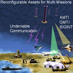
Herndon - June 1, 2000 - AeroAstro has won a $1.2 million contract with the US Air Force Research Laboratory to develop a system for high-precision ranging and position determination between multiple satellites orbiting in precisely-controlled formations. The new "Star Ranger" system combines differential GPS technology and an inter-satellite communications link between clustered co-orbiting satellites. The technology exchanges data between spacecraft to determine relative position and range to centimeter accuracy or better. Distributed aperture missions, such as JPL New Millennium's ST-3, the Air Force's Techsat21, and future missions such as NASA's Terrestrial Planet Finder require the very fine positioning which this system will enable. Dr. Rick Fleeter, President and CEO of AeroAstro, said, "The Star Ranger technology facilitates the next generation of microsatellite missions and applications including formation flying and proximity operations around other spacecraft. AeroAstro is committed to leading the way in delivering this new breed of micro-spacecraft solutions." The new technology uses an inter-satellite data link in the Ku-band, building on miniaturized communications technology being developed for NASA. By integrating differential GPS into the system, very precise information can be obtained on range and position between two or more co-orbiting spacecraft. Other technologies AeroAstro is developing for the next generation of micro-satellites include miniaturized communications components as part of the New Millennium ST-5 Nanosatellite Constellation Trailblazer mission team, modular spacecraft bus architectures and components such as Bitsy-SX under development for NASA for flight in 2001, high-capability propulsion and on-orbit maneuvering systems, and integration and test processes for low-cost multiple-spacecraft missions.
 Greenbelt - June 1, 2000 -
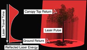
 NASA's investment in airborne LIDAR (light detection and ranging) mapping technology is paying major dividends in an assessment of earthquake hazards in the Puget Lowland of Washington state. |
|
|
|
|
|
|
|
|
|
|
|
|
|
| The content herein, unless otherwise known to be public domain, are Copyright 1995-2006 - SpaceDaily.AFP and UPI Wire Stories are copyright Agence France-Presse and United Press International. ESA PortalReports are copyright European Space Agency. All NASA sourced material is public domain. Additionalcopyrights may apply in whole or part to other bona fide parties. Advertising does not imply endorsement,agreement or approval of any opinions, statements or information provided by SpaceDaily on any Web page published or hosted by SpaceDaily. Privacy Statement |