| . |  |
. |
| . | |
. |
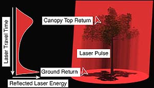
Greenbelt - June 1, 2000 - NASA's investment in airborne LIDAR (light detection and ranging) mapping technology is paying major dividends in an assessment of earthquake hazards in the Puget Lowland of Washington state. Dr. David Harding, a geophysicist at NASA's Goddard Space Flight Center in Greenbelt, Md., is working with local municipalities and the United States Geological Survey (USGS) to map earthquake hazards along the Seattle fault zone using commercial airborne LIDAR mapping capabilities. A commercial LIDAR mapping industry has emerged in the past few years, based in part on instrumentation and techniques first developed by NASA. The results of a pilot LIDAR mapping effort and the status of current LIDAR activities in the Puget Lowland were presented by Harding on Wednesday, May 24 as part of the American Society of Photogrammetry and Remote Sensing annual conference. "LIDAR is the best technique we have right now to map the topography of the ground where it is covered by vegetation," says Harding, "The images reveal much more detail at the surface than previous methods. Until a LIDAR mapping survey was flown no surface trace of faults in the Seattle fault zone had been identified, neither on the ground nor from remote sensing, due to the dense vegetation cover of the Pacific Northwest temperate rainforests. Before LIDAR technology, aerial photographs were used to map surface features, but thick forest cover made locating the ground virtually impossible. Using LIDAR technology, scientists can filter out high measurements from leaves or branches above the surface to get a more accurate elevation map of the underlying ground. Harding represents NASA in the Puget Lowland LIDAR Consortium that has contracted with Terrapoint, LLC of Houston to map a large region of the Puget Lowland, including the entire extent of the Seattle fault zone. Terrapoint was funded by NASA to commercialize the airborne laser mapping system developed by Bill Krabill, a researcher at NASA's Wallops Flight Facility, for the Arctic Ice Mapping program. Funding for the Puget Lowland mapping is being provided by a congressional appropriation to Kitsap County through the USGS, NASA's Solid Earth and Natural Hazards program, the City of Seattle and the Puget Sound Regional Council. The Consortium's efforts were inspired by LIDAR data of Bainbridge Island in Puget Sound collected in 1996 by the commercial company Airborne Laser Mapping for the Kitsap Public Utility District (KPUD). The LIDAR image collected under the direction of Greg Berghoff at the KPUD, revealed a previously unrecognized fault scarp or an offset in the land surface formed by faulting, in the Seattle fault zone. In order to guide collection of additional Puget Lowland LIDAR data by the consortium, Harding and Berghoff evaluated the Bainbridge Island data to understand how it revealed the fault scarp. Once a fault scarp is found, USGS scientists dig a trench across the scarp to examine the folded and faulted rock layers. A detailed study of these layers and dating of material from within the fault zone can reveal the number, size and age of the earthquake events that formed the scarp. "Natural hazard assessment is only one application of this mapping technique," says Harding. "Assessing stream quality for salmon spawning, documenting forest cover conditions, evaluating land use and urban sprawl, and floodplain mapping will also benefit greatly using LIDAR mapping technology." Harding says that the data from the Puget Lowland also will be used to test observations from NASA's recently completed Shuttle Radar Topography Mission and from an upcoming LIDAR mission, the Ice, Cloud, and Land Elevation Satellite (ICESat). Related Links
 Laurel - June 1, 2000 -
 NEAR Shoemaker continues its detailed exploration of Eros from 50 km orbit, a process which resembles in some ways an archaeological expedition. |
|
|
|
|
|
|
|
|
|
|
|
|
|
| The content herein, unless otherwise known to be public domain, are Copyright 1995-2006 - SpaceDaily.AFP and UPI Wire Stories are copyright Agence France-Presse and United Press International. ESA PortalReports are copyright European Space Agency. All NASA sourced material is public domain. Additionalcopyrights may apply in whole or part to other bona fide parties. Advertising does not imply endorsement,agreement or approval of any opinions, statements or information provided by SpaceDaily on any Web page published or hosted by SpaceDaily. Privacy Statement |