| . |  |
. |
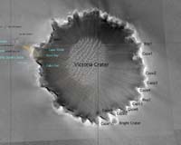
Pasadena CA (SPX) Oct 02, 2006 On Mars, over the next few weeks, two robotic explorers will reach 1000 sols a piece. At a real cost that's now under $350,000 a day, the 2004 Mars Rovers have been an engineering and scientific triumph beyond all expectation. And crowning the success of the missions has been the arrival of Opportunity at the rim of "Victoria Crater", and the awakening of Spirit from it's long sebatical during the Martian winter. Now at Victoria, after traveling 9,279.34 meters (5.77 miles) in 952 sols the Mars Rover team has rewarded by some of the most spectacular views seen on this mission. The week began with a checkout of basic mobility functions using the new flight software: arc, turn, go-to-waypoint and visual odometry. Also checked were a few of the mobility test criteria such as the time-of-day limits, suspension limits and a new capability for keep-out zones (areas deemed too dangerous to rove). Later in the week, Opportunity drove 60.1 meters (197 feet) over three sols to our current location at the top of "Duck Bay." Sol-by-sol summaries: Sol 947 (Sept. 22, 2006): Opportunity's panoramic camera took 13-filter, quarter-frame images of the targets "Macaroni" and "Rockhopper," and a mosaic of images of "Kitty Clyde's Sister." During the afternoon communication-relay pass by NASA's Mars Odyssey orbiter, the miniature thermal emission spectrometer was used to evaluate Macaroni and Rockhopper. The navigation camera checked for clouds and the panoramic camera assessed the clarity of the atmosphere with a tau measurement. Sol 948: The morning of this sol, the rover monitored dust buildup and targeted the sky and ground with its miniature thermal emission spectrometer. Opportunity executed a series of mobility tests to check out the new version of its flight software. Post-drive imaging included 360-degree view by the navigation camera and an image mosaic by the panoramic camera. Sol 949: In the morning of this sol, the panoramic camera imaged the sky and measured for atmospheric clarity. The navigation camera looked for clouds and the miniature thermal emission spectrometer did a sky and ground measurement. This sol contained un-targeted remote sensing because it was the third of a three-sol plan. The panoramic camera continued to be busy, taking another tau measurement and sky images. Before the Odyssey pass, the navigation camera took images of the sky (called "sky flats") for calibration purposes. During the Odyssey pass, Opportunity used its miniature thermal emission spectrometer. Sol 950: Opportunity used part of the morning block of this sol to take a panoramic camera tau measurement and to look for clouds with its navigation camera. It also shot images of the sky with the panoramic camera and observed the sky and ground with its miniature thermal emission spectrometer. The rover completed another panoramic camera tau measurement before it drove 30.2 meters (99 feet) toward Victoria Crater's rim. Post-drive imaging included hazard avoidance camera imaging, a panoramic camera mosaic and a navigation camera 360-degree image. Sol 951: This morning, Opportunity used its panoramic camera to survey the sky. The rover then took a panoramic camera tau measurement, drove 26.4 meters (87 feet) toward Duck Bay and completed post-drive imaging, including navigation and panoramic camera mosaics. The navigation camera looked for clouds and the panoramic camera imaged the sky. Sol 952: Opportunity used its miniature thermal emission spectrometer to measure the sky and ground. The rover took pre-drive panoramic camera and navigation camera images. Opportunity drove 3.5 meters (11.5 feet) toward the rim's edge, then took a navigation camera mosaic. There was a post-drive navigation camera cloud observation before the rover shut down for the afternoon. Before the Odyssey pass, the panoramic camera made a tau measurement and the miniature thermal emission spectrometer measured the sky and ground during the orbiter's pass. The panoramic camera took a sunset tau measurement. Sol 953 (Sept. 29, 2006): In the morning of this sol, the panoramic camera imaged the sky, the navigation camera looked for clouds and the miniature thermal emission spectrometer measured the sky and ground. This sol is the first of two sols of targeted remote sensing in Duck Bay before Opportunity will drive off to "Cape Verde." The rover is at its closest approach to Victoria Crater and it has an incredible view! The plan for the remainder of this sol is to: take a panoramic camera tau measurement, look for clouds with the navigation camera, take a navigation camera mosaic in the drive direction, and take part one of a large panoramic camera panorama. The miniature thermal emission spectrometer will take a vertical scan of "Cabo Frio" during the Odyssey pass. The plan also calls for another navigation camera scan for clouds and a panoramic camera 13-filter examination of Cabo Frio to support the miniature thermal emission spectrometer in the morning of sol 954. As of sol 952 (Sept. 27, 2006), Opportunity's total odometry is 9,279.34 meters (5.77 miles). Related Links Mars Rovers at JPL Mars Rovers at Cornell Mars News and Information at MarsDaily.com
 Laurel MD (SPX) Oct 02, 2006
The most powerful mineral-mapper ever sent to Mars has opened its protective cover and is about to begin its search for hints of past water on the red planet. The Compact Reconnaissance Imaging Spectrometer for Mars (CRISM), designed and built by the Johns Hopkins University Applied Physics Laboratory in Laurel, Md., is one of six science instruments aboard NASA's Mars Reconnaissance Orbiter. |
|
| The content herein, unless otherwise known to be public domain, are Copyright 1995-2006 - SpaceDaily.AFP and UPI Wire Stories are copyright Agence France-Presse and United Press International. ESA PortalReports are copyright European Space Agency. All NASA sourced material is public domain. Additionalcopyrights may apply in whole or part to other bona fide parties. Advertising does not imply endorsement,agreement or approval of any opinions, statements or information provided by SpaceDaily on any Web page published or hosted by SpaceDaily. Privacy Statement |

