| . |  |
. |
Laurel MD (SPX) Oct 02, 2006 The most powerful mineral-mapper ever sent to Mars has opened its protective cover and is about to begin its search for hints of past water on the red planet. The Compact Reconnaissance Imaging Spectrometer for Mars (CRISM), designed and built by the Johns Hopkins University Applied Physics Laboratory in Laurel, Md., is one of six science instruments aboard NASA's Mars Reconnaissance Orbiter. CRISM's spring-loaded cover had been closed since the orbiter's launch in August 2005, protecting the imager's sensitive telescope optics from fuel residue and heat as the spacecraft eased into orbit around Mars. Today, a day after turning on CRISM's power and putting the device through a series of performance tests, operators opened the cover and verified that it had deployed properly. "Everything went smoothly and our team is looking forward to our first images later this week," says Dr. Scott Murchie, CRISM principal investigator from the Applied Physics Laboratory (APL). CRISM will look for areas that were wet long enough to leave a mineral signature on the surface, searching for the spectral traces of aqueous and hydrothermal deposits, and mapping the geology, composition, and stratigraphy of surface features. The imager will map areas on the martian surface as small as 60 feet (about 18 meters) across, with the orbiter at its average altitude of about 190 miles (300 kilometers). Offering greater capability to map spectral variations than any similar instrument sent to another planet, CRISM will read 544 "colors" in reflected sunlight to detect minerals in the surface. Its highest resolution is about 20 times sharper than any previous look at Mars in near-infrared wavelengths. By identifying sites most likely to have contained water, CRISM data will help determine the best potential landing sites for future Mars missions seeking fossils or even traces of life. "It's been a long 13 months since launch, waiting throughout the aerobraking phase until we could safely expose the instrument optics," says Peter Bedini, the CRISM project manager from APL. "The time was well used, though, as we completed the development of a very sophisticated system for collecting, processing, and distributing the data we'll soon be taking with CRISM."
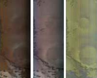
New Spectrometer Begins Its Global Map of Mars The image is part of the second multispectral survey strip, taken at 22:36 UTC (6:36 p.m. EDT) on Sept. 27, 2006. Only minimal processing of the data has been done at this early point in the Mars Reconnaissance Orbiter's mission. The strip crosses part of the north polar region named Olympia Undae, and stretches between 76.7 north latitude, 141.9 east longitude and 85.5 north, 115.8 east. From the top, the northern end of the image crosses layers of dusty and clean ice in the north polar cap. Moving south the image covers dusty sedimentary deposits, dark sand dunes, and outlying polar ice deposits. (The thumbnail shown here covers only the northernmost part of the full image. Click on the thumbnail to view the full product.) This image shows three representations of the 72 colors. The left panel is a nearly true-color composite in which the blue, green, and red planes are 0.44, 0.53, and 0.60 micrometer light - nearly as the human eye would see. The contrast between the bright ice and dark dunes is so large that the dunes are barely seen. The middle panel is false color constructed from infrared wavelengths just beyond the range of the human eye. The blue, green, and red planes cover 0.80, 0.95, and 1.06 micrometer light. In this rendering of the data the differences between ice- and soil-rich regions are not as apparent because the colors of ice and dust are similar in this wavelength region. The right panel uses 1.15, 1.8, and 2.25 micrometer light in the blue, green and red planes and provides a dramatically different view of the scene. The areas of highest ice content appear in blue, and those with a mix of dust and ice - most of the scene - appear yellowish. The dunes are now visible against the ice because of their higher brightness at longer infrared wavelengths, and appear ruddy brown. The Compact Reconnaissance Imaging Spectrometer for Mars is one of six science instruments on NASA's Mars Reconnaissance Orbiter. Led by The Johns Hopkins University Applied Physics Laboratory, Laurel, Md., the CRISM team includes expertise from universities, government agencies and small businesses in the United States and abroad. NASA's Jet Propulsion Laboratory, a division of the California Institute of Technology in Pasadena, Calif., manages the Mars Reconnaissance Orbiter mission for NASA's Science Mission Directorate, Washington. CRISM's mission: Find the spectral fingerprints of aqueous and hydrothermal deposits and map the geology, composition and stratigraphy of surface features. The instrument will also watch the seasonal variations in Martian dust and ice aerosols, and water content in surface materials - leading to new understanding of the climate. Related Links Mars Reconnaissance Orbiter HiRoc at Arizona CRISM at APL Mars News and Information at MarsDaily.com
 Pasadena CA (SPX) Oct 02, 2006
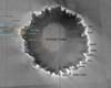
On Mars, over the next few weeks, two robotic explorers will reach 1000 sols a piece. At a real cost that's now under $350,000 a day, the 2004 Mars Rovers have been an engineering and scientific triumph beyond all expectation. And crowning the success of the missions has been the arrival of Opportunity at the rim of "Victoria Crater", and the awakening of Spirit from it's long sebatical during the Martian winter. |
|
| The content herein, unless otherwise known to be public domain, are Copyright 1995-2006 - SpaceDaily.AFP and UPI Wire Stories are copyright Agence France-Presse and United Press International. ESA PortalReports are copyright European Space Agency. All NASA sourced material is public domain. Additionalcopyrights may apply in whole or part to other bona fide parties. Advertising does not imply endorsement,agreement or approval of any opinions, statements or information provided by SpaceDaily on any Web page published or hosted by SpaceDaily. Privacy Statement |

