| . |  |
. |
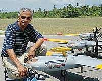
Arlington VA (SPX) Apr 18, 2006 U.S. researchers have successfully sent a fleet of aerial drones over the Indian Ocean to track pollutants responsible for dimming Earth�s atmosphere. The researchers, part of a consortium led by the Scripps Institution of Oceanography at the University of California, San Diego, sent the instrument-bearing autonomous unmanned aerial vehicles on 18 data-gathering missions in the vicinity of the Maldives, an island chain nation southwest of India. The Maldives AUAV Campaign, or MAC, as it is called, sent groups of three aircraft in a vertical formation that allowed their onboard instruments to observe conditions below, inside and above clouds simultaneously. The researchers said they hope the flights will produce data in unprecedented detail about how pollution particles cause dimming and contribute to the formation of clouds - which amplify the dimming caused by the pollution. "MAC has demonstrated that lightweight AUAVs and their miniaturized instruments are an effective and inexpensive means of simultaneously sampling clouds in polluted environments from within and from all sides," said Jay Fein, program director of the National Science Foundation�s Division of Atmospheric Sciences, which funded MAC. Previous research projects have attempted stacked flights with manned aircraft, but the difficulty and cost of assembling and coordinating three similar aircraft have prevented the sort of repeated measurements required to sample clouds adequately. "Based on MAC's success it is possible that in five years, hundreds of lightweight AUAVs will be documenting how human beings are polluting the planet and hopefully provide an early warning system for potential environmental disasters in the future," said Scripps scientist V. Ramanathan. The skies over the Indian Ocean visibly bear the imprint of human activities in South Asia, frequently in what are termed atmospheric brown clouds, particulate-laden haze and cumulus clouds that frequently blanket the region. The role that dust and aerosols from industrial, urban and agricultural emissions play in creating this brown haze is an important variable to researchers who study climate change, in particular how human activities could be changing the planet's albedo, or reflectivity. Cloud cover cools Earth's surface by reflecting solar radiation back into space. In recent years, researchers have realized pollution in the atmosphere, and the dimming and cooling it causes, could be skewing estimates of the true magnitude of global-warming trends observed in recent decades. Ramanathan�s consortium developed the drones and integrated them with miniaturized instruments that can obtain aerosol-cloud-solar radiation data in remote regions once considered unobtainable: multi-dimensional portraits of clouds created in polluted environments over periods of several hours. The "Manta" AUAVs, constructed by Advanced Ceramics Research, of Tucson, Ariz., bear an instrument package that weighs less than five kilograms (11 pounds). The packages include sensors for measuring solar radiation, cloud-drop size and concentrations, particle size and concentrations, turbulence, humidities and temperatures. The scientists flew the AUAVs last March 6 through March 31, taking off from an airport on the island of Hanimaadhoo in the Maldives. Each AUAV tracked a separate component of brown cloud formation. The lowest, flying beneath the cloud, quantified the input of pollution particles and measured quantities of light that penetrated the clouds. The aircraft flying through the cloud measured the cloud's response to the introduction of particles. The aircraft flying above the cloud measured the amount of sunlight reflected by the clouds into space and the export of particles out of the clouds. "We're excited about being involved in the study of atmospheric brown clouds using cutting edge flight control software developed in our unmanned aerial vehicles," said Anthony Mulligan, Advanced Ceramics Research�s chief executive officer. "We're have provided scientists with a way to further their research, and look forward to providing a low-cost, effective way to gather additional information." Other funding partners in the research included the National Oceanic and Atmospheric Administration, NASA, the G. Unger Vetlesen Foundation and the Alderson Foundation. The research was also supported by the United Nations Environmental Program and the Republic of Maldives. Related Links SCRIPPS NSF
 Arlington VA (SPX) Apr 18, 2006
U.S. researchers have successfully sent a fleet of aerial drones over the Indian Ocean to track pollutants responsible for dimming Earth's atmosphere. |
|
| The content herein, unless otherwise known to be public domain, are Copyright 1995-2006 - SpaceDaily.AFP and UPI Wire Stories are copyright Agence France-Presse and United Press International. ESA PortalReports are copyright European Space Agency. All NASA sourced material is public domain. Additionalcopyrights may apply in whole or part to other bona fide parties. Advertising does not imply endorsement,agreement or approval of any opinions, statements or information provided by SpaceDaily on any Web page published or hosted by SpaceDaily. Privacy Statement |