| . |  |
. |
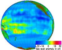
Greenbelt - Jun 03, 2002 NASA researchers have created a tool that can predict El Nino events months before they occur, by linking variations in rainfall patterns over the Indian Ocean with developing El Ninos. Scott Curtis of the University of Maryland, Baltimore County's (UMBC) Joint Center for Earth Systems Technology (JCET), and Robert Adler of NASA's Goddard Space Flight Center in Greenbelt, Md., developed an El Nino Prediction Index (PI) formula that uses satellite-based rainfall data. Currently, developing El Nino events are identified by the warming of sea surface temperatures in the equatorial Pacific Ocean. However remote clues in the atmosphere may precede the changes observed at the ocean surface. This new Prediction Index looks for signs of El Nino development in the winter, providing six to nine months lead- time. "This statistical formula uses a time series of satellite-based data," Curtis said. "We look for rapid changes (over 30-60 day time scales) in the difference of precipitation between two specific geographic areas, namely off the coast of Sumatra (Indonesia), south of the Equator, and in the central Indian Ocean, basically on the Equator." If this "see-saw" in precipitation is strong and the coast of Sumatra has been wetter than normal and the central Indian Ocean drier than normal over the past six months, then the formula yields a "high value," indicative of a developing El Nino. They found high values that preceded the five strongest El Ninos of the study period, including the most recent 1997-1998 El Nino event. Curtis and Adler checked satellite rainfall data on a weekly basis, and found that the index surpassed the required threshold for shifts in rainfall in late January and early February of this year. "We are therefore looking for the next El Nino to begin sometime between July and October 2002, based on the 6-9 month lag observed in the first five cases," said Adler. "These abrupt shifts in rainfall patterns are likely accompanied by strong westerly winds that move from the Indian Ocean to the Pacific Ocean. If the winds reach the Pacific Ocean and the ocean-atmosphere conditions are right, an El Nino will develop," said Curtis. The National Oceanic and Atmospheric Administration's Climate Prediction Center (NOAA/CPC) is the lead agency on El Nino forecasts. Vernon Kousky of NOAA's CPC said the new prediction tool supports past research on events leading to El Nino. "Their results are consistent with other studies that have focused on the El Nino- Southern Oscillation (ENSO)-neutral period just prior to the development of El Ninos. Satellite estimates of precipitation are crucial for monitoring and predicting climate variability on intra- seasonal and inter-annual time scales," he said. El Nino events in the tropical Pacific Ocean have impacts on global weather patterns, including increased rainfall in the eastern Pacific, and drought conditions in Indonesia and Australia. Curtis and Adler are also using satellite information to examine these global precipitation patterns from 1979 to 2001 and how they evolve during El Ninos. If the 2002-2003 event behaves like an "average" El Nino, then Curtis and Adler expect it to last about a year, with the strongest effects occurring next winter in various countries including the United States. Curtis and Adler will use precipitation data from the NASA's Tropical Rainfall Measuring Mission (TRMM) satellite to verify the results from their formula. TRMM, now in its fifth year of operation, has led to greatly improved rainfall information over the tropics and TRMM- based precipitation estimates will also be used to monitor the expected changes related to the El Nino. The Global Energy and Water Cycle Experiment (GEWEX) provided the 20-year rainfall record that Curtis and Adler used to develop their Prediction Index. GEWEX is an international cooperative effort that was initiated in 1988 by the World Climate Research Program (WCRP) to observe and model the hydrologic cycle and energy fluxes in the atmosphere, and at the land and ocean surface. Related Links Charles Rose University of Maryland Baltimore County SpaceDaily Search SpaceDaily Subscribe To SpaceDaily Express
 Greenbelt - Jun 03, 2002
A new environmental satellite, NOAA-M, is being planned for launch June 24 from Vandenberg Air Force Base, Calif., NOAA and NASA announced today. NOAA-M will lift off aboard an Air Force Titan II launch vehicle at 11:22 a.m. PDT (2:22 p.m. EDT). The launch window extends for approximately 10 minutes. |
|
| The content herein, unless otherwise known to be public domain, are Copyright 1995-2006 - SpaceDaily.AFP and UPI Wire Stories are copyright Agence France-Presse and United Press International. ESA PortalReports are copyright European Space Agency. All NASA sourced material is public domain. Additionalcopyrights may apply in whole or part to other bona fide parties. Advertising does not imply endorsement,agreement or approval of any opinions, statements or information provided by SpaceDaily on any Web page published or hosted by SpaceDaily. Privacy Statement |