. 24/7 Space News .
EARTH OBSERVATION
Mobile phone and satellite data to map poverty
by Staff Writers
Southampton, UK (SPX) Feb 08, 2017


Bangladesh poverty maps showing national estimates for wealth index (A), progress out of poverty index (B), and household income (C). Maps were generated using mobile data, satellite data, and Bayesian geostatistical models. Red indicates poorer areas. Image courtesy WorldPop, University of Southampton.

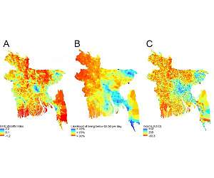
An international team has, for the first time, developed a way of combining anonymised data from mobile phones and satellite imagery data to create high resolution maps to measure poverty.

The researchers, led by WorldPop at the University of Southampton and the Flowminder Foundation, have worked with Telenor Research and mobile phone company Grameenphone to examine rates of poverty and its distribution across Bangladesh - analysing a range of information relating to mobile phone usage. Findings from the study, funded by the Bill and Melinda Gates Foundation, are published in the Journal of the Royal Society Interface.

The team found that by combining mobile data and geospatial data from satellites, they were able to produce poverty predictions which are comparable with those made from traditional sources, but with significant advantages.

Lead author Dr Jessica Steele explains: "Census and household surveys are normally used as data sources to estimate rates of poverty. However, they aren't regularly updated - for example, censuses only take place every ten years - and in low income countries, surveys can be patchy.

"The advantage of using mobile phone data is that it provides us with information which is continually updated, can be interrogated in a variety of ways and can track changes on an ongoing basis. Paired with satellite data that has similar features, it can give a much more dynamic view of poverty and its geographic spread."

Every time a person uses a mobile it sends information to a receiving tower and gives an approximate location of where they are. It also contains information about levels of data usage, numbers of texts sent, times calls were made and their duration. It can reveal how much and how far people are travelling, as well as the type of phone they're using - i.e. basic mobile device, or smart phone.

This kind of anonymised data helps build a picture of poverty. For example, monthly credit consumption on mobiles, and the proportion of people in an area using them, can indicate household access to financial resources - while movements of mobiles and their use of networks provide information on individuals' economic opportunities.

Similarly, remote sensing from satellites can indicate the living conditions of communities. Researchers in WorldPop have, for several years, undertaken research on how data on rainfall, temperature and vegetation reveals information about agricultural productivity, while how far people live from roads and cities and whether they can light their homes may reflect a community's access to markets and information.

Dr Steele adds: "Satellite data can provide us with excellent information about living conditions in rural areas, but in tightly packed cities it's more difficult. It's the reverse for mobiles - more masts in cities means more information, contrasted with the countryside where mobile receiving towers can be thinly spread."

The researchers recognise that some of the very poorest in society may not own a mobile, but even taking this in to account, they were able to identify distinct differences between low income informal settlements and richer areas.

In 2016, the United Nations pledged to '...end poverty in all forms and dimensions by 2030' as part of its Sustainable Development Goals. One of the steps towards achieving this involves targeting the most vulnerable in society.

The researchers are now expanding their work to other countries. They hope their findings can be utilised to track poverty more effectively in the future and provide detailed and accurate information to better inform governments and relief organisations.

Research paper


Comment on this article using your Disqus, Facebook, Google or Twitter login.


Thanks for being here;
We need your help. The SpaceDaily news network continues to grow but revenues have never been harder to maintain.

With the rise of Ad Blockers, and Facebook - our traditional revenue sources via quality network advertising continues to decline. And unlike so many other news sites, we don't have a paywall - with those annoying usernames and passwords.

Our news coverage takes time and effort to publish 365 days a year.

If you find our news sites informative and useful then please consider becoming a regular supporter or for now make a one off contribution.
SpaceDaily Contributor
$5 Billed Once


credit card or paypal
SpaceDaily Monthly Supporter
$5 Billed Monthly


paypal only


.


Related Links
University of Southampton
Earth Observation News - Suppiliers, Technology and Application


Share this article via these popular social media networks
del.icio.usdel.icio.us DiggDigg RedditReddit GoogleGoogle

Previous Report
EARTH OBSERVATION
An application of astronomy to save endangered species
Santa Cruz de Tenerife, Spain (SPX) Feb 07, 2017
Four centuries ago, Galileo began a revolution by pointing his telescope at the sky. Now a multidisciplinary team of astrophysicists and ecologists has reversed the perspective, pointing cameras towards the Earth to help the conservation of endangered species. In this case, the revolution consists of combining the use of unmanned aircraft (drones), equipped with infrared cameras, with detection ... read more


EARTH OBSERVATION
A new recruit for ESA's astronaut corps

The Outer Space Treaty has been remarkably successful - but is it fit for the modern age?

Full Braking at Alpha Centauri

New Era of Space Travel: Private Station May Replace ISS by Late 2020

EARTH OBSERVATION
Commercial Launch of Proton-M Carrier Rocket Planned For Early April - Roscosmos

India to launch record 104 satellites next week

ISRO tests C25 Cryogenic Upper Stage of GSLV MkIII

Russia to call tender for 2nd Phase of Vostochny Spaceport construction in Fall

EARTH OBSERVATION
UAE Aims to Launch Its First Ever Mars Mission in 2020

Opportunity Takes Advantage of her Location to do a Mini Science Campaign

Swirling spirals at the north pole of Mars

Curiosity rover sharpens paradox of ancient Mars

EARTH OBSERVATION
China looks to Mars, Jupiter exploration

China's first cargo spacecraft to leave factory

China launches commercial rocket mission Kuaizhou-1A

China Space Plan to Develop "Strength and Size"

EARTH OBSERVATION
NASA seeks partnerships with US companies to advance commercial space technologies

An exciting year in space for Intelsat

Iridium Adds Eighth Launch with SpaceX for Satellite Rideshare

Space, Ukrainian-style: Through Crisis to Revival

EARTH OBSERVATION
New beam pattern yields more precise radar, ultrasound imaging

Anatomy of a debris incident

Japan's troubled 'space junk' mission fails

New material that contracts when heated holds great industrial potential

EARTH OBSERVATION
Santa Fe Institute researchers look for life's lower limits

Dedicated Planet Imager Opens Its Eyes to Other Worlds

New planet imager delivers first science at Keck

First footage of a living stylodactylid shrimp filter-feeding at depth of 4826m

EARTH OBSERVATION
New Horizons Refines Course for Next Flyby

It's Never 'Groundhog Day' at Jupiter

Public to Choose Jupiter Picture Sites for NASA Juno

Experiment resolves mystery about wind flows on Jupiter


The content herein, unless otherwise known to be public domain, are Copyright 1995-2024 - Space Media Network. All websites are published in Australia and are solely subject to Australian law and governed by Fair Use principals for news reporting and research purposes. AFP, UPI and IANS news wire stories are copyright Agence France-Presse, United Press International and Indo-Asia News Service. ESA news reports are copyright European Space Agency. All NASA sourced material is public domain. Additional copyrights may apply in whole or part to other bona fide parties. All articles labeled "by Staff Writers" include reports supplied to Space Media Network by industry news wires, PR agencies, corporate press officers and the like. Such articles are individually curated and edited by Space Media Network staff on the basis of the report's information value to our industry and professional readership. Advertising does not imply endorsement, agreement or approval of any opinions, statements or information provided by Space Media Network on any Web page published or hosted by Space Media Network. General Data Protection Regulation (GDPR) Statement Our advertisers use various cookies and the like to deliver the best ad banner available at one time. All network advertising suppliers have GDPR policies (Legitimate Interest) that conform with EU regulations for data collection. By using our websites you consent to cookie based advertising. If you do not agree with this then you must stop using the websites from May 25, 2018. Privacy Statement. Additional information can be found here at About Us.