| . |  |
. |
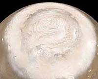
Cameron Park CA (SPX) Jun 22, 2007 Besides the possible "Atmospheric Signatures and Near-Surface Change" mission that I mentioned in my last installment, the "MEPAG" science team assigned to pick possible goals for NASA's big 2013 Mars Science Orbiter proposed two other general types of possible science mission for the craft. One is "Polar and Climate Processes" ("Plan P"). Mars' polar caps are among the most scientifically important parts of the planet. They contain most of the planet's remaining water supply as ice layers kilometers-thick -- and up to fully 25% of Mars' remaining thin carbon dioxide atmosphere freezes out at whichever pole is undergoing winter to form a thin surface layer on top of that, which then re-vaporizes when spring comes. The ''Layered Deposits'' underlying and surrounding them (on which the failed 1998 Polar Lander mission was to touch down) contain hundreds of thin layers of mixed ice and dust. These seem to represent a record of the changes in Mars' climate over the last few million years, as the planet's mildly elliptical orbit has changed slightly in shape, and Mars' "obliquity" (its spin-axis tilt) has -- unlike Earth's -- rocked back and forth over a wide arc of 15 to 35 degrees during cycles of about 120,000 years. The tilt has sometimes been even greater during the earlier past, such as a period ending about 5 million years ago in which the planet's axis may have tilted up to 45 degrees. These changes must have had spectacular effects on Mars' climate, with the polar ice migrating to lower latitudes during the periods of greater tilt (down as close as 30 degrees to the equator during the most extreme periods).At these times, the long exposure of each pole of Mars to continuous sunlight would have thawed out enough frozen carbon dioxide from the polar regions to multiply the planet's air pressure several fold, and perhaps raise both the temperature and air pressure in its polar regions enough for small amounts of liquid water to exist stably on the surface -- possibly even allowing Martian germs frozen in suspended animation in the polar ice to return to life and reproduce before the tilt shrank and the poles refroze. And during the periods when Mars' poles were thus cooling down again, large amounts of water ice -- mixed with dust that had been blown about in the thicker air -- will have refrozen at the poles, forming another layer of the ''Layered Deposits''. But to understand what the 'Layered Deposits' are really telling us about the intensity of the change in Mars' climate during these periods, we have to do two things: measure their thickness, horizontal extent and dust/ice ratios more precisely than we have yet done, and sensitively monitor the seasonal and inter-year effects that Mars' current weather is having on the polar ice layers that now exist. These would be the most important goals of the Plan P mission for MSO. In its barebones "Reduced" version for this particular type of science mission, MSO would (like its reduced version for the previously-mentioned "Plan A" mission), carry a camera capable of photographing wide parts of the Martian surface with a 1-meter resolution as sharp as that of Mars Global Surveyor's camera, but covering much wider areas -- plus a microwave spectrometer that could accurately profile air temperatures, humidity and overall wind speeds in the air above the caps, and an infrared sounder that would compliment it by monitoring dust in the air. (These instruments would also be used to make major observations of the surface and weather of the rest of Mars, and the microwave spectrometer could do a good deal of hunting for interesting trace gases -- as in the Plan A version of MSO.But the big, supersensitive Fourier infrared spectrometer on the Plan A mission, which could detect trace gases down to parts per trillion, would be replaced in this Plan P version by a multi-beam laser altimeter with vastly sharper resolution than the one on Mars Global Surveyor -- capable of monitoring surface heights with an accuracy of just a few centimeters, over widths of just a few hundred [?] meters. While this gadget could of course also provide major new science for the rest of Mars, its main purpose would be to precisely monitor rises and falls in the thickness of Mars' topmost polar ice layers over each year -- and over longer periods. Each pole, as mentioned, combines a kilometers-thick permanent water-ice cap with a topmost layer of CO2 snow that freezes up to 1.5 meters thick each winter and then vaporizes again in spring. And the bigger south polar cap (for reasons we don't entirely understand) also contains an intermediate "residual" (permanent) layer of CO2 ice up to 10 meters thick between those other two layers.Moreover, our recent Mars orbiters have discovered that this residual CO2-ice layer -- when it's exposed to view in mid-summer -- has strange, flat "Swiss cheese" type holes in it that actually seem to be growing steadily in size over the last few years. This indicates that the polar caps are also undergoing changes stretching over decades -- time periods intermediate between each year's CO2 snowfall, and the major tens-of-thousands-of-years climate cycles that Mars undergoes. But we don't understand these intermediate changes at all -- we don't know whether there are times when the southern residual cap vanishes completely and then reappears, and we aren't sure what is causing the changes (although Mars' occasional really huge planet-wide dust storms are suspected as the culprit).Indeed, we don't even know whether the growing Swiss Cheese holes actually represent a drop in the total amount of frozen CO2 polar ice, or whether the CO2 vaporizing out of them just refreezes elsewhere on the polar cap, such as at its edges. Nor do we know yet whether similar decades-long changes may sometimes occur in the exposed surface of the north pole's main water-ice cap. By precisely monitoring the rises and falls in the height of the ice layers -- at the same time that MSO's other instruments monitor the temperature, winds and humidity of the air over the polar regions -- we could get a much sharper understanding of just what kind of effects any particular kind of weather or climate conditions on current-day Mars has on the caps, allowing us to come up with better estimates of the kinds of past climate changes could have laid down the individual layers of the older Layered Terrains. That very sharp laser altimeter could also provide much additional data on just how the layers are actually shaped and what their consistency is, and give us more data on the wider "mantled" regions stretching from the edges of the polar caps down to only 30 degrees latitude where layers of caked dust (and maybe even buried ice) have been laid down during Mars' more spectacular earlier climate excursions. Finally, it could give us a sharp look at the local snowstorms of falling CO2 snow that MGS' laser altimeter detected during the long polar nights of the caps. If NASA can find enough money to fly the bigger "Core" version of MSO, the Plan P mission would also (like the Core version of the Plan A mission) replace that 1-meter camera with a camera as sharp as the HiRISE camera on our current Mars Reconnaissance Orbiter. And it would also replace that simpler infrared climate sounder with a really capable combined near-infrared and thermal-infrared mapping spectrometer, with far sharper sensitivity and surface resolution than the mapping IR spectrometers on MRO and the earlier Mars orbiters. This would allow changes in the surface makeup and brightness of the polar caps (such as their dust content) to be constantly monitored as well to see how that circularly interacts with Mars' polar weather. And this combined "SWIR-TIR" instrument could also continue and improve the high-resolution mapping of Mars' surface mineral composition currently being done by the "CRISM" near-IR mapping spectrometer on MRO, and by the less sharp near-IR and thermal-IR spectrometers on our earlier Mars orbiters.The still bigger, top-of-the-line "Augmented" version of MSO, if this Plan P mission was approved to focus most on Mars' poles, could also carry the same "SAR" radar imaging system suggested for the Augmented version of the Plan A MSO mission. It could make sharp photographic-type images not only of the bedrock formations just below Mars' upper few meters of loose soil, but make similar images of changes in the surface features on the permanent water-ice polar caps (and the intermediate residual CO2 cap layer on the southern pole) at times when they are covered over by the upper layers, as well as providing new data on the structure and dust/ice ratio of the upper few layers of the Layered Terrains. Unfortunately, there's an unavoidable clash between the Plan A and Plan P mission proposals for MSO, having to do with the inclination of its near-polar orbit. To sharply examine the polar caps, we would naturally want the Plan P version of MSO to fly almost directly over the poles, with an orbital inclination less than 5 degrees from a perfect polar orbit. But such a near-polar orbit for the Plan A-type MSO version would seriously reduce the total number and spacing of different solar occultations that its big Fourier IR spectrometer could observe as the orbiter flew between Mars' day and night sides, greatly damaging that instrument's ability to localize (or even find) interesting trace gases.Thus the Plan A MSO, for that central goal, would have to have an orbital inclination of no more than 74 degrees, eliminating its ability to observe more than the edges of the polar caps. In my last installment, I'll describe the third and last general mission type proposed for the 2013 orbiter by the science analysis group -- and some factors that may determine which of the mission types is actually chosen. Bruce Moomaw is our first "Space Blogger" at www.spaceblogger.com Feel free to create an account on SpaceBlogger and discuss this issue and more with Bruce and friends. Email This Article
Related Links
 Cameron Park CA (SPX) Jun 17, 2007
As I noted in a recent story, NASA is continuing to adjust the details of its near-future Mars exploration program -- and it has just taken another step to do so. The latest fine-tuning involves the mission now planned for the 2013 Mars launch window. |
|
| The content herein, unless otherwise known to be public domain, are Copyright 1995-2006 - SpaceDaily.AFP and UPI Wire Stories are copyright Agence France-Presse and United Press International. ESA PortalReports are copyright European Space Agency. All NASA sourced material is public domain. Additionalcopyrights may apply in whole or part to other bona fide parties. Advertising does not imply endorsement,agreement or approval of any opinions, statements or information provided by SpaceDaily on any Web page published or hosted by SpaceDaily. Privacy Statement |