| . |  |
. |
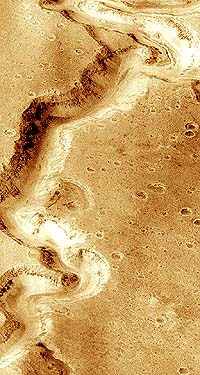
by Bruce Moomaw Cameron Park - March 15, 2000 - However, other geologists are more pessimistic. MGS' close-up photo of the Nanedi Valley has drawn great public attention because it clearly shows a smaller channel running along the bottom of the main water-carved valley -- indicating that water later ran along the surface of the valley floor, even if the initial valley had been carved by subsurface sapping. But Michael Malin and Ken Edgett, in their study, conclude that "Inner channels within other valley networks are extremely rare... In over a thousand [MGS] images of networks, only one other valley [the Nirgal] shows an inner channel." This suggests that prolonged surface water runoff on Mars, while it may have existed in a few places, was very uncommon -- but Malin and Edgett point out that MGS' photos also show that the valley networks have been highly eroded and largely filled up with dust and sand during the billions of years since Mars lost its surface water, which may obscure most evidence of surface runoff. R.M. Williams and R.J. Phillips suggest that there may have been a mixture of the two processes: Mars "would transcend from an early warm phase to the current arid, cold conditions by a freeze-out which moves from pole to equator over a time-scale of a few hundred million years. Thus, the oldest valley networks presumably would form due to surface runoff... As the surface temperature began to drop, the formation mechanism would transition first to water-lubricated sapping and finally to ice-lubricated sapping... Thus the near-equatorial valley networks would continue forming due to [runoff] for a longer period of time than their polar valley network counterparts" -- which they say is in accord with the visible evidence, including the fact that many valley networks seem to share characteristics of the two formation processes. And Pascal Lee makes still another suggestion: that the valley networks resemble northern Canadian channels formed by meltwater trickling along under glaciers. However, for Mars to have had glaciers -- which some authors (including G. Komatsu at the current Conference) have claimed also left recognizable gouges in some of Mars' mountains -- ancient Mars must have had snowfall.
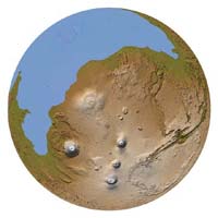
Robert Strom and Victor Baker go further: they have proposed for some time that Mars, throughout its history, may have had volcanic outbreaks every few tens or hundreds of millions of years that have thawed enough frozen water and carbon dioxide in the soil to briefly restore its original dense atmosphere and northern ocean, even into fairly recent geological times. They repeated that theory at this conference. Regardless of the truth of that, the Borealis Ocean (perhaps ice-covered) may at least have existed during Mars' ancient days, and several Conference speakers claimed additional evidence of that.
And, as other speakers (such as M.A. Kreslavsky and J.B. Garvin) pointed out, the floors of Mars' northern lowlands have turned out to be astonishingly smooth, further suggesting that they may have been covered with a layer of ocean-floor sediment at one time. Again, though, there are alternative theories: K.L. Tanaka and William Banerdt suggested that the apparent lack of shorelines of this "ocean", and some odd features of its seafloor altitude, indicate that it may have been an ocean not of water, but of sediment-rich mud.
|
| ||||||||||||
| The content herein, unless otherwise known to be public domain, are Copyright 1995-2016 - Space Media Network. All websites are published in Australia and are solely subject to Australian law and governed by Fair Use principals for news reporting and research purposes. AFP, UPI and IANS news wire stories are copyright Agence France-Presse, United Press International and Indo-Asia News Service. ESA news reports are copyright European Space Agency. All NASA sourced material is public domain. Additional copyrights may apply in whole or part to other bona fide parties. Advertising does not imply endorsement, agreement or approval of any opinions, statements or information provided by Space Media Network on any Web page published or hosted by Space Media Network. Privacy Statement All images and articles appearing on Space Media Network have been edited or digitally altered in some way. Any requests to remove copyright material will be acted upon in a timely and appropriate manner. Any attempt to extort money from Space Media Network will be ignored and reported to Australian Law Enforcement Agencies as a potential case of financial fraud involving the use of a telephonic carriage device or postal service. |