| . |  |
. |
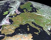
Brussels (ESA) Feb 21, 2005 Around 60 nations and more than 40 international organisations joined ESA and host, the European Community, at the Third Earth Observation summit last Wednesday. History was made at the Palais d'Egmont in Brussels as assembled delegates formally agreed on a ten-year plan to implement a Global Earth Observation System of Systems. The plan summarises the steps that need to be taken to put a Global Earth Observation System of Systems (GEOSS) in place. GEOSS will build on existing Earth Observation systems by coordinating efforts, addressing data gaps and supporting interoperability and information sharing. It aims to increase responsiveness to user needs and improve information delivery to users. The creation of a single, comprehensive and sustained system for Earth Observation should help countries to identify and address global environmental and economic challenges, including climate change and natural disasters � the agreement coming on the same day that the Kyoto Protocol entered into force, and just under two months after the Indian Ocean tsunami disaster. Delivering the opening address, European Commission (EC) Environmental Commissioner Stavros Dimas said that a combination of different Earth Observation systems is needed to study the kind of complex phenomena found within the Earth system: "Good policy needs good science � we need to understand the environment in order to protect it. "It is very fitting that we are today, on the date of entry into force of the Kyoto Protocol, launching a system that will greatly enhance our understanding of the environment and will hopefully help us to do what we can to improve it." Kusmayanto Kadiman, Indonesian State Minister for Research and Technology, described his 220-million person nation as "both threatened and blessed by nature�, with the vast archipelago both rich in resources but also subject to a variety of hazards including earthquakes and volcanoes, forest fires, hurricanes and floods as well as the recent tsunami that struck Sumatra and Banda Aceh on 26 December 2004. Kadiman said he was overwhelmed by the response of the world community, including near-real time satellite imagery provided through the Charter on Space and Major Disasters, which enabled the government to swiftly grasp the full scope of the tragedy. "The effectiveness of Earth Observation has been demonstrated," Kadiman said. He added that Indonesia is setting up a Regional Centre for Disaster Mitigation, planned as part of a global network of such centres. "Early-warning systems are required to guard against future disasters, so GEOSS could not be more timely." US Commerce Secretary Carlos Gutierrez reminded the Summit that it had been just 19 months since the First Earth Observation Summit in Washington DC. A lot of work had been done to reach this stage, but the benefits would be worth it: "Hurricane prediction has already saved the lives of many people, keeping our citizens out of harm's way. A third of the US economy is weather or climate-related � a figure amounting to 3 trillion dollars. "Just imagine with GEOSS, farmers being able to predict their crop yields, or identifying the areas most sensitive to forest fires, having weather forecasts with an accuracy of months instead of days, and zeroing in on our climate with complete accuracy." GEO Co-chair Rob Adam, Director-General of the South African Department of Science and Technology, welcomed the GEOSS implementation plan, stating that its emphasis on capacity-building will particularly help sustain and extend the observational capacities of developing countries. Colonel Benjamin Ndala, Secretary-General of the International Commission of the Congo-Oubangi-Sangha Basin (CICOS) gave an example of how capacity-building works in practice. Starting in 1996, a project called PUMA ensured that 53 African national meteorology services would be capable of making use of the enhanced data and services provided by the new Meteosat Second Generation (MSG) family of European weather satellites. Supported by �11 million from the European Commission, as well as bilateral contributions from the Belgium, France and the UK, PUMA has set up a total of 59 receiving stations across the African continent � one for each participating country and six regional centres � and 350 technicians will have been trained by September of this year. He added that the PUMA Task Team is now working on a follow-up project called African Monitoring of the Environment for Sustainable Development (AMESD), that extends beyond meteorology to cover Earth Observation capacity-building, with the intention of providing support for African policy makers. AMESD will serve as the African link to GEOSS. Stephen Briggs of ESA's Earth Observation Science and Applications Department gave details of a programme called TIGER which is focused on applying Earth Observation to Africa, with a particular focus on water management issues � some 95 research proposals have been received across the continent. Satellite radar images are being used to calculate rates of water extraction from underground aquifers, for example, based on millimetre-scale measurements of ground motion. Alan Belward of the EC's Joint Research Centre in Italy stated that the JRC's Africa Observatory project aims to supply Earth Observation data to African users. Belward had a graphic example of how Earth Observation can work in practice � he compared a 1963 declassified military satellite image of Lake Chad to a view from 2000, showing that it is now only a tenth the size it was forty years ago. Shortages of water and other resources are increasing drivers of regional conflicts. Developing countries are disproportionately threatened by climate change, he said. But Earth Observation can enable wise stewardship of resources such as water, forestry and national parks � valuable in themselves as tourist attractions, but threatened by illegal logging and poaching. "The environment and poverty reduction fit hand in glove," Belward said. "Natural resources equal income in developing countries. Poor management of natural resources now can limit their value for future generations - decreasing biodiversity limits the value of ecosystem services." Mosibudi Mangena, South Africa's Minister of Science and Technology said he was very pleased to have GEOSS established, and that the developing world was so well represented: "We will be able to generate data and also get data on a worldwide basis, to use it in our own countries in action against poverty and the other issues that affect humanity. "For developed countries the GEOSS challenge is to coordinate many existing systems, while we in many cases still have to create our own Earth Observation systems. We welcome GEOSS and hope it will bring future generations a better health than our own." Related Links Tiger Initiative SpaceDaily Search SpaceDaily Subscribe To SpaceDaily Express
 Greenbelt MD (SPX) Feb 18, 2005
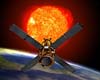
A great mystery was set in motion a few years ago when a spacecraft designed to measure gamma-ray bursts - the most powerful explosions in the Universe - found that Earth was actually emitting some flashes of its own. |
|
| The content herein, unless otherwise known to be public domain, are Copyright 1995-2006 - SpaceDaily.AFP and UPI Wire Stories are copyright Agence France-Presse and United Press International. ESA PortalReports are copyright European Space Agency. All NASA sourced material is public domain. Additionalcopyrights may apply in whole or part to other bona fide parties. Advertising does not imply endorsement,agreement or approval of any opinions, statements or information provided by SpaceDaily on any Web page published or hosted by SpaceDaily. Privacy Statement |