| . |  |
. |
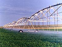
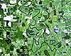
Seattle - Jun 04, 2003 Ranchers, farmers, loggers and recreationalists throughout the West are being asked to share range-lands. With more groups using Western rangelands, it has become increasingly important to monitor the land to maintain it and to guard against overuse. The Bureau of Land Management has been tasked by Congress with reporting the conditions and changes on the land it manages�all 262 million acres of it. Pacific Northwest National Laboratory researchers have developed a unique way of applying remote sensing capabilities to monitor these rangelands. "It sounds like a clich�, but it's true," said PNNL's Larry Cadwell, who managed the project. "We were challenged to do it better, faster and cheaper." The BLM asked PNNL to find a cost-effective and easy-to-use way to sample BLM lands, locating areas of management concern such as bare soil. Remote sensing tools, including low-level aerial photography and digital imagery from satellites, were the logical choice for cost-effective monitoring. "Each pixel of a remote sensing image gives a spectral signature for that area on the ground, and when you have a change in vegetation cover resulting from some disturbance, that change is reflected in the spectral signature," Cadwell said. Finding where the spectral signature differs from the expected or normal pattern of the site helps identify areas of overgrazing, weed invasion or fire damage. Researchers considered using Landsat satellite imagery because it's fast and can capture eight million acres in a single scene. But eight million acres of rangelands are so diverse that isolating small changes in spectral signature related to land use is nearly impossible. So using available soil and vegetation data, analysts stratified the imagery by dividing the landscape into similar areas according to soil type, vegetation and slope. "Once we have homogenous areas and look at the spectral data for those individual areas, it's much easier to detect a change or abnormal condition," Cadwell said. PNNL analysts applied statistical techniques to analyze the spectral information from homogenous areas to detect anomalous areas or "hot spots." Analysts envision the ultimate product as a web-based system where BLM land managers and ranchers could view maps of land conditions and areas of concern. By entering location data, they could pinpoint extreme amounts of vegetation cover or exposed soils. Over time, users will see trends, such as more invasive weeds or increased soil erosion. PNNL is using these techniques to help the BLM manage fuel accumulations in the dry rangelands of southern Idaho. In arid and semi-arid regions, vegetation is less dense and often dormant through the summer and fall. Vegetation maps derived from satellite imagery may be inaccurate because the spectral response mainly reflects soils. PNNL's methods for detecting subtle differences in spectral responses allow better mapping of salt desert and shrub-steppe vegetation for fuels analyses. Related Links Pacific Northwest National Laboratory SpaceDaily Search SpaceDaily Subscribe To SpaceDaily Express
 Washington - Jun 04, 2003
U. S. Department of Agriculture (USDA) Secretary Ann M. Veneman and NASA Administrator Sean O'Keefe today launched a partnership that will use Earth Science technologies to enhance the competitiveness of American farmers and ranchers and help protect the environment. |
|
| The content herein, unless otherwise known to be public domain, are Copyright 1995-2006 - SpaceDaily.AFP and UPI Wire Stories are copyright Agence France-Presse and United Press International. ESA PortalReports are copyright European Space Agency. All NASA sourced material is public domain. Additionalcopyrights may apply in whole or part to other bona fide parties. Advertising does not imply endorsement,agreement or approval of any opinions, statements or information provided by SpaceDaily on any Web page published or hosted by SpaceDaily. Privacy Statement |