| . |  |
. |
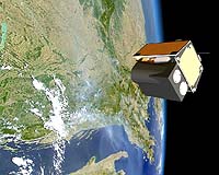
Plesetsk, Russia (SPX) Oct 28, 2005 TopSat, the low cost micro-satellite designed and built by a QinetiQ-led consortium of British companies, was successfully launched for the first time this morning from the Plesetsk launch site in Northern Russia. The 07:52 BST launch was the culmination of a programme that began in 2000 and which is jointly funded by the British National Space Centre (BNSC) and the UK Ministry of Defence. TopSat, which is attracting increasing interest from international government and commercial customers alike, is designed to provide 2.5 metre resolution imagery at much reduced cost to larger satellites. Typically, current generation imaging satellites with a comparable performance will cost in excess of five times more than TopSat. The system addresses many remote sensing applications including disaster relief, environmental monitoring, crop management, land use, border control and security use. Lord Sainsbury, DTI Minister with responsibility for the BNSC and UK space policy, welcomed the news of the successful launch, saying: "TopSat is a British success story and I congratulate QinetiQ and all of the TopSat partners on their achievement. TopSat has significant commercial potential and demonstrates the UK's leadership in the emerging market for smaller, low-cost, high performance satellites." "Today's successful launch is a great achievement for the TopSat team," said Bill Levett, TopSat Project Manager at QinetiQ. "We now look forward to the next important milestone when we start to collect valuable earth observation data and begin to provide our customers with the benefits of what is probably the world's best performance to cost ratio for any imaging satellite." Leading the consortium of UK companies in TopSat's development, QinetiQ's role has been both in overall systems design and programme management. QinetiQ also provided the major payload electronic sub-systems. Other partners in the project include Surrey Satellite Technology Ltd which developed the platform, satellite integration and the telecommand and control system. CCLRC Rutherford Appleton Laboratory (RAL) provided the high performance camera and Infoterra Ltd is developing the market for TopSat data products. Once deployed QinetiQ will work closely with customers to manage operations, including the direct reception of data in the field using a fully mobile, rapidly deployable low cost data ground station, known as RAPIDS. Using RAPIDS QinetiQ can provide an independent, low latency, low cost and versatile imaging capability to meet commercial and other user community needs.
The technology The first of its kind in the UK, TopSat is a low cost small satellite which will provide local users in-situ on the ground with high-resolution imagery. It consists of an advanced optical camera, which is able to collect 17 x 17 km images of the earth with a panchromatic (black and white) resolution of 2.5 metres and a multispectral (colour) resolution of 5 metres. This is integrated with an agile micro-satellite to permit Time Delay Integration, allowing imaging of low illumination scenes. TopSat aims to deliver imagery direct to users via a mobile ground station, from a low Earth orbit in near real-time. Data can also be downloaded to other mobile or fixed ground stations using the CCSDS communications standard within hours, increasing the versatility of the system. With future development, a constellation of three or four TopSat satellites could image almost any point on the Earth at least once a day, subject to cloud conditions, opening up the potential for very low latency imagery which is extremely cost effective to deliver. TopSat is one of three satellite projects funded under the MOSAIC programme (the BNSC Small Satellite Programme). The programme is intended to fully exploit the UK's world leading capability in small satellites and to stimulate the development of key small satellite technologies and payloads. Related Links QinetiQ SpaceDaily Search SpaceDaily Subscribe To SpaceDaily Express
 Plesetsk, Russia (SPX) Oct 28, 2005
Thursday morning at 08:52 CEST, a COSMOS-3M carrier carrying a multinational payload was launched on schedule. The rocket took off at the Plesetsk launching pad located 800 kilometers north-east of Moscow, successfully placing the RUBIN-5 microsatellite developed by OHB as well as other payloads in orbit. |
|
| The content herein, unless otherwise known to be public domain, are Copyright 1995-2006 - SpaceDaily.AFP and UPI Wire Stories are copyright Agence France-Presse and United Press International. ESA PortalReports are copyright European Space Agency. All NASA sourced material is public domain. Additionalcopyrights may apply in whole or part to other bona fide parties. Advertising does not imply endorsement,agreement or approval of any opinions, statements or information provided by SpaceDaily on any Web page published or hosted by SpaceDaily. Privacy Statement |