
The issue is that many popular cloud service providers aren't compatible with 3D files. That means in order to preview a 3D scan, users need to download the files onto a desktop 3D app - for example, the app for popular computer-aided design software AutoCAD. It also makes collaborating on 3D files difficult unless people are huddled around the same computer.
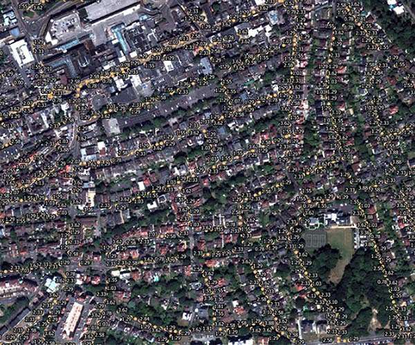
Now Stitch3D, founded by Clark Yuan MBA '22, is helping workers get the most out of 3D data with a cloud platform that allows users to manage, analyze, and share 3D files of any size and format. The company's suite of tools lets workers collaborate on 3D files, visualize their data on any browser or mobile device, and even layer 3D scans onto real-world maps.
"Think of Stitch3D as three different layers of technology," Yuan says. "The base layer is similar to DropBox - a secure way to share files. On top of that we have a web browser-based 3D viewer that can render 3D data efficiently and apply analysis to that. We can measure distance, height, slope angle, volume, etc. The third layer, which is coming out later this year, is a mobile application that allows you to tap into any smartphone that has light detection and ranging (lidar) sensors embedded into it."
Stitch3D is currently working with land and aerial surveyors, architects, and construction firms. In the longer term, Yuan believes 3D data is poised to go mainstream. That's because 3D sensors continue getting cheaper and more ubiquitous, which should bring a wave of new 3D use cases.
"We see so many enabling technologies coming up around 3D data," Yuan says. "Our bet is that in the next one to three years, 3D data is really going to start taking off."
Tech with a mission
On July 12, 2020, the U.S. Navy's USS Bonhomme Richard ship caught fire and burned for four days in a San Diego port. In order to investigate the fire and assess the damage, the Navy conducted 3D scans of the ship. But officers had no easy way of sharing the scans with other agencies.
Yuan, who served in the U.S. Army for seven years until 2019, was among the people the Navy asked to help. He first went through an accelerator with the Navy in 2020, where he formulated the idea for a cloud-based 3D sharing system. In September of that year, he entered the MBA program at the MIT Sloan School of Management, where he took as many entrepreneurship classes as he could.
"I had two years at MIT to mature the idea," Yuan recalls.
During that time, he received guidance from the Venture Mentoring Service (VMS), participated in the MIT $100K Pitch Competition, and received financial support from MIT Sandbox.
"The Sandbox funding was huge because we could put it toward building prototypes and cloud computing services," Yuan says. "As far as I know, no other school has that kind of structured program where you can pitch your idea and apply for nondilutive funding."
Yuan also participated in the Industrial Liaison Program's (ILP) Startup Exchange (STEX) accelerator, which gave him some important industry connections early on.
The year of the USS Bonhomme Richard fire, 2020, was also the year the iPhone 12 debuted as the first phone equipped with a lidar sensor. In the years since, the costs of 3D sensors and the things that carry them, like specialized cameras and drones, have continued to fall, making 3D data generation simple. Yuan sees the trend as an opportunity for the industry.
"The value of 3D is slowly being recognized in the consumer world, whether for going to IKEA to scan a couch and see if it fits in your living room or using a virtual reality headset, there's just so much you can do with 3D data."
Helping 3D data go viral
Stitch3D's platform can create 3D models from scans instantly and provide a number of high-end analytics useful for different industries. Surveyors, for instance, wanted Stitch3D's platform to provide measurements and angles from their scans. Stitch3D can also connect 3D data to satellite imagery from sources like Google Earth to provide context and points of reference. The platform can also visualize feature classes like buildings, vegetation, and water.
"We're not just helping with sharing and viewing 3D files," Yuan says. "We're also trying to help derive business insights from the data. We see these easy-to-use yet powerful analytics tools as a key driver of our long-term success once [large cloud platforms] start focusing on 3D data."
Stitch3D began by working with land surveyors, who have been using 3D technology for decades, but it has since gotten interest from law enforcement agencies, insurers, and construction firms in addition to its work with the U.S. Navy, Air Force, and Department of Defense. Yuan believes the number of industries it works in will continue to grow as 3D data becomes more common.
"Once sharing 3D data becomes as easy as sharing a URL link, which you can embed in an email or a LinkedIn post, we hope that our technology will help accelerate the proliferation of 3D data," Yuan says.
In the longer term, as 3D data matures, Yuan believes the sky's the limit for the industry.
"The cool thing about 3D, and what gets us excited, is that really anything that you take a photo or a video of right now, you can substitute with 3D," Yuan says. "Right now, people are taking tons of pictures for every traffic accident, crime scene, etc. But if you can go in and quickly do a laser scan, which might only take two minutes, you don't have to worry about missing a picture or needing to zoom into some specific video frame to get all the details. If you're talking about traffic accidents, that means emergency responders can focus on responding to the emergency rather than trying to preserve and document evidence for insurance purposes."
Related Links
MIT Sandbox
Earth Observation News - Suppiliers, Technology and Application
| Subscribe Free To Our Daily Newsletters |
| Subscribe Free To Our Daily Newsletters |