| . |  |
. |
| . | |
. |
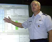
Washington - Feb 21, 2003 A new technology designed to save time and reduce errors in air warfare planning will make its debut in Southwest Asia - if the United States moves to disarm Iraq. The master air attack plan toolkit is a Web-based software application developed to help war planners in an air operations center produce a master air attack plan. The MAAP is the foundation for the air tasking order - essentially the marching orders for fighter, attack and bomber aircraft in theater. In years past, computers have played a more extensive role in the process of producing the MAAP. But largely, the process still involved a lot of manual information shuffling - grease pencils and transparencies, paper maps and printouts. The process, said the commander of the Air Force's Command and Control Battlelab at Hurlburt Field, Fla., was daunting. "The idea for this started with the Persian Gulf War and with Bosnia while preparing the master air attack plan," said Col. Jon Krenkel. "That process was very manual and very labor intensive. You would have to take a complete set of targets and a complete set of assets including airplanes available, the munitions that they had, where they were coming from, where they had to go to, and try to tie all that together in a coherent logical manner." The battlelab is a small technical community responsible for finding innovative ways to improve Air Force command and control support of joint operations. According to Krenkel, the lab developed the MAAP toolkit in response to the difficulties of creating it manually. "What we have done is take a software tool called the Web Enabled Temporal Analysis System and added some business rules," Krenkel said. "That enabled us to do everything that used to be done by hand and with yellow 'stickies,' and do it instead with a computer." The toolkit looks into existing real-time databases provided by other AOC cells. Those include, among other things, weather information, theater maps, lists of available aircraft, lists of available munitions and lists of potential targets provided by the intelligence, surveillance and reconnaissance communities. These databases are updated continuously and the MAAP toolkit produces a near real-time visual representation of them on screen. In a typical scenario, Krenkel said, the toolkit might display a map of the theater. Using a list of coordinates provided by the ISR community, the toolkit would highlight those targets on the map. To the side would be separate windows containing lists of available aircraft and available munitions. Beneath the map would be another window displaying "packages" - pairings of multiple aircraft with select munitions. Planners use the MAAP toolkit to build packages by dragging and dropping assets, aircraft and munitions from one menu to the other, Krenkel explained. Then they can assign packages, a time and a target. As a target is assigned to a package, its color changes on the map. As aircraft are assigned to a package, their numbers are deducted from the availability lists. One benefit of the MAAP toolkit is that it eliminates the potential for errors, said Lt. Col. Douglas Combs, chief of concepts execution division for the battlelab. "You are basically taking the human out of the loop," Combs said. "You don't have the opportunity for error, you are just manipulating (data), putting it into a different package and sending it on its way. If it is correct in the database, then it is correct on the other end." Besides reducing errors, the speed at which the MAAP can be completed is also improved, Combs said. "That's what we realized at 2002 Joint Expeditionary Forces Experiment at Nellis Air Force Base, (Nev.)," Combs said. "We were able to take a 24-hour cycle, 12 hours for MAAP and 12 hours for ATO production, and run them concurrently. Pretty much by the end of the exercise we were getting them done in, from start to finish, around eight hours." The process of reviewing the final MAAP to ensure it is really what war planners were looking for is also improved by the MAAP toolkit, he said. The toolkit allows users to watch the entire plan unfold like a film, Combs said. Animated aircraft on the screen move slowly across the map toward their target. Each is "launched" to coordinate with their scheduled takeoff times and moves across the screen in sync with all the other aircraft. Additionally, each moves at a speed commensurate with its real-world speed. Planners can watch their plan played out on screen before it is turned into an ATO and sent out to units. Krenkel said he believes it will perform equally well in a real world situation as it did at the JEFX. "This (use in Southwest Asia) would be first time this system will be used in an actual combat situation," he said. "But we are confident it will perform well if the need arises." Related Links SpaceDaily Search SpaceDaily Subscribe To SpaceDaily Express
 Washington - Feb 21, 2003
 |
|
| The content herein, unless otherwise known to be public domain, are Copyright 1995-2006 - SpaceDaily.AFP and UPI Wire Stories are copyright Agence France-Presse and United Press International. ESA PortalReports are copyright European Space Agency. All NASA sourced material is public domain. Additionalcopyrights may apply in whole or part to other bona fide parties. Advertising does not imply endorsement,agreement or approval of any opinions, statements or information provided by SpaceDaily on any Web page published or hosted by SpaceDaily. Privacy Statement |