| . |  |
. |
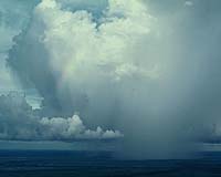
Huntsville AL (SPX) Feb 15, 2006 A new way of analyzing data from weather satellites may soon help pilots avoid flying through rain or turbulence from convective thunderstorms, according to a UAH scientist. Working with colleagues at UAH, the University of Wisconsin and NASA's Langley Research Center, Dr. John Mecikalski, an assistant professor of atmospheric science, has developed a system that is about 65 percent accurate in giving a one-hour warning before heavy rain starts to fall within a thunderstorm. "Our goal is to take existing, real-time satellite instruments and predict aviation hazards due to thunderstorms and severe weather," said Mecikalski. "NOAA is evaluating our tool, the FAA is testing it and the Huntsville National Weather Service office used it this past summer." Results of this research were published in the January edition of the journal "Monthly Weather Review" and will be presented at the annual winter meeting of the American Meteorological Society in Atlanta. The new forecasting system uses both visible and infrared images taken by NOAA's GOES and NASA's MODIS satellites. By merging the visible and infrared data, the forecast model gets new cloud top temperature readings every 15 minutes. Cumulus clouds that get colder from one reading to the next are building; cloud tops that get significantly colder are building rapidly. "Not only can you tell if a cloud is getting deeper, you can also tell if the top has turned from water droplets to ice, which has implications for lightning formation," Mecikalski said. by giving a warning as much as an hour in advance, the system can help airline and private pilots take evasive action before a thunderstorm becomes violent. This not only improves safety and comfort, it also improves efficiency and can help save money. In addition to helping pilots avoid problems caused by flying through violent storms, the new system can also help warn of possible turbulence above storms and downwind from mountain ranges. Wind blowing over the tops of either mountains or billowing cloud tops can create a "wave" or rotor effect. Air being forced upward as it blows over mountains or storms creates low pressure on the back side of the obstacle, which pulls the air into sometimes powerful downdrafts. This up-and-down airflow can create a turbulent wave pattern that will continue downwind. If this turbulence is in clear air, it is invisible to the human eye and can't be detected by Doppler radar. These waves, however, can be seen by the satellite sensors, says Mecikalski. "When one of these waves breaks like it does on a beach, that's when you can have a problem for aviation. It acts like a wave on a beach, but it's invisible. The satellites let you see these phenomenon." The satellite infrared sensors "see" these waves because rising air cools while sinking air warms, creating alternating bands of warmer and colder infrared radiation. One advantage of using satellite information is that it is available over most of the globe, so it might be used to provide hazard warnings over areas not covered by Doppler or aviation radar systems. In addition to studying turbulence and convective storms, Mecikalski and his colleagues are also developing techniques for using satellite data to detect and warn of volcanic ash in the atmosphere, and of possible icing conditions. Related Links University of Alabama
 Geneva (AFP) Feb 07, 2006
The lives of around 1.5 million youngsters in the drought-stricken Horn of Africa are at risk, the United Nations Children's Fund (UNICEF) warned Thursday. |
|
| The content herein, unless otherwise known to be public domain, are Copyright 1995-2006 - SpaceDaily.AFP and UPI Wire Stories are copyright Agence France-Presse and United Press International. ESA PortalReports are copyright European Space Agency. All NASA sourced material is public domain. Additionalcopyrights may apply in whole or part to other bona fide parties. Advertising does not imply endorsement,agreement or approval of any opinions, statements or information provided by SpaceDaily on any Web page published or hosted by SpaceDaily. Privacy Statement |