| . |  |
. |
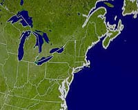
Kingston RI (SPX) Nov 24, 2005 Two University of Rhode Island researchers have been awarded an $86,000 grant from FM Global to create maps of the East Coast of the U.S. that will identify potential flooding and damage that could occur if a tsunami struck the region. Ocean engineering professors Stephan Grilli of Narragansett and Christopher Baxter of Cranston will study historical events and evaluate the risks and probabilities of a tsunami striking anywhere on the East Coast from the Carolinas to Maine. "FEMA [the Federal Emergency Management Agency] has worked on hazard maps for the West Coast and Hawaii for years, but none have been made for the East Coast," Grilli said. "That's partly because there is a lower risk for tsunamis in the Atlantic, but also because they're more complicated to predict." A tsunami in the Pacific Ocean would likely be caused by an underwater earthquake that quickly raises or lowers part of the seafloor, according to Grilli, and the resulting wave created by such an event is relatively easy to predict. Tsunamis in the Atlantic Ocean are more likely to be caused by underwater landslides near the continental shelf, and predicting how large a wave this would generate is more difficult. Grilli and Baxter will use GIS (Geographic Information Systems) maps to study the accumulations of sediment on the upper slope of the continental shelf that may be unstable and could potentially slide and cause a tsunami. By assessing the nature and weight of the sediment, its cohesiveness, and the angle of the slope it sits on, the URI scientists can determine the probability of a landslide. They are particularly interested in an area off the New Jersey coast and another on the Grand Banks off Nova Scotia, where a major tsunami was triggered in 1929. "An earthquake with a magnitude of 6.0 isn't strong enough to cause a tsunami, but it certainly could cause an underwater landslide that could cause a tsunami, and the earth has about 120 earthquakes of that size every day," Grilli said. FM Global is funding the research to gain further understanding about the potential size of a tsunami and the likelihood of one occurring. Additionally, the research results will enhance FM Global's and its clients' abilities to make even more informed risk management decisions. Related Links University of Rhode Island SpaceDaily Search SpaceDaily Subscribe To SpaceDaily Express
 London UK (SPX) Nov 24, 2005
A UK e-Science project is revealing new scientific insights into earthquakes. Technologies developed under the Discovery Net project are enabling geophysicists to combine two different methods of studying earthquakes and so discover new knowledge that would not have been revealed using one method alone. |
|
| The content herein, unless otherwise known to be public domain, are Copyright 1995-2006 - SpaceDaily.AFP and UPI Wire Stories are copyright Agence France-Presse and United Press International. ESA PortalReports are copyright European Space Agency. All NASA sourced material is public domain. Additionalcopyrights may apply in whole or part to other bona fide parties. Advertising does not imply endorsement,agreement or approval of any opinions, statements or information provided by SpaceDaily on any Web page published or hosted by SpaceDaily. Privacy Statement |