| . |  |
. |
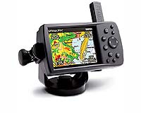
Olathe KS (SPX) Jul 20, 2005 Garmin International, a unit of Garmin announced Tuesday the GPSMAP 376C - a highly versatile and portable GPS navigator that can display graphical XM WX Satellite Weather data directly on the unit's display. "The addition of XM WX Satellite Weather provides another dimension of situational awareness and safety to our popular line of multi-purpose GPS navigators," said Gary Kelley, Garmin's director of marketing. "Whether they're navigating open waters or the open road, the GPSMAP 376C offers the most detailed and up-to-date weather information available - to help users make informed navigational decisions." The GPSMAP 376C can overlay vital weather data directly on the display - information like NEXRAD radar, storm cells, wind speeds, surface temperatures, forecasts, and more than a dozen other weather attributes. The weather data is the same leading site-specific, analytical weather technology and data that is provided to professional meteorologists across the United States. In addition, mariners and motorists will have the option of receiving XM Satellite Radio's 150-plus channels of commercial-free music, sports, news, talk, and entertainment programming. The GPSMAP 376C includes an audio output jack that allows users to wire XM audio and turn-by-turn navigational voice prompts directly into their vehicle's audio system. XM Satellite data and audio is delivered to the GPSMAP 376C through Garmin's new GXM 30 smart antenna, which is included with the 376C package. The GXM 30, roughly three inches in diameter, processes all weather information and sends the finished data to the GPSMAP 376C for display. "With the industry-leading GXM 30 smart antenna, Garmin is the first to integrate the XM WX Satellite Weather capability with a fully portable GPS navigator - and also deliver the XM Radio audio service from the same device," said Roderick MacKenzie, XM's VP of Advanced Applications and Services. "This is a cutting-edge - yet affordable - product that provides the user with an unmatched combination of mobile situational awareness, information and entertainment both on the water and on land." The GPSMAP 376C boasts an enhanced high-resolution 256-color sunlight readable TFT display. For map transfer or software updates, the unit features a fast USB-PC interface. An included 12-volt power/data cable, a 110-volt wall outlet, or a rechargeable lithium-ion battery pack (providing 4-15 hours of battery life, depending on backlight setting and XM usage) powers the unit. The GPSMAP 376C comes pre-loaded with the Americas Autoroute basemap with tide data, and accepts pre-programmed or user programmed data cards with MapSource BlueChart or Recreational Lakes with Fishing Hot Spots. When on the road, users can load the GPSMAP 376C with MapSource City Select software for voice-prompted turn-by-turn directions to addresses and points of interest throughout the United States and Canada. In addition, the GPSMAP 376C can also receive sonar data through the GSD 20, Garmin's "black box" sounder, which offers 4,000 watts of power peak-to- peak (500 watts RMS) in a dual-frequency transducer (purchased separately). Standard accessories include the GXM 30 smart antenna, an adjustable marine mount, power/data cable, USB-PC interface cable, audio cable, AC adapter, rechargeable lithium-ion battery pack, Trip and Waypoint Manager CD- ROM, user's manual, and a quick start guide. The GPSMAP 376C and included GXM 30 antenna are expected to be available in August 2005 at an expected street price of $999.99. An optional automotive kit including a fully unlocked MapSource City Select CD-ROM, a 128MB data card, 12-volt power adapter with speaker, friction mount, and automotive mount sells for $249.99 (MSRP). XM WX Satellite Weather data and audio is provided by XM Satellite Radio. Related Links Garmin SpaceDaily Search SpaceDaily Subscribe To SpaceDaily Express
 Olathe KS (SPX) Jul 18, 2005
Garmin International, a unit of Garmin has introduced the StreetPilot i2 and i3, a new line of small, inexpensive automotive GPS navigators that make driving fun. |
|
| The content herein, unless otherwise known to be public domain, are Copyright 1995-2006 - SpaceDaily.AFP and UPI Wire Stories are copyright Agence France-Presse and United Press International. ESA PortalReports are copyright European Space Agency. All NASA sourced material is public domain. Additionalcopyrights may apply in whole or part to other bona fide parties. Advertising does not imply endorsement,agreement or approval of any opinions, statements or information provided by SpaceDaily on any Web page published or hosted by SpaceDaily. Privacy Statement |