| . |  |
. |
| . | |
. |
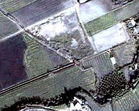
Longmont CO (SPX) May 22, 2006 DigitalGlobe's Canadian business partner, MDA's Geospatial Services, has entered into a contract to provide over 120,000 square kilometers of QuickBird satellite imagery to the Ontario Ministry of Natural Resources. The imagery will be used to support the Land Information Ontario project, which assists government agencies and the public to easily locate, access and use geographic information about the province of Ontario. Land Information Ontario was initiated in 1999 to coordinate geospatial activities in Ontario and to create an infrastructure that supports the province-wide sharing of geospatial data. The system comprises a collection of tools including the Directory, a library card catalogue of geospatial data; the Warehouse, a repository storing spatial and non-spatial data; and the Ontario Geospatial Data Exchange, a data sharing mechanism. Multiple Canadian provincial and local government agencies will use geospatial information extracted from DigitalGlobe's 60-centimeter resolution QuickBird satellite images for source-water protection, conservation, municipal planning, land cover classification, environmental change detection, habitat land planning, coastal wetland mapping, and emergency response applications. DigitalGlobe's satellite imagery will be collected by the QuickBird satellite over a two- to three-year period, and will cover areas of land in eastern, central and selected northern areas of Ontario. MDA's Geospatial Services is able to offer DigitalGlobe's imagery to the Government of Ontario for use by multiple agencies through DigitalGlobe's flexible licensing model, which allows QuickBird imagery products, imagery services and derivative work and mapping products to be used and shared among all provincial and local government users. "The acquisition of DigitalGlobe's imagery is an excellent demonstration of how collaborative efforts within the public sector can benefit a wide variety of business areas," said Brian Maloney, director of the Geographic Information Branch with the Ontario Ministry of Natural Resources. "Through a partnership model, multiple levels of government pooled funding in order to gain access to current, high-quality geospatial data that can facilitate numerous initiatives throughout the Province of Ontario."
Related Links DigitalGlobe
 Paris, France (SPX) May 23, 2006
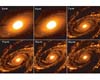
AKARI, the new Japanese infrared sky surveyor mission in which ESA is participating, saw 'first light' on 13 April 2006 (UT) and delivered its first images of the cosmos. The images were taken towards the end of a successful checkout of the spacecraft in orbit. |
|
| The content herein, unless otherwise known to be public domain, are Copyright 1995-2006 - SpaceDaily.AFP and UPI Wire Stories are copyright Agence France-Presse and United Press International. ESA PortalReports are copyright European Space Agency. All NASA sourced material is public domain. Additionalcopyrights may apply in whole or part to other bona fide parties. Advertising does not imply endorsement,agreement or approval of any opinions, statements or information provided by SpaceDaily on any Web page published or hosted by SpaceDaily. Privacy Statement |