| . |  |
. |
| . | |
. |
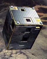
Paris (ESA) Oct 25, 2004 ESA's first microsat has completed three years of successful operations. The size of a large television set, Proba was launched to demonstrate new technologies for future European spacecraft, but continues to provide fantastic images of Earth. "It is amazing what we have got out of Proba, our first micro-satellite," says Frederic Teston, ESA's Proba Project Manager. "The mission has successfully demonstrated a number of sophisticated technologies in addition to new approaches in spacecraft construction and operations. "It has 100% lived-up to its full name of 'Project for On-Board Autonomy' - for every day of the last three years the spacecraft performed onboard such functions as steering, navigation, target fly-by estimation and image capture. These are all functions that have to be handled from the ground for larger spacecraft. "We just provide the latitude, longitude and altitude of a target site, and Proba will handle the rest. The onboard computer steers the spacecraft to the correct position, tilts it correctly, shoots and delivers the image." The thinking underpinning Proba is that tightly focused missions can be delivered in a short time frame useful to scientists - if the time taken from the original concept to launch and operation can be greatly reduced. So to simplify its construction - as well as reducing costs - Proba was constructed as much as possible with existing off-the-shelf components, rather than customised space-hardened parts typical for satellites. The good news is that these systems have continued to work well throughout Proba's 1096 days in space. In polar orbit 600 kilometres above the Earth, each month Proba acquires around 300 images of about 60 separate sites. To date the spacecraft has provided more than 10 000 images from its two onboard imaging instruments: the Compact High Resolution Imaging Spectrometer (CHRIS) and the black and white High Resolution Camera (HRC).
Seeing the world in hyperspectral vision That combined ability to retrieve hyperspectral and multi-angular data makes it especially useful for the study of land vegetation cover. It is also useful for studying the atmosphere and bodies of water. Around 60 scientific teams worldwide are now making use of CHRIS results. Its high spatial resolution make its data especially useful as a 'bridge' between results from satellite instruments such as Envisat's Medium Resolution Imaging Spectrometer (MERIS) and aerial photography. CHRIS data are being used to increase the accuracy of wetland monitoring as part of ESA's Globwetland project, supplying information on the environmental condition of these high-biodiversity areas in support of the international Ramsar Convention on Wetlands. Images from the instrument are being utilised within projects for the ESA-China Dragon Programme, including the study of flood-prone areas. CHRIS images are being used to generate reference maps to be compared with crisis data in order to differentiate flooded areas from permanent water bodies. Chinese researchers have indicated their interest in other applications for the hyperspectral imager, such as mineral prospecting. CHRIS acquisitions are being coordinated with the German fire-detecting satellite BIRD (Bi-Spectral Infrared Detection). CHRIS has been reacquiring sites of forest fires previously detected by BIRD to identify the extent of the burnt area and identify any vegetation regrowth, in order to study the long-term effects of the blazes. In a related field, CHRIS images have also been acquired on behalf of the international Charter for Space and Major Disasters, an international agreement to makex space resources available to civil protection agencies responding to natural disasters. And in the year to come, new planned scientific applications of CHRIS data include precision farming research in Germany, studying spectral reflectance of crop residues and soils in France, biodiversity monitoring in Africa, coastal area mapping in the south of Chile and archaeological projects in Spain.
Proba's additional payload Another instrument in its payload is the Debris In-orbit Evaluator (DEBIE) which monitors tiny micrometeoroids or space debris between a centimeter to under a millimetre in diameter.
About Proba Proba's unique capabilities also makes it a useful resource in the development of ESA's proposed SPECTRA (Surface Processes and Ecosystem Changes Through Response Analysis) mission, an Earth Explorer spacecraft intended to study terrestrial vegetation across the world's major biological communities or 'biomes'. If selected for development, SPECTRA would launch around 2012. Proba was intended as a one-year technology demonstration mission, but has since had its lifetime extended to serve as an Earth Observation mission. A follow-on technology demonstrator called Proba-2 is due to be deployed by ESA by the end of 2007. As with its predecessor the new mission will prove new technologies and new products in orbit. The system built around these developments is intended to support a Sun observation and plasma measurement mission. A new type of solar spectrometer combined with high spacecraft performance will provide for the first time, high-data rate imaging of the Sun. Related Links Proba SpaceDaily Search SpaceDaily Subscribe To SpaceDaily Express
 Toulouse, France (SPX) Oct 25, 2004
Following the Demeter satellite in June, Parasol, the second-up in the Myriade microsatellite series, is preparing for launch. Parasol satellite (Polarization and Anisotropy of Reflectances for Atmospheric Sciences coupled with Observations from a Lidar) will study the impact of aerosols and how they interact with clouds to give scientists a better understanding of Earth's climate system. |
|
| The content herein, unless otherwise known to be public domain, are Copyright 1995-2006 - SpaceDaily.AFP and UPI Wire Stories are copyright Agence France-Presse and United Press International. ESA PortalReports are copyright European Space Agency. All NASA sourced material is public domain. Additionalcopyrights may apply in whole or part to other bona fide parties. Advertising does not imply endorsement,agreement or approval of any opinions, statements or information provided by SpaceDaily on any Web page published or hosted by SpaceDaily. Privacy Statement |