| . |  |
. |
| . | |
. |
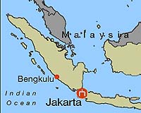
Jakarta (AFP) Nov 19, 2007 International scientists are concerned about the growing threat of an earthquake or a tsunami in the Indonesian city of Padang, which has 800,000 inhabitants. This port on the west coast of Sumatra, about 400 kilometres (250 miles) from Singapore and twice that from Jakarta, is located between two lines of high seismic activity: the Great Sumatran fault, on the mainland to the east, and the Sumatra trench, a subduction zone under the ocean, to the west. It is the subduction zone that is of greatest concern: friction undersea between the descending Indo-Australian plate and the Eurasian tectonic plate, which move together at a rate of five to six centimetres (two to three inches) per year, is eventually likely to cause death and destruction in Padang, the scientists warn. Seismic risk is present throughout Sumatra, an island stretching some 1,700 kilometres in length, but it is particularly true in this city, said Christophe Vigny, from France's government-funded National Centre for Scientific Research (CNRS). Seismologists divide the subduction zone along Sumatra into different segments, which accumulate energy that can be suddenly unleashed by an earthquake. A series of earthquakes in recent years -- including one of magnitude 8.2 that struck the town of Bengkulu in September, and one off Aceh that triggered the Indian Ocean tsunami of December 2004 -- show that all the different segments have released their energy, except that of Padang. "The earthquake in 2004 broke 1,200 kilometres of fault starting from three degrees (latitude) north. The earthquake of 2005 has broken 400 to 500 kilometres opposite Nias (roughly minus one degree to plus three degrees)," Vigny said, referring to the island most badly affected by the quake. "In 2000, a smaller quake broke about 100 kilometres between minus six degrees and minus five degrees. The final sequence of earthquakes broke, prima facie, a 300-kilometre rift between minus five degrees (Bengkulu) and minus two degrees," he added. "Conclusion: the entire subduction broke from 6 degrees south to the Andaman Sea, at 12 to 14 degrees north except a small piece of 100 to 200 kilometres long just in front of Padang, between minus two degrees and minus one degrees," said the researcher, who has just returned from Sumatra. Danny Hilman Natawidjaja, geologist at the Indonesian Institute of Sciences, agreed. "We now know that the Mentawai segment (facing Padang) has accumulated a lot of strained energy. It will be the next one to rupture," he told AFP. Natawidjaja estimated that the quake's magnitude could reach 8.5 to 8.9. "The shaking will be very strong" in Padang, he said, with many buildings likely to collapse. The number of casualties "will depend on how many people can escape" but, according to a worst-case scenario, a tsunami wave would be 5.5 metres high and go two kilometres deep into Padang, devastating "half of the city". Kerry Sieh, a geologist specialising in Sumatra at the California Institute of Technology, said a disaster hitting the Padang region was "highly likely". "The hardest job is changing the infrastructure so that building collapses due to shaking are minimised and deaths and property losses due to tsunami inundation are minimised," he said. The danger was also confirmed by Fauzi, a seismologist from Indonesia's meteorology agency, though he stressed that "we do not have the capability to predict an earthquake". Since the tsunami of 26 December 2004, which killed some 168,000 in Sumatra, the international community has poured around 60 million dollars into building a tsunami warning system for the benefit of Indonesia and the rest of the Indian Ocean, according to Michael Rottmann, coordinator of the tsunami warning system for UNESCO. The goal is to eventually install a comprehensive system that would be effective within 15 minutes -- about the time it would take for a tsunami to strike -- involving seismographs, buoys that can detect changes in sea levels, warnings broadcast by media and SMS, and sirens on the coast. But the Indonesian bureaucracy and the complexity of a system involving 16 public institutions have delayed implementation. Padang has only six sirens on its coastline. So far efforts have focused on educating residents, according to Tabrani, an official from Bakornas, the national disaster management agency. Various other measures such as building artificial hills or towers where people could seek refuge were also under consideration, he said. UNESCO's Rottmann warned of the potential danger of false tsunami alarms in Padang. "Padang is a very difficult place because of its density. How can you evacuate so many people? I don't think it is possible to ask people to run away in the traffic jams," he said. Community Email This Article Comment On This Article Related Links Bringing Order To A World Of Disasters When the Earth Quakes A world of storm and tempest
 Barguna, Bangladesh (AFP) Nov 18, 2007
Bangladesh said Sunday the death toll from a massive cyclone was over the 2,200 mark, with the grim tally rising fast and millions left homeless, hungry and without medical help. |
|
| The content herein, unless otherwise known to be public domain, are Copyright 1995-2007 - SpaceDaily.AFP and UPI Wire Stories are copyright Agence France-Presse and United Press International. ESA Portal Reports are copyright European Space Agency. All NASA sourced material is public domain. Additional copyrights may apply in whole or part to other bona fide parties. Advertising does not imply endorsement,agreement or approval of any opinions, statements or information provided by SpaceDaily on any Web page published or hosted by SpaceDaily. Privacy Statement |