| . |  |
. |
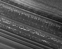
Pasadena CA (SPX) Oct 02, 2006 Mars is ready for its close-up. The highest-resolution camera ever to orbit Mars is returning low-altitude images to Earth from NASA's Mars Reconnaissance Orbiter. Rocks and surface features as small as armchairs are revealed in the first image from NASA's Mars Reconnaissance Orbiter since the spacecraft maneuvered into its final, low-altitude orbital path. The imaging of the red planet at this resolution heralds a new era in Mars exploration. The image of a small fraction of Mars' biggest canyon reached Earth on Friday, the beginning of a week of tests for the High Resolution Imaging Science Experiment and other instruments on NASA's Mars Reconnaissance Orbiter. "We are elated at the sharpness of the image, revealing such fine detail in the landscape," said Dr. Alfred McEwen of the University of Arizona, Tucson, who is the principal investigator for this camera. The target area includes the deepest part of Ius Chasma, one portion of the vast Valles Marineris canyon. Valles Marineris is the largest known canyon in the solar system, as long as the distance from California to New York. The camera returned test images after Mars Reconnaissance Orbiter went into orbit around Mars on March 10, 2006, but those were from altitudes more than eight times as high as the orbiter is flying now. Since March, the spacecraft has shrunk its orbit by dipping more than 400 times into the top of the Martian atmosphere to shave velocity. It is now flying in its final, nearly circular orbit at altitudes of 250 to 316 kilometers (155 to 196 miles). The orbit will remain this shape and size for the mission's two-year primary science phase, which begins in November. During its primary science phase, Mars Reconnaissance Orbiter will return more data about the red planet than all previous missions combined, pouring data to Earth at about 10 times the rate of any earlier Mars spacecraft. Scientists will analyze the information to gain a better understanding of the distribution and history of Mars' water -- whether ice, vapor or liquid -- and of the processes that formed and modified the planet's surface. In addition to the high-resolution camera, the orbiter's science payload includes a mineral-identifying spectrometer, a ground-penetrating radar, a context camera for imaging wide swaths of the surface, a wide-angle color imager for monitoring the entire planet daily, and an instrument for mapping and monitoring water vapor and other constituents in the atmosphere. For most of October, Mars will be passing nearly behind the sun from Earth's perspective. Communication will be intermittent. Activities will be minimal for Mars Reconnaissance Orbiter and other spacecraft at Mars during this time, and they will resume in early November. Related Links Mars Reconnaissance Orbiter HiRoc at Arizona CRISM at APL Mars News and Information at MarsDaily.com
 College Park MD (SPX) Oct 02, 2006
The team of the University of Maryland, College Park, the University of Maryland, Baltimore County, and the Universities Space Research Association has been selected by the NASA Goddard Space Flight Center to establish and operate the Center for Research and Exploration in Space Science and Technology. CRESST will bring together NASA Goddard researchers and scientists from the Maryland campuses and USRA to build upon the many capabilities and strengths in space science of the participating organizations. |
|
| The content herein, unless otherwise known to be public domain, are Copyright 1995-2006 - SpaceDaily.AFP and UPI Wire Stories are copyright Agence France-Presse and United Press International. ESA PortalReports are copyright European Space Agency. All NASA sourced material is public domain. Additionalcopyrights may apply in whole or part to other bona fide parties. Advertising does not imply endorsement,agreement or approval of any opinions, statements or information provided by SpaceDaily on any Web page published or hosted by SpaceDaily. Privacy Statement |