| . |  |
. |
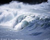
Pasadena CA (JPL) Jun 19, 2006 Sea level isn't, well, level. Nor is the rate by which sea level has been rising over the past few decades, but the trend is clearly up. Global sea level has risen an average of three millimeters (.1 inch) per year since 1993. Rising seas have the potential to affect billions of people around the globe, not just those living near coastlines. With the ocean soaking up more heat from a warming planet and glaciers melting at a record-breaking pace, is there any way to know where and when sea level may level off? Measuring changing sea level is just the beginning. "One single number for sea level rise isn't all you need to know," says JPL's Dr. Michael Watkins. "You want to know what's happening in different locations. You also want to know if it is accelerating. You want to put the current decade under a microscope and see exactly what's going on." Watkins is the project scientist for the Gravity Recovery and Climate Experiment (Grace), one of several NASA missions and projects that are helping to dissect sea level rise and understand the individual components that make up the whole complicated system. Scientists now have the tools to begin to understand the mechanisms that drive global sea level and make better predictions for the future. "Global sea level can rise for one of two reasons," says JPL oceanographer Dr. Josh Willis. "One is when water gets hotter, it expands. The other is when water is added to the ocean, which changes its mass. That happens, for example, when glaciers melt." Different Tools for Each Part of the Problem No single ocean observing system can pick out exactly the source of rising seas, but by combining measurements made by different instruments, scientists can get very close. "For studying sea level, there are basically three global observing systems," says Willis. One is made up of satellite altimeters, like the recently retired Topex/Poseidon and its follow-on Jason, which make precise measurements of ocean surface height. Altimeters provided the first detailed picture of global sea level and now track its change. Altimeters measure total ocean height. The total height of the ocean is the result of changes in mass, thermal expansion and, in some cases, salinity. Different observation systems are needed to isolate the contribution that each of these factors makes to the whole, explains Willis. That's where the Grace mission comes in. It measures the change in mass of water on Earth and its location. "Grace contributes to sea level measurements in two ways. It measures the mass of ice as well as the mass of the entire ocean," says Watkins. If the water is frozen, as on Antarctica, and then melts, Grace can measure that change and how it evolves over time, he explains. For example, researchers using Grace data found that the mass of ice in Antarctica had decreased significantly from 2002 to 2005, enough to raise global sea level by 1.5 millimeters (0.05 inches) during that period. The third global observing system consists of thousands of ocean floats, in situ profilers, like those of the international Argo array. They measure temperature from the top of the ocean down to 2,000 meters (about 6,600 feet) depth. "Ideally if you were to add up the thermal component that the in situ profilers see with the mass that Grace measures, you should get the total sea level that Jason observes," says Willis. "That should work for the global average, but the patterns of sea level change are more complicated." For example, fresh water isn't as dense as salty water. As a result, fresh water with the same amount of mass as salty water will take up more volume. "So if you're worried about sea level rise in a particular place, say a small island in the Pacific," says Willis, "you need to know how salty the nearby water is, too, and whether that may be changing." The Argo floats, he adds, also measure salinity, and now that the system is global, it will help us understand this component of sea level better in the future. In 2009, NASA will launch the Aquarius satellite to provide direct measurements of sea surface salinity from space, providing more information on this missing piece of the climate puzzle.
How High and How Fast? Researchers say that about half of the rise in global sea level since 1993 is due to thermal expansion of the ocean and about half to melting ice. As Earth warms, these proportions are likely to change with dramatic results. "More heat is coming into Earth's atmosphere than is going out," says Dr. Lee-Lueng Fu, project scientist for the Jason mission. "Over the past 40 years, the ocean has absorbed 84 percent of this excess heat--enough heat to warm the entire atmosphere by 27 degrees Celsius (49 degrees Fahrenheit)." The ocean has been able to absorb this heat by mixing warm surface water with much colder water from its depths, he explains. "The question is how long can it continue to do this." Add more heat to the oceans, already Earth's largest storehouse of solar radiation, not only does global sea level rise due to thermal expansion but circulation patterns could change and affect the ocean's ability to store more heat in the future. Excess heat that doesn't go into the ocean has to go somewhere. If it's melting ice, the effect on sea level will be immense. Melting, not warming, has the biggest potential to raise sea level. "If you warm up the ocean, it will rise perhaps half a meter (1.6 feet)," says JPL researcher Dr. Eric Rignot. "If you melt land ice, you could raise sea level by 70 meters (230 feet). The real concern over the long term is the ice sheets in Greenland and Antarctica. With thermal expansion, the coastlines erode; with the ice sheets melting completely, you are talking about cities and states under water." Rignot and his colleagues have been using radar measurements from several different satellites to find out just how fast ice sheets are discharging into the ocean. He and his colleagues recently found that glaciers in Greenland are accelerating in response to climate warming. The loss of ice doubled between 1996 and 2005. "There are a lot of changes taking place in Greenland," says Rignot. "and we expect to see acceleration in ice loss continuing north in the next ten years." By tracking the flow of glaciers around the globe, researchers will have a much better idea about the rate of change. Melting ice on Greenland raised global sea level by three and half meters (about 11 feet) in the last interglacial," Rignot says, "this is where we are heading and it looks like we could get there much sooner than we thought." Related Links -
 Richland WA (SPX) Jun 19, 2006
Cheatgrass, a fast-growing, fire-fueling weed, has met its match. The Idaho Bureau of Land Management and several weed control groups are fighting back with new software that uses NASA satellite imagery and complex computer programs to show the location and growth of this noxious plant that has invaded the arid West from desert lowlands to high mountains. |
|
| The content herein, unless otherwise known to be public domain, are Copyright 1995-2006 - SpaceDaily.AFP and UPI Wire Stories are copyright Agence France-Presse and United Press International. ESA PortalReports are copyright European Space Agency. All NASA sourced material is public domain. Additionalcopyrights may apply in whole or part to other bona fide parties. Advertising does not imply endorsement,agreement or approval of any opinions, statements or information provided by SpaceDaily on any Web page published or hosted by SpaceDaily. Privacy Statement |