| . |  |
. |
| . | |
. |
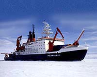
Bremerhaven - Oct 22, 2001 The polar research vessels RV Polarstern and USCGC Healy returned after a ten week successful expedition to the high arctic regions. Together with the new US Coast Guard icebreaker, the USCGC Healy, the Polarstern, run by the Alfred Wegener Institute for Polar and Sea Research (AWI) explored the Gakkel Ridge, the most northerly extension of the Mid-Atlantic submarine mountain chain in the course of the combined AMORE-expedition (Arctic Mid-Ocean Ridge Expedition). During this cruise both ships managed to reach the North Pole -- exactly 10 years after RV Polarstern and the Swedish ice breaker Oden had steamed to this magic location. AMORE 2001 was a historic milestone in the exploration of the Northern Polar Sea. The expedition combined two highly efficient modern research ice breakers in all operations, a goal that required the highest nautical efforts. For the first time an important part of the geologically interesting and volcanically and tectonically active Gakkel Ridge has been mapped and sampled with the highest possible precision. No one is better qualified to understand the importance of this expedition than J�rn Thiede, director of the AWI, or to appraise the overall outcome of the ARK XVII/2 expedition, as he was the chief-scientist of this spectacular entertainment and lead 60 scientists of various universities and research institutes into the central Arctic Ocean from the 31st of July till the 7th of October 2001. The twenty year old RV Polarstern, which is still one of the most up-to-date and modern ships of its class. She conducted the expedition with the new ice breaker Healy from Seattle. The Healy primarily serves the US Coast Guard, but most of the time it is employed as a research and transport platform, dedicated to civil polar research. The main target of the two closely-operating ships was the Gakkel Ridge.
Mysterious Plate Boundary This mountain chain is found all along the Mid Atlantic Ocean and the adjacent European Northern Sea and ends finally once it reaches the Siberian Laptev Sea. Through the central fissures of the Mid Ocean Ridges magma forms in the earth's mantle and extrudes on to the sea floor, thus forming new oceanic crust. In the course of this Seafloor Spreading not only is new oceanic crust formed but a displacement of the continental masses also takes place. The Rift systems represent the borders of about a dozen of plates, forming the entire earth's crust. These systems carry the continents and the oceans. Thus, the earth's surface can be compared to the surface of a soccer ball with its seams. Along these seams, which are the borders of the diverging plates of the earth's crust the volcanic ridge systems developed and the basic processes of plate tectonics can be studied. The spreading rates of the diverging plate boundaries can be up to 10 to 20 cm per year, c.f., along the East Pacific Ridge system, but much lower rates are known. The Gakkel Ridge, situated in the central part of the eastern north Polar Sea forms the most northerly boundary between Eurasia and North America. At the same time it represents the ridge segment with the lowest known spreading rates. Spreading takes place at a speed of less than 1 cm per year on the average. Geologists discovered that the northern Atlantic ocean and the eastern Arctic ocean formed in early Tertiary period, i.e., during the last 55 Ma or so. "These two oceans and the Northern boundaries of Europe are of young geological age," explains J�rn Thiede, a specialist for paleo-oceanography. "Therefore we assumed a variety of geological phenomena, which have been explained in the course of our recent expedition." For the first time precise maps of the Gakkel Ridge haven been achieved During the AMORE cruise the western part of the Gakkel Ridge has been mapped, measured and sampled precisely by both the Healy and the Polarstern in a combined effort. "We now have a clear picture of this submarine mountain chain, which has for a long time been nameless and mysterious: below a deceptive, drifting Arctic sea-ice cover, a mountain chain is hidden which in places rises thousands of meters over the neighbouring deep sea basins. The crest is divided by an elongated, narrow and not continuous rift valley, where dramatic volcanic processes recently occurred." In 1999 this region attracted the attention of earth scientists. During the SCICEX-program (Scientific Ice Experiment), US nuclear submarines were used to do research under the Arctic sea-ice and measured some properties of the Gakkel Ridge with Side-Scan Sonar instrumentation. They made an astonishing discovery: in the center of the Gakkel Ridge, at 85 deg East, they found evidence of submarine volcanic eruptions. Prior to this, scientists of the AWI had already detected high seismic activity at the same location. RV Polarstern recently placed seismic recording stations on the ice plates over the location at 85 deg E and recorded at least some recent seismic events: "Overall we found only signs of fairly seismic activity, but in general we can state that Gakkel Ridge is seimically more active than previously assumed," comments Dr. Wilfried Jokat (AWI) on these results. "More measurements should help to get an idea of how thick the crust along the Gakkel Ridge and within the bordering deep sea basins is. Gakkel Ridge is the ideal place to test present models of global sea floor spreading on ultra slow ridges," says Jokat.
Cooperation with the Healy Jokat, a world famous and distinguished geophysist: "The crustal thickness values do not reflect any model predictions. The crustal thickness varies between 2 and 6 km. Apparently in a few places mantle rocks are displayed within the rift valley and are altered exclusively by penetrating seawater and resulting hydrothermal convection cells." Also spectacular are the seismic profiles through the bordering deep sea basins. They allow, for the first time, a clear estimation of the variations in thickness of the oceanic basement, which is covered by kilometre-thick sediments, forming the ocean floor in these basins. Following a precise bathymetric measurement the Polarstern and the Healy are now able to reveal the existence of complex volcanic cones in many areas of the Gakkel Ridge. "These measurements also clearly demonstrate," says Jokat, "that the central Gakkel Ridge rift valley is deeper than any other mid ocean ridge valley known on earth. This is clearly controlled by its slow spreading rate. Furthermore, it appears that an unexpectedly high number of volcanoes can be seen in the rift valley. These phenomena are revealed by the high quality of our bathymetric maps, which allow a surprising view of the structure of this ridge and thus clearly constitute one of the most spectacular results of our journey."
Touching the sea floor Some of the scientists involved had predicted that the Gakkel Ridge constitutes the result of a series of tectonic movements rather than volcanic processes. Consequently, they had expected to sample mainly peridotites -- rocks from the earth mantle which can be placed on the sea floor on tectonic processes. "Instead of peridotites we recovered mainly basalts, which struck me absolutely by surprise," says Dr. Jonathan Snow of the MPI Mainz of the results. Similarly, the sediment cores recovered from the seafloor close to the large Siberian shelf areas also to allow new insights. In short, the goal of AMORE 2001 is to write a new chapter in the history of the sea ice coverage of the Arctic ocean. As an outcome of the improved and close cooperation of Russian and West European scientists, it has become evident that the large-scale glaciation of Northern Asia during the last ice age did not follow the same time pattern as Northern Europe. "Recent geological mapping allows us to state now that the glacial maximum in Northern Siberia happened some ten thousand years before the glacial maximum observed in Scandinavia and the Alps, which took place before 20,000 years," explains Dr. Robert Spielhagen from GEOMAR Research Cetner in Kiel. "We intend with our investigations on the sediment cores to date the arrival of the glacial maximum on the Arctic Ocean and show that the resulting melting waters influenced oceanic circulation and the world's climate." A second goal of this work is to define the role of humidity transport along open water pits within the sea ice and determine whether large ice shelfs comparable to those seen in the Antarctic Sea existed also in the Arctic.
No Hole In The Ice of the North Pole AWI specialists explained that such open water pits, called polynia, exist every summer in great numbers within the sea ice cover but the startling hot summer-hole discussions overwhelmed all scientifically relevant explanations. Therefore one of the goals of this expedition was the observation of variations in sea ice thickness and distribution in the Arctic Ocean, and to compare this to data from 1991 and 1998. "The ice is back. We saw normal conditions this summer on the North Pole, kilometer wide large ice flows with numerous small and larger polynias in between. The ice was already covered by fresh snow and on the water new ice was forming relatively early compared to previous seasons. The sea ice thickness however, was less than our previous measurements, 2 meters compared to 2.5 meters in 1991," according to Dr. Christian Haas from the AWI, head of the ice researcher group.
Manifold activities on the ice Another aspect of the work of the ice group was the determination of physical and biological parameters of ice and melt ponds. Ice cores were drilled and examined, along with satellite and aerial images, in order to determine the degree of sun light reflection (Albedo) of the various ice surface types evaluated. One very exciting aspect of the ice group's work was the observation of small non-vertebrate animals living within the ice. These animals manage to avoid freezing their body fluids, and their food supply was of special interest.
Icy Social Events It was September 6th when both ships reached the target after a difficult journey through heavy ice and under bad weather conditions. "We had to steam around old ice flows of 5 to 10 kilometers diameter," explained the captain of RV Polarstern, J�rgen Keil. "As a result we had to fight severe time delay and longer cruise distances of up to 3 hours. New ice and small disrupted ice flows needed the full power of Polarstern's engines. In addition the highest concentration of nautical officers on watch was necessary in order to find the right passages through the ice. The excellent cooperation with Healy was a great advantage." The date of arrival to the North Pole was the anniversary of the day when the Polarstern together with the Swedish ice breaker Oden reached this magic location ten years ago, as the first conventionally powered civil research platforms. The meeting of the three ships Polarstern-Oden-Healy a few days before this event was in some ways a first test of the North Pole adventure.
A peaceful international Contest The members of the scientific teams represented not only the most diverse research and university institutes, but together with the ship's crew also an international group of people from 17 nations: Australia, Brasilia, China, Germany, Estonia, Finland, Great Britain, Italy, Canada, Netherlands, Norway, Austria, Russia, Sweden, Suisse, Spain and the United States of America. The cruise of this multidisciplinary group of people into the remote and untouched regions of our earth clearly demonstrates that Arctic research has become an international business. The secrets of the Northern Polar Sea, which not long ago was known as a contested area of military and political interests, have been brought into the light in the course of a peaceful international expedition. This is a fact untouched even by horrible terrorist attacks like those that happened on September 11th in New York. Related Links Alfred Wegener Institute for Polar and Marine Research SpaceDaily Search SpaceDaily Subscribe To SpaceDaily Express
 Minneapolis - Oct 22, 2001
It won't happen overnight, but eventually, the floor of the Atlantic Ocean will plunge beneath the North American continent, forming a deep trench about 2,000 miles long and possibly generating volcanoes, according to research at the University of Minnesota and the Swiss Federal Institute of Technology in Zurich. |
|
| The content herein, unless otherwise known to be public domain, are Copyright 1995-2006 - SpaceDaily.AFP and UPI Wire Stories are copyright Agence France-Presse and United Press International. ESA PortalReports are copyright European Space Agency. All NASA sourced material is public domain. Additionalcopyrights may apply in whole or part to other bona fide parties. Advertising does not imply endorsement,agreement or approval of any opinions, statements or information provided by SpaceDaily on any Web page published or hosted by SpaceDaily. Privacy Statement |