| . |  |
. |
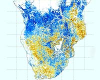
Paris, France (ESA) Jul 17, 2007 The first soil moisture maps with a spatial resolution of one km are available online for the entire southern African subcontinent. As soil moisture plays an important role in the global water cycle, these maps, based on data from ESA's Envisat satellite, will lead to better weather and extreme-event forecasting, such as floods and droughts. "Predicting when and where floods are likely to happen is becoming more and more important," Geoff Pegram of the University of KwaZulu-Natal, South Africa, said. "Although we cannot prevent floods, we can anticipate them and hopefully get people out of the way. This brings hydrology into the 21st century and makes life better for people." Soil moisture is the water stored in the soil within reach of plants. When there is too little soil moisture, rain-fed crops and natural vegetation wilt. When there is too much soil moisture, the risk of flooding, flash floods and erosion increase. Despite its importance for agricultural planning and weather forecasting, there has been a lack of soil moisture information in Africa because of the high costs of in-situ measurement networks. In addition, unlike satellite observations, point-based measurements are often not sufficient to provide an overall picture over large areas that may be effectively used in models. The ESA-backed SHARE (Soil Moisture for Hydrometeorological Applications in the Southern African Development Community Region) project, funded through the ESA's Data User Element, is the first to demonstrate that spaceborne Synthetic Aperture Radar (SAR) instruments can deliver soil moisture data of high spatial (one km) and temporal (less than one week) resolution. The SHARE project team combines expertise in soil moisture remote sensing from Vienna University of Technology with specialists in hydro-meteorological applications from University of KwaZulu-Natal in Durban, South Africa. "I think it is really a breakthrough. Envisat is the first satellite to provide us with the good temporal coverage that we needed for the algorithm and the methods to be successful," Wolfgang Wagner of the Vienna University of Technology said. "Chinese scientists have already used our data to initialise weather forecasts and demonstrated they could better predict the location and intensity of a precipitation event, which resulted in a flood. Soil moisture is such an important variable that it influences vegetation, soil, run-off and weather, affecting the lives of us all." SHARE was one of the projects initiated under ESA's TIGER initiative, launched in 2002 to assist African countries to overcome water-related problems and to bridge Africa's water information gap using satellite data. To date, more than 200 African water basin authorities, universities and other organisations have become involved in TIGER projects across the continent. The TIGER initiative is implemented in three stages - research, pre-operational and operational. The research stage encourages water authorities in Africa to undertake research initiatives and supports them with Earth observation (EO) data, training and tools. The pre-operational stage aims to demonstrate tailored EO-based services and systems for collecting water-related information. The operational stage is aimed at transferring the leadership of the projects to African water authorities. SHARE concluded its pre-operational stage last month and will now seek funding and support from African organisations. Community Email This Article Comment On This Article Related Links Envisat overview TIGER University of KwaZulu-Natal Vienna University of Technology Weather News at TerraDaily.com
 Montreal, Canada (AFP) July 13, 2007
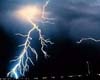
A 37-year-old Canadian man who was struck by lightning while jogging and wearing his iPod suffered more severe injuries due to the metal electronic device, according to a report published Thursday. In 2005, the man was listening to his iPod and jogging in Burnaby, in British Columbia when lightning hit a nearby tree, then struck him, hurling him more than two meters (yards) into the air. |
|
| The content herein, unless otherwise known to be public domain, are Copyright 1995-2007 - SpaceDaily.AFP and UPI Wire Stories are copyright Agence France-Presse and United Press International. ESA Portal Reports are copyright European Space Agency. All NASA sourced material is public domain. Additional copyrights may apply in whole or part to other bona fide parties. Advertising does not imply endorsement,agreement or approval of any opinions, statements or information provided by SpaceDaily on any Web page published or hosted by SpaceDaily. Privacy Statement |