| . |  |
. |
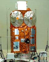
Paris, France (SPX) Feb 27, 2006 The European Space Agency (ESA) announced Friday it would replace an important climate research satellite that was lost in a launch by a Russian rocket last October. The 140-million-euro (170-million-dollar) CryoSat satellite was irretrievably lost shortly after lift-off on a converted Soviet-era ballistic missile from a base in northwest Russia on October 8. At a two-day meeting in Paris, ESA's Earth Observation Board was given the green light to build and launch a replacement, which will be called CryoSat 2, the agency said in a statement. The satellite is expected to be launched in March 2009. "This decision is very important, as the scientific community in Europe and elsewhere is eagerly awaiting resumption of the CryoSat mission," said Volker Liebig, ESA's director of Earth observation programs. The first CryoSat spacecraft had to be destroyed last Oct. 8, when its launch vehicle malfunctioned. CryoSat-2 will be designed to carry out a three-year mission to monitor precisely any changes in the elevation and thickness of polar ice sheets and floating sea ice. The satellite will need to orbit at an unusually high inclination, reaching latitudes of 88 degrees North and South, ESA said in a statement. CryoSat's main instrument, the SAR/Interferometric Radar Altimeter, or SIRAL, is based on existing technology, but engineers will enhance the basic design to overcome some of the difficulties associated with tracking ice surfaces precisely. For example, one of the spacecraft's two antennas will send out radar signals, but both will detect the signal echoes from Earth's surface. By using highly accurate positioning data for the spacecraft - achieved with an onboard ranging instrument called a Doppler Orbitography and Radiopositioning Integrated by Satellite, or DORIS, receiver supplemented by a laser retro-reflector system - the signal return time will reveal the surface altitude. CryoSat-2 will maintain its correct antenna orientation using a trio of star trackers. ESA also said SIRAL's new design will provide detailed views of irregular sloping edges of land ice and non-homogenous ocean ice.
This story is partly based on a story via Agence France-Presse Related Links Cyrosat
 Paris, France (SPX) Feb 20, 2006
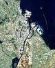
This Proba image shows the historic port of Copenhagen, the capital of Denmark for the last 600 years. Appearing off the coast like a string of pearls is a 21st Century addition to the city: one of the largest offshore wind farms in the world. |
|
| The content herein, unless otherwise known to be public domain, are Copyright 1995-2006 - SpaceDaily.AFP and UPI Wire Stories are copyright Agence France-Presse and United Press International. ESA PortalReports are copyright European Space Agency. All NASA sourced material is public domain. Additionalcopyrights may apply in whole or part to other bona fide parties. Advertising does not imply endorsement,agreement or approval of any opinions, statements or information provided by SpaceDaily on any Web page published or hosted by SpaceDaily. Privacy Statement |