| . |  |
. |
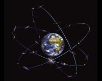
Darmstadt, Germany (SPX) May 17, 2006 Based on new research in navigation and measurement, scientists think Earth-watching satellites could monitor sea-level and atmospheric changes with enough precision they someday could help predict tsunamis and earthquakes. That is just one prospect discussed by more than 140 geoscience and navigation experts from around the world, who met last week at a Global Navigation Satellite Systems workshop at ESA's European Science Operations Center to present their latest findings on geodesy, geophysics, orbital measurement, navigation and coordinated system design. Many participants work with current satellite-navigation systems, including the 29 satellites of the U.S. Global Positioning System and the 14 satellites of GLONASS - Russia's Global Navigation Satellite System � though both primarily are military systems. In the near future, Galileo, Europe's next-generation system comprising 30 civilian satellites, will begin operations and join the navigation constellation. Galileo is expected to open a new era in global satellite navigation. One test satellite, GIOVE-A, already is in orbit as the first element of Galileo's in-orbit validation, and further such missions are scheduled for launch in 2008. Another key component of improved satellite data technology will be the Global Geodetic Observing System, which will use highly accurate data and integrate diverse geodetic techniques and models to improve understanding of geodetic, geodynamic and global processes. GGOS also will use highly reliable location data, such as the position of quasars in deep space, to provide a more solid basis for global-change research. "When oceanographers wish to observe sea level variations due to climate change, they must have a well-defined and very accurate global reference frame," said ESA's John Dow, an expert on navigation systems and host of the workshop. "The Earth is a dynamic system and, for example, being able to measure movement due to tsunamis and earthquakes helps us know how these phenomena work and is an essential step in knowing how to predict them." GGOS � a fundamental part of the new Global Earth Observing System of Systems - would bring current and future Earth-watching satellites into one overall system to avoid duplication and boost accuracy and timeliness. GGOS contributes to GEOSS not only by providing an accurate reference frame but also with observations related to the global hydrological cycle, the dynamics of the atmosphere and oceans, and natural hazards and disasters. The system is used by the United Nations and selected national governments. "Geo-information has direct applications in navigation, weather prediction and monitoring and understanding environmental change," Dow said. "These data and services can help improve the lives of millions of people who use information from national governments to plant crops, react to climate change and respond to natural disasters. It is an area of tremendous significance for the future." Related Links Galileo ESA
 London (AFP) May 17, 2006
A British ambulance crew was driven to distraction by an on-board satellite navigation system, whose misdirections made what should have been a routine call-out a two-hour round trip, ambulance service officials said Tuesday. |
|
| The content herein, unless otherwise known to be public domain, are Copyright 1995-2006 - SpaceDaily.AFP and UPI Wire Stories are copyright Agence France-Presse and United Press International. ESA PortalReports are copyright European Space Agency. All NASA sourced material is public domain. Additionalcopyrights may apply in whole or part to other bona fide parties. Advertising does not imply endorsement,agreement or approval of any opinions, statements or information provided by SpaceDaily on any Web page published or hosted by SpaceDaily. Privacy Statement |