| . |  |
. |
Houston TX (SPX) March 1, 2006 Ocean FOCUS began issuing ocean-current forecasts on Feb. 16 - just in time to warn Gulf of Mexico offshore oil and natural gas producers that a new warm eddy had formed in the area. The powerful eddy, which resembled an underwater hurricane, originated from the Loop Current, an intrusion of warm surface water that flows northward from the Caribbean Sea through the Yucatan Strait. Eddies can cause extensive and costly damage to underwater equipment. The latest data show the Loop Current has shifted to the north of its average position, sparking concerns that it could generate more eddies over the next few weeks. The current eddy, dubbed Walker, was detected breaking away from the Loop Current in mid-February. Ocean FOCUS forecasts, based on computer models and ESA satellite measurements, can give prior warnings of eddy formation. Oil companies use the warnings to minimize production losses, optimize deepwater drilling activities and prevent damage to critical equipment. The Loop Current's eddies create induced vibrations, which can cause more component stress than direct force, and they can result in high levels of fatigue and structural failure. The damage caused by eddies can be very costly, in terms of production and exploration downtime and damage to underwater components. Ocean FOCUS data give oil and gas operators information they can use to plan major operations, such as installing new equipment - which can be very sensitive to local conditions and may require prolonged windows of low current speed for successful completion. Ocean FOCUS was developed by Ocean Numerics and is partially supported by ESA's Earth Observation Market Development program. Ocean Numerics is a joint venture between France's Collecte Localisation Satellites, the UK's Fugro GEOS and Norway's Nansen Environmental and Remote Sensing Centre. Related Links Ocean Focus ESA
 Paris, France (SPX) Mar 01, 2006
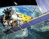
Since its launch in 2002, Envisat, the world's largest and most sophisticated satellite ever built, has been providing scientists and operational users with invaluable data for global monitoring and forecasting � and the future looks even brighter. |
|
| The content herein, unless otherwise known to be public domain, are Copyright 1995-2006 - SpaceDaily.AFP and UPI Wire Stories are copyright Agence France-Presse and United Press International. ESA PortalReports are copyright European Space Agency. All NASA sourced material is public domain. Additionalcopyrights may apply in whole or part to other bona fide parties. Advertising does not imply endorsement,agreement or approval of any opinions, statements or information provided by SpaceDaily on any Web page published or hosted by SpaceDaily. Privacy Statement |