| . |  |
. |
| . | |
. |
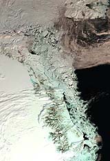
Bergen, Norway (SPX) Nov 07, 2005 Researchers have utilised more than a decade's worth of data from radar altimeters on ESA's ERS satellites to produce the most detailed picture yet of thickness changes in the Greenland Ice Sheet. A Norwegian-led team used the ERS data to measure elevation changes in the Greenland Ice Sheet from 1992 to 2003, finding recent growth in the interior sections estimated at around six centimetres per year during the study period. The research is due to be published by Science Magazine in November, having been published in the online Science Express on 20 October. ERS radar altimeters work by sending 1800 separate radar pulses down to Earth per second then recording how long their echoes take to bounce back 800 kilometres to the satellite platform. The sensor times its pulses' journey down to under a nanosecond to calculate the distance to the planet below to a maximum accuracy of two centimetres. ESA has had at least one working radar altimeter in polar orbit since July 1991, when ERS-1 was launched. ESA's first Earth Observation spacecraft was joined by ERS-2 in April 1995, then the ten-instrument Envisat satellite in March 2002. The result is a scientifically valuable long-term dataset covering Earth's oceans and land as well as ice fields � which can be used to reduce uncertainty about whether land ice sheets are growing or shrinking as concern grows about the effects of global warming. The ice sheet covering Earth's largest island of Greenland has an area of 1 833 900 square kilometres and an average thickness of 2.3 kilometres. It is the second largest concentration of frozen freshwater on Earth and if it were to melt completely global sea level would increase by up to seven metres. The influx of freshwater into the North Atlantic from any increase in melting from the Greenland Ice Sheet could also weaken the Gulf Stream, potentially seriously impacting the climate of northern Europe and the wider world. Efforts to measure changes in the Greenland Ice Sheet using field observations, aircraft and satellites have improved scientific knowledge during the last decade, but there is still no consensus assessment of the ice sheet's overall mass balance. There is however evidence of melting and thinning in the coastal marginal areas in recent years, as well as indications that large Greenland outlet glaciers can surge, possibly in response to climate variations. Much less known are changes occurring in the vast elevated interior area of the ice sheet. Therefore an international team of scientists - from Norway's Nansen Environmental and Remote Sensing Center (NERSC), Mohn-Sverdrup Center for Global Ocean Studies and Operational Oceanography and the Bjerknes Centre for Climate Research, Russia's Nansen International Environmental and Remote Sensing Center and the United States' Environmental Systems Analysis Research Center � were compelled to derive and analyse the longest continuous dataset of satellite altimeter observations of Greenland Ice Sheet elevations. By combining tens of millions of data points from ERS-1 and ERS-2, the team determined spatial patterns of surface elevation variations and changes over an 11-year period.
|