| . |  |
. |
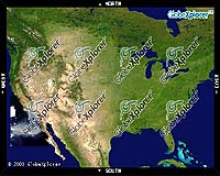
Walnut Creek CA (SPX) Jan 18, 2006 GlobeXplorer announced that it has reached an agreement with the U.S. EPA to make its earth imagery and map data available to all of EPA's staff nationwide. High resolution aerial, satellite, and map data will be available through GlobeXplorer's ImageConnect extensions for GIS software and imbedded in several EPA Web applications. Although GlobeXplorer imagery will be available across the agency, several departments look to especially benefit. EPA GIS departments will be using ImageConnect mapping extensions to bring high-resolution photos directly into their projects. "We love how simple ImageConnect is to install and use, and the currency, resolution and selection of their data is excellent," said Dave Catlin of EPA's Internet Geoservices Team. "The fact that we can share access to the service agencywide between multiple applications makes things a lot easier and cheaper for us." EPA will also be including GlobeXplorer imagery in various departmental map server applications, including several of their EnviroMapper Web viewers. The EPA uses GlobeXplorer's data in several project types, including Superfund site work, wetland analysis, pesticide analysis, endangered species protection and emergency response. ImageConnect is being used extensively by EPA GIS staff for Hurricane Katrina cleanup efforts in Louisiana. "The EPA staff has utilized GlobeXplorer imagery extensively for the past several years, and we're happy to see that they've made the logical step of creating agencywide access," said Paul Smith, GlobeXplorer's COO. "Now they'll have easy access to the best imagery possible for their regional offices across the country from providers like AirPhotoUSA, DigitalGlobe, Sanborn, as well as federal, state, and local government sources." GlobeXplorer's ImageConnect extensions for Autodesk, ESRI, and MapInfo can be freely downloaded from GlobeXplorer's Web site . ImageConnect permits users to access an unmatched archive of high quality geo-referenced imagery inside these applications without conversion. An Open Geospatial Consortium Web Mapping Service (OGC WMS) version is also available upon request. Related LinksGlobeXplorer
 New York NY (SPX) Jan 11, 2006
The importance of remotely sensed data and technologies to support natural disasters has prompted attention and action in Washington. New initiatives and legislation authorizing appropriations to the remote sensing industry will be discussed at Strategic Research Institute's U.S. Commercial Remote Sensing Industry conference, scheduled for February 9-10, 2006 in Washington D.C. |
|
| The content herein, unless otherwise known to be public domain, are Copyright 1995-2006 - SpaceDaily.AFP and UPI Wire Stories are copyright Agence France-Presse and United Press International. ESA PortalReports are copyright European Space Agency. All NASA sourced material is public domain. Additionalcopyrights may apply in whole or part to other bona fide parties. Advertising does not imply endorsement,agreement or approval of any opinions, statements or information provided by SpaceDaily on any Web page published or hosted by SpaceDaily. Privacy Statement |