| . |  |
. |
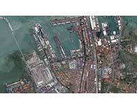
Longmont CO (SPX) May 29, 2006 DigitalGlobe announced Monday its collection of high- resolution satellite imagery depicting newsworthy events and locations from around the world is now available to editorial customers via Getty Images. By providing access to its imagery through gettyimages.com, DigitalGlobe is improving its services to the media with timely and affordably priced imagery, easy and immediate access, and a centralized online location, the company said in a statement. "With gettyimages.com serving an average of 3.5 million unique visitors each month, more and more media around the world will be aware of the availability of DigitalGlobe imagery,� said Jill Smith, president and chief executive officer of DigitalGlobe. �That can only be a positive force as we educate audiences about the value of satellite imagery for illustrating, mapping and preparing for important events." Members of the media use DigitalGlobe imagery to illustrate news-breaking events such as natural and man-made disasters, sporting venues and cultural events, as well as areas of global interest. DigitalGlobe imagery has, in some cases, been the first source of visual information about an event. For instance, imagery collected just moments after the Southeast Asian tsunami struck land on Dec. 26, 2004, offered the first glimpses of the devastation for many news consumers. DigitalGlobe's archive of satellite imagery is updated on a daily basis for all editorial customers. Additional distribution of this content also will be offered via a DigitalGlobe-branded Web site, built and maintained by Getty Images, the company said. Related Links Digital Globe Getty Images
 Denver CO (SPX) May 29, 2006
Intermap Technologies Corp. announced Monday its Intermap Federal Services subsidiary has been awarded a $5.6 million contract to collect and deliver geographic three-dimensional elevation and imagery data via Intermap's radar mapping technology. The name of the client was not disclosed. |
|
| The content herein, unless otherwise known to be public domain, are Copyright 1995-2006 - SpaceDaily.AFP and UPI Wire Stories are copyright Agence France-Presse and United Press International. ESA PortalReports are copyright European Space Agency. All NASA sourced material is public domain. Additionalcopyrights may apply in whole or part to other bona fide parties. Advertising does not imply endorsement,agreement or approval of any opinions, statements or information provided by SpaceDaily on any Web page published or hosted by SpaceDaily. Privacy Statement |