| . |  |
. |
| . | |
. |
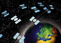
Paris (ESA) May 13, 2003 Communication satellites will eventually be able to tell us where they are using new on board GNSS (Global Navigation Satellite System) receivers that are being developed in a project funded by ESA. The project is nearing completion of its first phase. It focuses on designing receivers to pick up the additional L2C (L2 Civilian) and L5 frequencies that will come from the next generation of GPS satellites in 2010. The development aims to make multi-frequency receivers available for both Geo-Stationary and Low-Earth Orbit satellites. The more frequencies available to a receiver the better it is for navigation accuracy. The receivers being developed will be used on communications satellites and will reduce the dependence on ground-based stations for position determination. In fact, satellites should eventually be able to self-determine their position using GNSS. Presently, ground stations track communication satellites and send radio signals to control centres. Reducing or eradicating the need for ground stations in locating communications satellites lowers overall costs and frees up resources. The new receivers will also contribute to a wide variety of other applications, anything from altimeters and scatterometers (devices used to measure surface parameters) to launchers and Earth observation. The first phase comprised a review of: existing applications and technologies, especially important for a more cost-effective introduction of the L2C and L5 frequencies; a definition of requirements for each receiver in order to derive the specifications; architectural design and definition of the test plan which will lay the ground work for the next phase. This work is expected to be completed before the summer. Related Links ESA Telecom Alcatel Space Austrian Aerospace SpaceDaily Search SpaceDaily Subscribe To SpaceDaily Express
 Ashburn - May 13, 2003
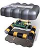
AeroAstro, Inc., has initiated operation its Sensor Enabled Notification System (SENS) service, a highly affordable data monitoring and asset tracking service. Remote data transmitters and service are both immediately available, with a limited-time-only pricing on the transmitters � priced as low as $85/unit. |
|
| The content herein, unless otherwise known to be public domain, are Copyright 1995-2006 - SpaceDaily.AFP and UPI Wire Stories are copyright Agence France-Presse and United Press International. ESA PortalReports are copyright European Space Agency. All NASA sourced material is public domain. Additionalcopyrights may apply in whole or part to other bona fide parties. Advertising does not imply endorsement,agreement or approval of any opinions, statements or information provided by SpaceDaily on any Web page published or hosted by SpaceDaily. Privacy Statement |