| . |  |
. |
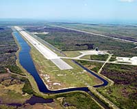
Cape Canaveral FL (SPX) Sep 16, 2004 With the approaching return of the Space Shuttle fleet to flight in 2005, NASA is preparing for their safe arrival home with the recertification of Kennedy Space Center's runway guidance system. Known as the Microwave Scanning Beam Landing System (MSBLS), the system acts like a homing beacon for Space Shuttle orbiters returning to Earth. As an orbiter nears the runway, the system relays information to the pilot such as the vehicle's angle of approach and distance to touchdown, guiding it to a perfect landing. Every two years the MSBLS needs to be certified for accuracy. In the past, NASA has used its own equipment and aircraft for the verification process. However, for the first time NASA will be working with the Federal Aviation Administration to take advantage of its expertise and modern equipment. "The FAA certifies every other navigation aide that there is for commercial aircraft, so we got together," said John Kiriazes, NASA's lead technical engineer for the project. The most obvious sign of the FAA's involvement in the project is the presence of their Bombardier Challenger 601 jet. The Bombardier looks like a typical private jet on the outside, but climb inside and you'll see a bank of computers and equipment taking up half of the passenger cabin. Included in the mass of hardware are receivers for measuring multiples kinds of navigation signals. This jet and its specialized equipment are what NASA's using to test the accuracy of the MSBLS. For this evaluation, the test crew placed a perfectly calibrated GPS navigation unit along the runway to precisely mark a point of reference. This GPS unit broadcasts navigation information from its position to the Bombardier and will be the standard that the MSBLS is compared to. Following placement of the GPS unit, the Bombardier took to the air to make 30 passes over the runway. The aircraft flew passes from different angles to the runway to measure the full spectrum of the MSBLS signal. Throughout the flights, technicians onboard the FAA jet compared the readings from the GPS unit to the MSBLS. If the MSBLS's signal appeared to be off the mark, technicians on the ground were alerted to adjust the system until it matched the GPS's signal. The test showed the MSBLS's signal is very accurate and the system is functioning excellently. In fact, the system is working so well, the MSBLS can place an incoming aircraft within two inches of its actual position in the air. "The aircraft flexes more than that," underscored Kiriazes. Related Links SpaceDaily Search SpaceDaily Subscribe To SpaceDaily Express
 Stennis Space Center MS (SPX) Sep 16, 2004
NASA's Stennis Space Center in Mississippi and the Michoud Assembly Facility in New Orleans are preparing to ride out Hurricane Ivan as it comes ashore on US Gulf Coast. NASA has made preparations to secure important space flight hardware against damage. |
|
| The content herein, unless otherwise known to be public domain, are Copyright 1995-2006 - SpaceDaily.AFP and UPI Wire Stories are copyright Agence France-Presse and United Press International. ESA PortalReports are copyright European Space Agency. All NASA sourced material is public domain. Additionalcopyrights may apply in whole or part to other bona fide parties. Advertising does not imply endorsement,agreement or approval of any opinions, statements or information provided by SpaceDaily on any Web page published or hosted by SpaceDaily. Privacy Statement |